Firebreak esplanades
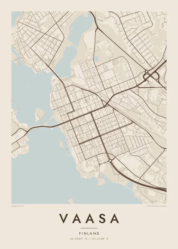
The wide boulevards laid out after the 1852 fire cross the centre in long, open strips, giving the map a strong framework of broad avenues and regular blocks.
Positala ya mapu yosavuta · Finland
63.0960° N / 21.6158° E
Wide esplanades on a planned grid by the Gulf of Bothnia, fraying into the islands of the rising Kvarken archipelago.


Mzinda umodzi, mawonekedwe asanu
Khudzani sitayelo kuti muwone pa khoma. Masitayelo onse amawononga ndalama zofanana — zosindikizidwa, zokutidwa mu chimango kapena ngati mafayilo a HD.
 Ma pixel enieni · fayilo yosindikiza 24 × 36″
Yowala posindikiza
Awa ndi chithunzi 100% chodulidwa cha fayilo yeniyeni yosindikiza. Poster iliyonse — yosindikizidwa, yokutidwa mu chimango kapena yotsitsidwa — imapangidwa pa maseva athu pa 300 DPI, mpaka ma pixel 7,200 × 10,800, choncho ngakhale misewu yaying'ono kwambiri imakhalabe yowoneka bwino pa kope la 24 × 36″.
Pakhoma


Mapu
Vaasa, known in Swedish as Vasa, sits on Finland's west coast facing the Kvarken, the narrow part of the Gulf of Bothnia between Finland and Sweden. After the old town burned in 1852, the city was rebuilt several kilometres closer to the sea on a new plan. Broad tree-lined esplanades were laid out as firebreaks, and on a map they divide the centre into a clean, generous grid.
Around this planned core, the coastline breaks into bays, peninsulas and countless islands. The Kvarken archipelago is a UNESCO World Heritage Site, recognised for its rapid land uplift, as the ground continues to rise after the last Ice Age and new land emerges from the sea. The Replot Bridge, the longest in Finland, links the mainland to the island of Replot.
The city briefly served as the seat of Finland's government during the civil war of 1918, a period still remembered in its history. A Vaasa map poster combines two distinct characters: the precise, orderly grid of a nineteenth-century city and the fragmented, slowly changing shoreline beyond it. The contrast gives the print unusual depth.
The wide boulevards laid out after the 1852 fire cross the centre in long, open strips, giving the map a strong framework of broad avenues and regular blocks.
Hundreds of islands and skerries scatter across the sea to the west, part of a UNESCO site where post-glacial uplift slowly adds new land every year.
Finland's longest bridge carries the road from the mainland out to Replot island, drawing a single straight line across open water in the archipelago.
Ipangeni yanu
Onjezani tsiku, dzina kapena mawu anu, sinthani mawonekedwe, kukula kapena momwe yaimira.
Chitsanzo chaulere ndi chotsika mu resolution ndipo chili ndi chizindikiro chothira madzi. Zosindikizidwa ndi mafayilo a HD zimapangidwa pa 300 DPI, mpaka ma px 7,200 × 10,800, popanda chizindikiro chothira madzi.
Chifukwa chiyani Vaasa
Vaasa draws people through its two language communities, its universities and its energy industry, and many who leave keep a strong attachment to the coast. A map of the city balances street plan and seascape, which makes it a natural fit above a desk or in a hallway.
Set your own title, add a subtitle or a date, and keep or edit the coordinates line. Choose from Classic black & white, Noir, Paper, Blueprint or Sand. The $9 digital download covers six print sizes, and printed posters come on matte paper.
Odara poster ya Vaasa| Kukula kosindikiza | Mphamvu ya chithunzi | Mafayilo |
|---|---|---|
| 30 × 40 cm11.8 × 15.7″ | 3,543 × 4,724 px | PNG · PDF |
| 29.7 × 42 cm (A3)11.7 × 16.5″ | 3,508 × 4,961 px | PNG · PDF |
| 42 × 59.4 cm (A2)16.5 × 23.4″ | 4,961 × 7,016 px | PNG · PDF |
| 45.7 × 61 cm18 × 24″ | 5,400 × 7,200 px | PNG · PDF |
| 50 × 70 cm19.7 × 27.6″ | 5,906 × 8,268 px | PNG · PDF |
| 61 × 91.4 cm24 × 36″ | 7,200 × 10,800 px | PNG · PDF |
Poyerekeza, chithunzi chaulere ndi cha 900 px m'lifupi, chili ndi chizindikiro ndipo ndi cha pa sikirini. Mafayilo a HD ali ndi mphamvu yochulukira mpaka 8× mbali iliyonse ndipo amasindikizika bwino pa kukula konse kwa positala.
Sankhani sitayelo kumtunda kwa tsamba, kenako musankhe Poster Yosindikizidwa — kukula ndi, mukafuna, chimango — kapena Mafayilo a Digital HD. Kulipira kumatenga sitepe imodzi, ndipo tsamba la oda yanu limasinthidwa nthawi yomweyo pambuyo pa kulipira.
Imasindikizidwa pa pepala labwino la matte la 200 gsm mu kukula kumodzi mwa zisanu ndi chimodzi, kuyambira 30 × 40 cm mpaka 24 × 36″. Maposita osindikizidwa amayamba pa $39, kutumiza kuphatikizidwa.
Inde. Sankhani chimango cha mtengo wolimba mu utoto wakuda, woyera, oak wachilengedwe kapena mtengo wakuda. Chimabwera ndi galasi losathyoka ndipo chikonzekera kupachikidwa nthawi yomweyo. Maposita a mu chimango amayamba pa $99, kutumiza kuphatikizidwa.
Kutumiza ndi kwaulere kumayiko oposa 60. Positala iliyonse imasindikizidwa ndi mnzathu wosindikiza wapafupi kwambiri mwa anzathu m'mayiko oposa 30, ndipo nthawi zambiri imafika m'masiku 3–7 antchito. Mukhoza kutsatira momwe oda ilili ndi malo ake pa "Maoda Anga". Mayiko ena amatenga masabata 2–5, ndipo kumene sitinayambe kutumiza, tsambali likuuzani musanalipire.
Titumizireni chithunzi masiku 14 kuchokera pa tsiku la kutumiza ndipo tidzaisindikizanso kwaulere kapena kukubwezerani ndalama zanu.
Inde. Mu chida chokonzera pa tsambali, sinthani mutu, mutu wowonjezera ndi mzere wa ma coordinates kukhala chilichonse chomwe mufuna, ndipo sankhani sitayelo ndi kukula. Maoda osindikizidwa, a mu chimango ndi a digital onse amagwiritsa ntchito kapangidwe kanu enieni.
Pa $9 mumalandira mafayilo a PNG a 300 DPI ndi PDF okonzeka kusindikiza mu kukula konse kwa zisanu ndi chimodzi, popanda chizindikiro chothira madzi, kuti musindikize kulikonse. Simunatsimikize? Tsitsani kaye chitsanzo chaulere chokhala ndi chizindikiro chothira madzi.
Pafupi
