Colonial grid
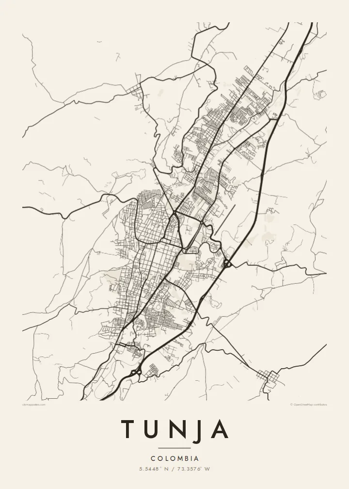
The historic centre keeps its original checkerboard around the Plaza de Bolívar, a square of regular blocks that stands out clearly at the middle of the map.
Ipositeri y'ikarita yoroheje · CO
5.5448° N / 73.3576° W
A high Andean capital laid out in a colonial grid, stretched north to south along a narrow valley between green ridges.




Umujyi umwe, imiterere itanu
Kanda uburyo bumwe kugira ngo ubibone ku rukuta. Buri buryo bufite igiciro kimwe — cyacapwe, gishyizwemo cadre cyangwa mu madosiye HD.
 Pikiseli nyakuri · Dosiye yo gucapa ya 24 × 36″
Bisobanutse neza iyo bicapwe
Iki ni igice cya 100% cy'idosiye nyayo yo gucapa. Buri poster — yacapwe, ishyizwemo cadre cyangwa yakuwe kuri interineti — ikorwa kuri seriveri zacu ku 300 DPI, kugeza kuri pikiseli 7,200 × 10,800, bityo n'imihanda mito cyane igumana ubwiza ku gucapa kwa 24 × 36″.
Ku rukuta


Ikarita
Tunja, the capital of Boyacá, sits at around 2,800 metres, making it one of the highest departmental capitals in Colombia. It lies in a narrow valley running roughly north to south, and the city has grown along that axis rather than outward. On the map the result is an elongated shape, with the colonial centre near the middle and newer districts reaching up the slopes on either side.
Founded by the Spanish in 1539 on the site of a Muisca settlement, Tunja kept its checkerboard plan around the Plaza de Bolívar, one of the largest main squares in the country. Churches and colonial houses line the surrounding blocks. About fifteen kilometres to the south lies the Puente de Boyacá, where the decisive battle for independence was fought in 1819.
A Tunja map poster shows a city defined by both history and terrain. The regular grid of the old centre sits at the heart of the frame, main avenues run along the valley, and the streets bend and thin out where they meet the hills. It is a meaningful map for boyacenses at home or abroad, and for students of the city's universities.
The historic centre keeps its original checkerboard around the Plaza de Bolívar, a square of regular blocks that stands out clearly at the middle of the map.
The city stretches north to south along its valley, with main avenues following the same line and giving the poster a strong vertical composition.
On the edges, newer neighbourhoods climb the slopes, where streets curve with the contours and the tidy grid gives way to a looser, more organic pattern.
Yigire iyawe
Ongeraho itariki, izina cyangwa interuro yawe, uhindure imiterere, ingano cyangwa icyerekezo.
Urugero rw'ubuntu rufite ubwiza buke kandi rufite ikimenyetso cy'amazi. Poster zacapwe n'amadosiye ya HD bikorwa ku 300 DPI, kugeza kuri 7,200 × 10,800 px, nta kimenyetso cy'amazi.
Kuki Tunja
Tunja is a city of students and of families with deep Boyacá roots. A map of its grid and valley is a thoughtful way to remember university years, a hometown or the place near which Colombian independence was won.
The title, subtitle and coordinates line can be personalised with a name, graduation year or date, and five styles are available: Classic black & white, Noir, Paper, Blueprint and Sand. Paper suits the colonial centre especially well.
Tumiza poster ya Tunja| Ingano yo gucapa | Ubwiza bw'ifoto | Amadosiye |
|---|---|---|
| 30 × 40 cm (11.8 × 15.7″) | 3,543 × 4,724 px | PNG · PDF |
| 29.7 × 42 cm (A3, 11.7 × 16.5″) | 3,508 × 4,961 px | PNG · PDF |
| 42 × 59.4 cm (A2, 16.5 × 23.4″) | 4,961 × 7,016 px | PNG · PDF |
| 45.7 × 61 cm (18 × 24″) | 5,400 × 7,200 px | PNG · PDF |
| 50 × 70 cm (19.7 × 27.6″) | 5,906 × 8,268 px | PNG · PDF |
| 61 × 91.4 cm (24 × 36″) | 7,200 × 10,800 px | PNG · PDF |
Ugereranyije, igerageza ry'ubuntu rifite ubugari bwa 900 px, ririho ikirango kandi ryagenewe kurebwa kuri ecran. Amadosiye ya HD afite ubwiza bugera kuri 8× kuri buri ruhande kandi acapwa neza ku ngano yuzuye y'ipositeri.
Hitamo uburyo hejuru y'urupapuro, hanyuma uhitemo Poster Yacapwe — ingano n'niba ubishaka, cadre — cyangwa Amadosiye ya Digital HD. Kwishyura bikorwa mu ntambwe imwe, kandi urupapuro rw'ikurikirana ry'ibyo watumije ruvugururwa vuba nyuma yo kwishyura.
Icapwa ku rupapuro rwa mbere rwa 200 gsm rutagaragaza umucyo, mu ngano imwe muri esheshatu, kuva kuri 30 × 40 cm kugeza kuri 24 × 36″. Poster zacapwe zitangirira kuri $39, harimo no kohereza.
Yego. Hitamo cadre y'igiti gikomeye mu ibara ry'umukara, umweru, oak isanzwe cyangwa igiti cyijimye. Iza n'ikirahure kidacika kandi yiteguye kumanikwa. Poster zifite cadre zitangirira kuri $99, harimo no kohereza.
Kohereza ni ubuntu ku isi hose. Buri paje icapwa n'umwe mu bafatanyabikorwa bacu mu gucapa ukwegereye, mu bihugu birenga 30, kandi akenshi igera ku muguzi mu minsi 3–7 y'akazi. Ushobora gukurikirana uko iteye n'aho igeze muri "Ibyo naguze". Ibihugu bimwe bifata ibyumweru 2–5, naho aho tutarohereza, urubuga ruzakubwira mbere y'uko wishyura.
Twoherereze ifoto mu minsi 14 ikurikira igihe cyo kuyakira, kandi tuzayicapa bundi bushya ku buntu cyangwa tukagusubiza amafaranga.
Yego. Muri editor iri kuri uru rupapuro, hindura umutwe, ikirongo cy'inyongera n'umurongo w'ibipimo ukagira icyo ushaka, hanyuma ugahitamo uburyo n'ingano. Amatumizo yacapwe, afite cadre n'aya digital yose akoresha ishushanyo ryawe nk'uko ryifashe.
Ku $9 ubona amadosiye ya PNG ya 300 DPI n'aya PDF yiteguye gucapwa mu ngano zose esheshatu, nta kimenyetso cy'amazi, ushobora gucapa aho ariho hose. Ntucyemeje? Banza umanure urugero rw'ubuntu rufite ikimenyetso cy'amazi.
Hafi aho
