Lake Basotu
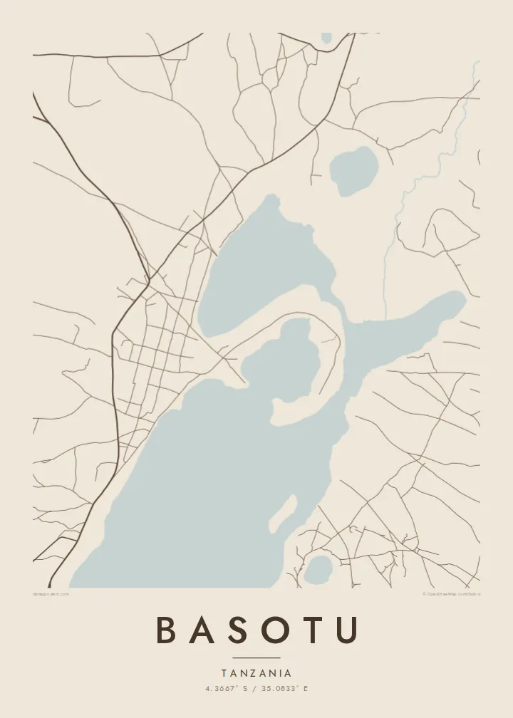
The lake beside the town is the dominant form on the map. Its solid shape anchors the composition and gives the settlement its outline along the shore.
Posta faʻafanua faigofie · Tanzania
4.3667° S / 35.0833° E
A small Hanang town beside the waters of Lake Basotu, with open farmland and scattered tracks spreading in every direction.


Tasi le aai, lagona e lima
Tapi se sitaili e vaai ai i luga o le puipui. E tutusa uma le tau o sitaili — pe lolomiina, faapipiiina, pe avea ma faila HD.
 Pika Moni · Faila Lolomi 24 × 36″
Manino mo le lolomi
O se vaega atoa (100%) lenei mai le faila lolomi moni. O posita uma — pe lolomiina, faapipiiina pe download mai — e faia i luga o a matou server i le 300 DPI, e oo atu i le 7,200 × 10,800 pika, ina ia manino pea auala laiti i luga o se lolomiga 24 × 36″.
I luga o le puipui


Le faʻafanua
Basotu lies in Hanang District of Manyara Region, in the highlands of northern Tanzania. From above, the most striking feature is water. Lake Basotu sits right beside the town, a compact body of water that gives the map a clear focal point in otherwise open country. Houses and compounds cluster near its shore, and unpaved roads fan out toward villages and fields.
The wider district is dominated by Mount Hanang, one of the highest peaks in Tanzania, which rises to the east. The plains around Basotu are farming and grazing land, home to Barabaig and Iraqw communities among others, and large wheat farms have been part of the area's story. On the map this appears as broad, lightly marked terrain rather than dense streets.
Because the settlement is small, a Basotu map poster works best as a portrait of the place and its setting together: the shape of the lake, the loose ring of buildings and the few tracks heading out across the land. It is a sparse, calm composition, and that restraint is exactly what makes it read well in black and white.
The lake beside the town is the dominant form on the map. Its solid shape anchors the composition and gives the settlement its outline along the shore.
Unpaved roads leave the town in several directions toward farms and neighbouring villages. They draw thin lines across open ground and show how much space surrounds Basotu.
The town belongs to the district named after Mount Hanang, a free-standing volcanic mountain to the east that defines the wider landscape of this part of Manyara.
Fai mo oe
Faʻaopoopo se aso, se igoa po o sau lava upu, sui le sitaili, lapoʻa po o le itu.
O le preview e leai se totogi e maualalo le resolution ma iai se watermark. O lolomi ma faila HD e faia i le 300 DPI, e oo atu i le 7,200 × 10,800 px, e aunoa ma se watermark.
Aisea Basotu
A map of Basotu usually belongs to someone with a direct connection: people who were born here, taught or worked in the district, or spent time on a project near the lake. It records a quiet place that rarely appears on any printed map.
You can personalise the title, subtitle and coordinates line, perhaps with the years you lived there. The design comes in five styles (Classic black & white, Noir, Paper, Blueprint and Sand) and can be downloaded as 300 DPI files or ordered as a printed poster.
Faatau le posita Basotu| Lapoʻa lolomi | Manino | Faila |
|---|---|---|
| 30 × 40 cm (11.8 × 15.7″) | 3,543 × 4,724 px | PNG · PDF |
| 29.7 × 42 cm (A3, 11.7 × 16.5″) | 3,508 × 4,961 px | PNG · PDF |
| 42 × 59.4 cm (A2, 16.5 × 23.4″) | 4,961 × 7,016 px | PNG · PDF |
| 45.7 × 61 cm (18 × 24″) | 5,400 × 7,200 px | PNG · PDF |
| 50 × 70 cm (19.7 × 27.6″) | 5,906 × 8,268 px | PNG · PDF |
| 61 × 91.4 cm (24 × 36″) | 7,200 × 10,800 px | PNG · PDF |
Ae faʻatusatusa, o le faʻataʻitaʻiga e leai se totogi e 900 px le lautele, e iai le faʻailoga vai ma e mo mata. O faila HD e oʻo atu i le 8× le manino i itu taʻitasi ma e lolomi manino i le lapoʻa atoa o le posta.
Filifili se sitaili i le pito i luga o le itulau, ona filifili lea o le Posita Lolomi — se lapopoa ma, afai e te fiafia, se faavaa — po o Faila HD Numera. E na o le tasi laasaga o le Checkout, ma o le a fesuia'i lou itulau o oka i le taimi lava e mae'a ai le totogi.
E lolomiina i luga o pepa matte maualuga le tulaga e 200 gsm, i se tasi o lapopoa e ono, mai le 30 × 40 cm i le 24 × 36″. E amata le tau o posita lolomi mai le $39, aofia ai le auina atu.
Ioe. Filifili se faavaa laau malosi i le lanu uliuli, sina, oak masani, po o le laau pogisa. E aofia ai se tioata e le gau ma ua saunia e tautau i luga. E amata le tau o posita faavaa mai le $99, aofia ai le auina atu.
E leai se totogi mo le uta i le lalolagi atoa. O poster ta'itasi e lolomi e le paaga lolomi e latalata mai i matou i atunuu e 30+, ma e masani ona taunuu i aso faigaluega e 3–7. E mafai ona e mulimuli i le tulaga ma le tracking i le "Aʻu Oka". O nisi atunuu e 2–5 vaiaso, ma i atunuu matou te lei tuuina atu ai, e taʻu atu e le saite iā te oe ae e te leʻi totogiina.
Auina mai se ata i totonu o le 14 aso talu ona taunuu, ma o le a matou toe lolomiina e leai se totogi po o le toe faafoi atu lau tupe.
Ioe. I totonu o le editor i lenei itulau, suia le ulutala, le ulutala laititi ma le laina o coordinates i soo se mea e te fiafia i ai, ma filifili se sitaili ma le lapopoa. O oka lolomi, faavaa ma numera e faaaoga uma lava lau mamanu.
Mo le $9 e te maua ai faila PNG 300 DPI ma PDF ua saunia mo le lolomi i lapopoa uma e ono, e aunoa ma se watermark, e mafai ona lolomi i soo se mea. Le mautinoa lava? Download muamua se preview e leai se totogi ma le watermark.
Latalata ane
