The Gond ramparts
The historic wall and its gates still shape the street pattern, leaving a clear ring of older, tighter lanes at the centre of the modern city.
Posta faʻafanua faigofie · India
19.9508° N / 79.2952° E
An old walled town between two small rivers, its stone circuit still traced by roads that loop the historic core.


Tasi le aai, lagona e lima
Tapi se sitaili e vaai ai i luga o le puipui. E tutusa uma le tau o sitaili — pe lolomiina, faapipiiina, pe avea ma faila HD.
 Pika Moni · Faila Lolomi 24 × 36″
Manino mo le lolomi
O se vaega atoa (100%) lenei mai le faila lolomi moni. O posita uma — pe lolomiina, faapipiiina pe download mai — e faia i luga o a matou server i le 300 DPI, e oo atu i le 7,200 × 10,800 pika, ina ia manino pea auala laiti i luga o se lolomiga 24 × 36″.
I luga o le puipui


Le faʻafanua
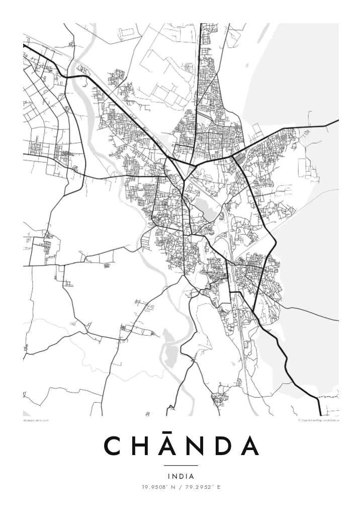
Chānda, officially Chandrapur, grew up inside a long stone wall built under the Gond kings who ruled this part of eastern Maharashtra. On a map the old town still shows that outline: a rough loop of roads following the line of the ramparts, with gateways where traffic squeezes through and denser lanes packed inside. Newer districts spread outward in looser blocks on every side.
Water frames the town to the west and east. The Erai River runs down its western edge and the smaller Zarpat stream passes the eastern side, so the built-up area sits on the higher ground between two thin blue lines. Rail tracks and highways cut across the plain, and broad industrial sites mark the power station and coal workings that made the district's name.
A Chānda map poster reduces all of this to line and space: the curve of the old wall, the river channels, the rail spur and the grid of the newer colonies. Beyond the frame lies the teak forest of Tadoba-Andhari Tiger Reserve, one of Maharashtra's best-known wildlife areas, which gives the town a reputation that reaches well past its coal and cement.
The historic wall and its gates still shape the street pattern, leaving a clear ring of older, tighter lanes at the centre of the modern city.
The Erai runs along the western side of town, a narrow river line that gives the map a firm boundary and a sense of direction.
Large rectangular footprints of the thermal power station and mining areas sit on the fringes, contrasting sharply with the fine grain of the old town.
Fai mo oe
Faʻaopoopo se aso, se igoa po o sau lava upu, sui le sitaili, lapoʻa po o le itu.
O le preview e leai se totogi e maualalo le resolution ma iai se watermark. O lolomi ma faila HD e faia i le 300 DPI, e oo atu i le 7,200 × 10,800 px, e aunoa ma se watermark.
Aisea Chānda
People from Chandrapur often carry the old town in their heads as a set of gates and turns. A framed map puts that memory on the wall, whether it marks a family home, a first posting, or a stop on the way to the tiger reserve.
The title, subtitle and coordinates line can be changed to a name, a date or a phrase. Choose Classic black & white, Noir, Paper, Blueprint or Sand, download the HD files for $9, or order a matte print with an optional wooden frame.
Faatau le posita Chānda| Lapoʻa lolomi | Manino | Faila |
|---|---|---|
| 30 × 40 cm (11.8 × 15.7″) | 3,543 × 4,724 px | PNG · PDF |
| 29.7 × 42 cm (A3, 11.7 × 16.5″) | 3,508 × 4,961 px | PNG · PDF |
| 42 × 59.4 cm (A2, 16.5 × 23.4″) | 4,961 × 7,016 px | PNG · PDF |
| 45.7 × 61 cm (18 × 24″) | 5,400 × 7,200 px | PNG · PDF |
| 50 × 70 cm (19.7 × 27.6″) | 5,906 × 8,268 px | PNG · PDF |
| 61 × 91.4 cm (24 × 36″) | 7,200 × 10,800 px | PNG · PDF |
Ae faʻatusatusa, o le faʻataʻitaʻiga e leai se totogi e 900 px le lautele, e iai le faʻailoga vai ma e mo mata. O faila HD e oʻo atu i le 8× le manino i itu taʻitasi ma e lolomi manino i le lapoʻa atoa o le posta.
Filifili se sitaili i le pito i luga o le itulau, ona filifili lea o le Posita Lolomi — se lapopoa ma, afai e te fiafia, se faavaa — po o Faila HD Numera. E na o le tasi laasaga o le Checkout, ma o le a fesuia'i lou itulau o oka i le taimi lava e mae'a ai le totogi.
E lolomiina i luga o pepa matte maualuga le tulaga e 200 gsm, i se tasi o lapopoa e ono, mai le 30 × 40 cm i le 24 × 36″. E amata le tau o posita lolomi mai le {printFrom}, aofia ai le auina atu.
Ioe. Filifili se faavaa laau malosi i le lanu uliuli, sina, oak masani, po o le laau pogisa. E aofia ai se tioata e le gau ma ua saunia e tautau i luga. E amata le tau o posita faavaa mai le {framedFrom}, aofia ai le auina atu.
E leai se totogi mo le uta i le lalolagi atoa. O poster ta'itasi e lolomi e le paaga lolomi e latalata mai i matou i atunuu e 30+, ma e masani ona taunuu i aso faigaluega e 3–7. E mafai ona e mulimuli i le tulaga ma le tracking i le "Aʻu Oka". O nisi atunuu e 2–5 vaiaso, ma i atunuu matou te lei tuuina atu ai, e taʻu atu e le saite iā te oe ae e te leʻi totogiina.
Auina mai se ata i totonu o le 14 aso talu ona taunuu, ma o le a matou toe lolomiina e leai se totogi po o le toe faafoi atu lau tupe.
Ioe. I totonu o le editor i lenei itulau, suia le ulutala, le ulutala laititi ma le laina o coordinates i soo se mea e te fiafia i ai, ma filifili se sitaili ma le lapopoa. O oka lolomi, faavaa ma numera e faaaoga uma lava lau mamanu.
Mo le $9 e te maua ai faila PNG 300 DPI ma PDF ua saunia mo le lolomi i lapopoa uma e ono, e aunoa ma se watermark, e mafai ona lolomi i soo se mea. Le mautinoa lava? Download muamua se preview e leai se totogi ma le watermark.
