Leidse Rijn
The old waterway runs through the village, and the historic streets follow it. On the print it appears as a thin, steady line with buildings along both sides.
Posta faʻafanua faigofie · Netherlands
52.0817° N / 5.0361° E
A former village on the old Rhine course west of Utrecht, now framed by motorways, canals and the new Leidsche Rijn district



Tasi le aai, lagona e lima
Tapi se sitaili e vaai ai i luga o le puipui. E tutusa uma le tau o sitaili — pe lolomiina, faapipiiina, pe avea ma faila HD.
 Pika Moni · Faila Lolomi 24 × 36″
Manino mo le lolomi
O se vaega atoa (100%) lenei mai le faila lolomi moni. O posita uma — pe lolomiina, faapipiiina pe download mai — e faia i luga o a matou server i le 300 DPI, e oo atu i le 7,200 × 10,800 pika, ina ia manino pea auala laiti i luga o se lolomiga 24 × 36″.
I luga o le puipui


Le faʻafanua
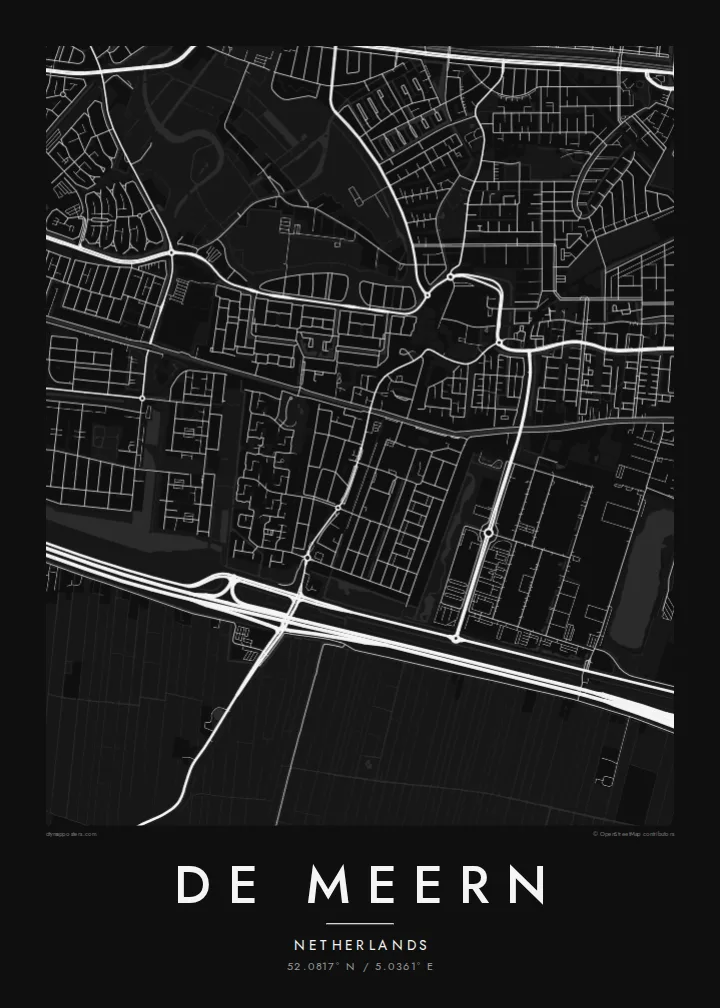
De Meern lies just west of Utrecht, part of the combined district of Vleuten-De Meern. From above, the older village follows the line of the Leidse Rijn, a waterway along an old course of the Rhine. Long, narrow streets run parallel to the water, and a straight, flat pattern of Dutch polder fields surrounds it.
That old river route was once the northern frontier of the Roman Empire. In 2003, archaeologists found a well-preserved Roman river barge here, known as De Meern 1. The nearby Roman fort site at Hoge Woerd is now marked by a reconstructed castellum. Around the village, the new Leidsche Rijn development has added large planned neighbourhoods, parks and water features.
A De Meern map poster combines different eras: a linear village along the water, modern curving neighbourhoods, straight drainage ditches and the motorways that pass nearby. It suits people who moved into the new district, those who grew up in the old village and anyone with an interest in the Roman frontier.
The old waterway runs through the village, and the historic streets follow it. On the print it appears as a thin, steady line with buildings along both sides.
The Limes once ran along this river course. The site at Hoge Woerd, where a Roman fort stood, is part of the area shown on the map.
The planned neighbourhoods of Leidsche Rijn surround the older village with parks, canals and curving streets. Together they make a sharp contrast with the linear core.
Fai mo oe
Faʻaopoopo se aso, se igoa po o sau lava upu, sui le sitaili, lapoʻa po o le itu.
O le preview e leai se totogi e maualalo le resolution ma iai se watermark. O lolomi ma faila HD e faia i le 300 DPI, e oo atu i le 7,200 × 10,800 px, e aunoa ma se watermark.
Aisea De Meern
Many families moved to De Meern as the new district grew, and a map marks that first home well. Longtime residents often choose it to show how the old village sits within the new city.
Put your street, family name or moving-in date in the title and subtitle, and keep the coordinates. Choose Classic black & white, Noir, Paper, Blueprint or Sand. Blueprint shows the waterways clearly.
Faatau le posita De Meern| Lapoʻa lolomi | Manino | Faila |
|---|---|---|
| 30 × 40 cm11.8 × 15.7″ | 3,543 × 4,724 px | PNG · PDF |
| 29.7 × 42 cm (A3)11.7 × 16.5″ | 3,508 × 4,961 px | PNG · PDF |
| 42 × 59.4 cm (A2)16.5 × 23.4″ | 4,961 × 7,016 px | PNG · PDF |
| 45.7 × 61 cm18 × 24″ | 5,400 × 7,200 px | PNG · PDF |
| 50 × 70 cm19.7 × 27.6″ | 5,906 × 8,268 px | PNG · PDF |
| 61 × 91.4 cm24 × 36″ | 7,200 × 10,800 px | PNG · PDF |
Ae faʻatusatusa, o le faʻataʻitaʻiga e leai se totogi e 900 px le lautele, e iai le faʻailoga vai ma e mo mata. O faila HD e oʻo atu i le 8× le manino i itu taʻitasi ma e lolomi manino i le lapoʻa atoa o le posta.
Filifili se sitaili i le pito i luga o le itulau, ona filifili lea o le Posita Lolomi — se lapopoa ma, afai e te fiafia, se faavaa — po o Faila HD Numera. E na o le tasi laasaga o le Checkout, ma o le a fesuia'i lou itulau o oka i le taimi lava e mae'a ai le totogi.
E lolomiina i luga o pepa matte maualuga le tulaga e 200 gsm, i se tasi o lapopoa e ono, mai le 30 × 40 cm i le 24 × 36″. E amata le tau o posita lolomi mai le $39, aofia ai le auina atu.
Ioe. Filifili se faavaa laau malosi i le lanu uliuli, sina, oak masani, po o le laau pogisa. E aofia ai se tioata e le gau ma ua saunia e tautau i luga. E amata le tau o posita faavaa mai le $99, aofia ai le auina atu.
E leai se totogi o le auina atu i atunuu e 60+. O pepa ata taʻitasi e lolomiina e le tasi o matou paaga lolomi e latalata mai i atunuu e 30+, ma e masani ona taunuu i le 3–7 aso faigaluega. E mafai ona e mulimulitaia le tulaga ma le sailiga i lalo o My Orders. O nisi atunuu e 2–5 vaiaso, ma i nofoaga e lei matou auina atu iai, e taʻu atu e le saite ia te oe a o lei totogi.
Auina mai se ata i totonu o le 14 aso talu ona taunuu, ma o le a matou toe lolomiina e leai se totogi po o le toe faafoi atu lau tupe.
Ioe. I totonu o le editor i lenei itulau, suia le ulutala, le ulutala laititi ma le laina o coordinates i soo se mea e te fiafia i ai, ma filifili se sitaili ma le lapopoa. O oka lolomi, faavaa ma numera e faaaoga uma lava lau mamanu.
Mo le $9 e te maua ai faila PNG 300 DPI ma PDF ua saunia mo le lolomi i lapopoa uma e ono, e aunoa ma se watermark, e mafai ona lolomi i soo se mea. Le mautinoa lava? Download muamua se preview e leai se totogi ma le watermark.
Latalata ane
