Hill-shaped streets
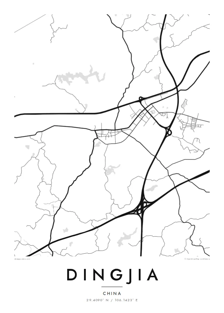
Rather than forming a regular grid, the town's streets bend and branch to follow the contours of the hills. The result is a loose, organic pattern at the centre of the map.
Posta faʻafanua faigofie · China
29.4090° N / 106.1423° E
A town in the hills of western Chongqing, where streets bend to fit the slopes and farmland fills the valleys.


Tasi le aai, lagona e lima
Tapi se sitaili e vaai ai i luga o le puipui. E tutusa uma le tau o sitaili — pe lolomiina, faapipiiina, pe avea ma faila HD.
 Pika Moni · Faila Lolomi 24 × 36″
Manino mo le lolomi
O se vaega atoa (100%) lenei mai le faila lolomi moni. O posita uma — pe lolomiina, faapipiiina pe download mai — e faia i luga o a matou server i le 300 DPI, e oo atu i le 7,200 × 10,800 pika, ina ia manino pea auala laiti i luga o se lolomiga 24 × 36″.
I luga o le puipui


Le faʻafanua
Dingjia lies in the western part of Chongqing Municipality, in the hilly country that covers much of the Sichuan Basin. On a map the town forms a compact settlement shaped by the terrain. Streets follow the lower ground and curve around rises, while the surrounding land is broken into small fields, terraces, ponds and patches of woodland. Main roads link it with neighbouring towns across the rolling countryside.
The land around Dingjia is farmed and densely settled, with small villages scattered between the hills and field patterns refined over generations. In recent decades, better roads and expressways have drawn towns like this one closer to the growing urban districts of Chongqing, while the countryside around them keeps much of its rural character.
A Dingjia map poster captures a landscape where every road responds to the land. The town centre appears as a dense cluster of lines, the rural roads wind outward in irregular curves, and small ponds and reservoirs dot the composition. It is a thoughtful keepsake for people who grew up here and now live in the city or further away.
Rather than forming a regular grid, the town's streets bend and branch to follow the contours of the hills. The result is a loose, organic pattern at the centre of the map.
Small bodies of water are scattered across the countryside, as in many farming areas of the Sichuan Basin. On the poster they appear as quiet pale shapes.
Narrow roads wind between fields and villages in every direction. They fill the outer part of the map with fine, irregular lines that contrast with the denser core.
Fai mo oe
Faʻaopoopo se aso, se igoa po o sau lava upu, sui le sitaili, lapoʻa po o le itu.
O le preview e leai se totogi e maualalo le resolution ma iai se watermark. O lolomi ma faila HD e faia i le 300 DPI, e oo atu i le 7,200 × 10,800 px, e aunoa ma se watermark.
Aisea Dingjia
Many people from towns like Dingjia have moved to larger cities, and a map is a simple way to keep a sense of home. It shows the streets and surrounding hills clearly, without decoration, in a form that suits a modern interior.
Choose Classic black & white, Noir, Paper, Blueprint or Sand, and personalise the title, subtitle and coordinates line with a family name or a date. The $9 download includes six print sizes, and printed posters are available with an optional wooden frame.
Faatau le posita Dingjia| Lapoʻa lolomi | Manino | Faila |
|---|---|---|
| 30 × 40 cm (11.8 × 15.7″) | 3,543 × 4,724 px | PNG · PDF |
| 29.7 × 42 cm (A3, 11.7 × 16.5″) | 3,508 × 4,961 px | PNG · PDF |
| 42 × 59.4 cm (A2, 16.5 × 23.4″) | 4,961 × 7,016 px | PNG · PDF |
| 45.7 × 61 cm (18 × 24″) | 5,400 × 7,200 px | PNG · PDF |
| 50 × 70 cm (19.7 × 27.6″) | 5,906 × 8,268 px | PNG · PDF |
| 61 × 91.4 cm (24 × 36″) | 7,200 × 10,800 px | PNG · PDF |
Ae faʻatusatusa, o le faʻataʻitaʻiga e leai se totogi e 900 px le lautele, e iai le faʻailoga vai ma e mo mata. O faila HD e oʻo atu i le 8× le manino i itu taʻitasi ma e lolomi manino i le lapoʻa atoa o le posta.
Filifili se sitaili i le pito i luga o le itulau, ona filifili lea o le Posita Lolomi — se lapopoa ma, afai e te fiafia, se faavaa — po o Faila HD Numera. E na o le tasi laasaga o le Checkout, ma o le a fesuia'i lou itulau o oka i le taimi lava e mae'a ai le totogi.
E lolomiina i luga o pepa matte maualuga le tulaga e 200 gsm, i se tasi o lapopoa e ono, mai le 30 × 40 cm i le 24 × 36″. E amata le tau o posita lolomi mai le {printFrom}, aofia ai le auina atu.
Ioe. Filifili se faavaa laau malosi i le lanu uliuli, sina, oak masani, po o le laau pogisa. E aofia ai se tioata e le gau ma ua saunia e tautau i luga. E amata le tau o posita faavaa mai le {framedFrom}, aofia ai le auina atu.
E leai se totogi mo le uta i le lalolagi atoa. O poster ta'itasi e lolomi e le paaga lolomi e latalata mai i matou i atunuu e 30+, ma e masani ona taunuu i aso faigaluega e 3–7. E mafai ona e mulimuli i le tulaga ma le tracking i le "Aʻu Oka". O nisi atunuu e 2–5 vaiaso, ma i atunuu matou te lei tuuina atu ai, e taʻu atu e le saite iā te oe ae e te leʻi totogiina.
Auina mai se ata i totonu o le 14 aso talu ona taunuu, ma o le a matou toe lolomiina e leai se totogi po o le toe faafoi atu lau tupe.
Ioe. I totonu o le editor i lenei itulau, suia le ulutala, le ulutala laititi ma le laina o coordinates i soo se mea e te fiafia i ai, ma filifili se sitaili ma le lapopoa. O oka lolomi, faavaa ma numera e faaaoga uma lava lau mamanu.
Mo le $9 e te maua ai faila PNG 300 DPI ma PDF ua saunia mo le lolomi i lapopoa uma e ono, e aunoa ma se watermark, e mafai ona lolomi i soo se mea. Le mautinoa lava? Download muamua se preview e leai se totogi ma le watermark.
Latalata ane
