Nandu River delta
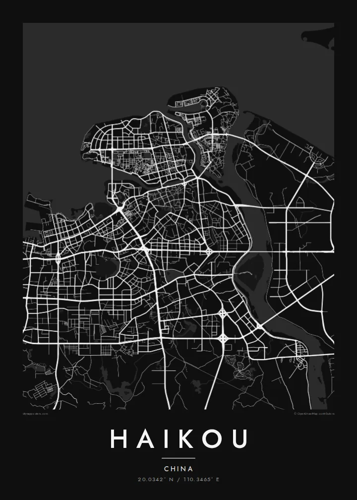
Hainan's longest river ends at Haikou and splits into several channels before reaching the sea. These branches and the islands between them define the eastern half of the city map.
Posta faʻafanua faigofie · China
20.0342° N / 110.3465° E
Hainan's capital on the Qiongzhou Strait, where a river delta, low islands and a curved coastline meet a growing grid



Tasi le aai, lagona e lima
Tapi se sitaili e vaai ai i luga o le puipui. E tutusa uma le tau o sitaili — pe lolomiina, faapipiiina, pe avea ma faila HD.
 Pika Moni · Faila Lolomi 24 × 36″
Manino mo le lolomi
O se vaega atoa (100%) lenei mai le faila lolomi moni. O posita uma — pe lolomiina, faapipiiina pe download mai — e faia i luga o a matou server i le 300 DPI, e oo atu i le 7,200 × 10,800 pika, ina ia manino pea auala laiti i luga o se lolomiga 24 × 36″.
I luga o le puipui


Le faʻafanua
Haikou is the capital of Hainan and sits on the island's northern coast, facing mainland China across the Qiongzhou Strait. From above, the city spreads along a long, gently curved shoreline. The Nandu River, Hainan's largest river, reaches the sea here and breaks into channels and low islands, so the eastern side of the map is cut by water.
Haidian Island lies just off the old centre, separated by a narrow river channel and linked by several bridges. The older town near the waterfront keeps its denser, smaller streets, including the arcaded qilou buildings of the historic quarter. Further west and south, newer districts run on a wider, more regular grid of avenues, with parks and residential blocks in between.
The coast west of the centre is marked by beaches, a ferry port and long seafront roads. Inland to the southwest, the land rises slightly toward an old volcanic area. A Haikou map poster shows how the city is shaped by the strait on one side and the delta on the other, with the old port in the middle.
Hainan's longest river ends at Haikou and splits into several channels before reaching the sea. These branches and the islands between them define the eastern half of the city map.
A low island separated from the old centre by a narrow channel. Bridges cross to it at several points, and its northern edge follows the open coastline.
The historic centre near the river mouth has narrow streets lined with arcaded qilou buildings. On the map it appears as a compact, dense block of small streets next to the water.
Fai mo oe
Faʻaopoopo se aso, se igoa po o sau lava upu, sui le sitaili, lapoʻa po o le itu.
O le preview e leai se totogi e maualalo le resolution ma iai se watermark. O lolomi ma faila HD e faia i le 300 DPI, e oo atu i le 7,200 × 10,800 px, e aunoa ma se watermark.
Aisea Haikou
Haikou is where many journeys to Hainan begin, by ferry or plane, and it is home to people who know its seafront and river neighbourhoods well. Its outline of coast, delta and islands works well as a simple, clean wall piece.
You can personalise the title, subtitle and coordinates, for instance with a move date or a family name, and pick Classic black & white, Noir, Paper, Blueprint or Sand. Buy it as a digital file or have it printed and shipped.
Faatau le posita Haikou| Lapoʻa lolomi | Manino | Faila |
|---|---|---|
| 30 × 40 cm11.8 × 15.7″ | 3,543 × 4,724 px | PNG · PDF |
| 29.7 × 42 cm (A3)11.7 × 16.5″ | 3,508 × 4,961 px | PNG · PDF |
| 42 × 59.4 cm (A2)16.5 × 23.4″ | 4,961 × 7,016 px | PNG · PDF |
| 45.7 × 61 cm18 × 24″ | 5,400 × 7,200 px | PNG · PDF |
| 50 × 70 cm19.7 × 27.6″ | 5,906 × 8,268 px | PNG · PDF |
| 61 × 91.4 cm24 × 36″ | 7,200 × 10,800 px | PNG · PDF |
Ae faʻatusatusa, o le faʻataʻitaʻiga e leai se totogi e 900 px le lautele, e iai le faʻailoga vai ma e mo mata. O faila HD e oʻo atu i le 8× le manino i itu taʻitasi ma e lolomi manino i le lapoʻa atoa o le posta.
Filifili se sitaili i le pito i luga o le itulau, ona filifili lea o le Posita Lolomi — se lapopoa ma, afai e te fiafia, se faavaa — po o Faila HD Numera. E na o le tasi laasaga o le Checkout, ma o le a fesuia'i lou itulau o oka i le taimi lava e mae'a ai le totogi.
E lolomiina i luga o pepa matte maualuga le tulaga e 200 gsm, i se tasi o lapopoa e ono, mai le 30 × 40 cm i le 24 × 36″. E amata le tau o posita lolomi mai le $39, aofia ai le auina atu.
Ioe. Filifili se faavaa laau malosi i le lanu uliuli, sina, oak masani, po o le laau pogisa. E aofia ai se tioata e le gau ma ua saunia e tautau i luga. E amata le tau o posita faavaa mai le $99, aofia ai le auina atu.
E leai se totogi o le auina atu i atunuu e 60+. O pepa ata taʻitasi e lolomiina e le tasi o matou paaga lolomi e latalata mai i atunuu e 30+, ma e masani ona taunuu i le 3–7 aso faigaluega. E mafai ona e mulimulitaia le tulaga ma le sailiga i lalo o My Orders. O nisi atunuu e 2–5 vaiaso, ma i nofoaga e lei matou auina atu iai, e taʻu atu e le saite ia te oe a o lei totogi.
Auina mai se ata i totonu o le 14 aso talu ona taunuu, ma o le a matou toe lolomiina e leai se totogi po o le toe faafoi atu lau tupe.
Ioe. I totonu o le editor i lenei itulau, suia le ulutala, le ulutala laititi ma le laina o coordinates i soo se mea e te fiafia i ai, ma filifili se sitaili ma le lapopoa. O oka lolomi, faavaa ma numera e faaaoga uma lava lau mamanu.
Mo le $9 e te maua ai faila PNG 300 DPI ma PDF ua saunia mo le lolomi i lapopoa uma e ono, e aunoa ma se watermark, e mafai ona lolomi i soo se mea. Le mautinoa lava? Download muamua se preview e leai se totogi ma le watermark.
Latalata ane
