Indented coastline
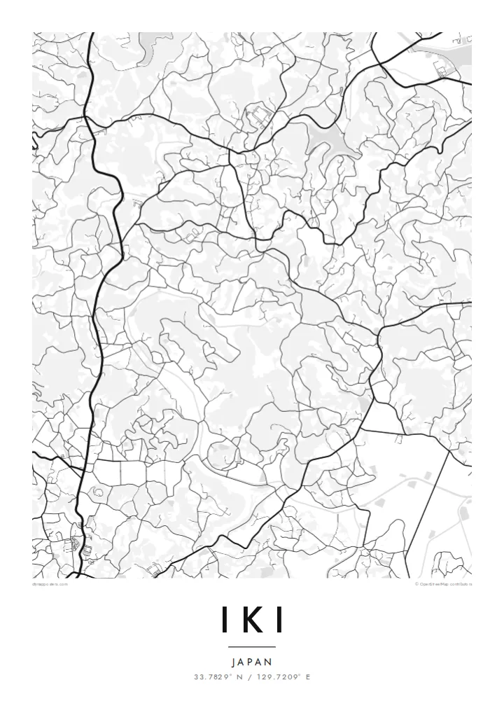
Countless small bays, headlands and islets surround the island, producing an intricate edge that looks especially striking against open water on the map.
Posta faʻafanua faigofie · Japan
33.7829° N / 129.7209° E
An island city in the strait between Kyushu and Tsushima, low hills and small harbours tucked into a ragged coastline.


Tasi le aai, lagona e lima
Tapi se sitaili e vaai ai i luga o le puipui. E tutusa uma le tau o sitaili — pe lolomiina, faapipiiina, pe avea ma faila HD.
 Pika Moni · Faila Lolomi 24 × 36″
Manino mo le lolomi
O se vaega atoa (100%) lenei mai le faila lolomi moni. O posita uma — pe lolomiina, faapipiiina pe download mai — e faia i luga o a matou server i le 300 DPI, e oo atu i le 7,200 × 10,800 pika, ina ia manino pea auala laiti i luga o se lolomiga 24 × 36″.
I luga o le puipui


Le faʻafanua
Iki is an island city in Nagasaki Prefecture, set in the strait between northern Kyushu and Tsushima. The whole island fits on a single map: a compact, roughly rounded landmass with a heavily indented coastline, small bays and offshore islets. Inland, low hills and a surprisingly broad central plain are covered in fields and scattered villages rather than steep mountains.
Towns cluster around the harbours. Gōnoura in the southwest is the main ferry port, while Ashibe and others sit on sheltered inlets elsewhere on the coast. Roads loop between them across the island, and the network of rural lanes connecting farms gives the interior a fine, branching texture.
Iki has a long history as a stepping stone between Japan and the Asian mainland. The Harunotsuji site on the island is thought to be the centre of Ikikoku, one of the states mentioned in ancient Chinese records. The island is also known for barley shochu. An Iki map poster frames an entire island in one clear, legible shape.
Countless small bays, headlands and islets surround the island, producing an intricate edge that looks especially striking against open water on the map.
The main port sits in a sheltered bay on the southwest coast, where the densest streets meet ferry terminals and fishing piers.
The interior is unusually flat for an island in the region, with fields, farm roads and small settlements spread evenly across it.
Fai mo oe
Faʻaopoopo se aso, se igoa po o sau lava upu, sui le sitaili, lapoʻa po o le itu.
O le preview e leai se totogi e maualalo le resolution ma iai se watermark. O lolomi ma faila HD e faia i le 300 DPI, e oo atu i le 7,200 × 10,800 px, e aunoa ma se watermark.
Aisea Iki
Island maps have a completeness that city maps rarely do, and Iki is a fine example. It suits islanders who moved to the mainland, frequent visitors, and anyone drawn to Japan's quieter coastal places.
Add a name, a date or a line in Japanese to the title, subtitle and coordinates line. Choose among five styles, with Blueprint and Noir working especially well for coastlines, and download HD files for $9 or order a printed poster.
Faatau le posita Iki| Lapoʻa lolomi | Manino | Faila |
|---|---|---|
| 30 × 40 cm (11.8 × 15.7″) | 3,543 × 4,724 px | PNG · PDF |
| 29.7 × 42 cm (A3, 11.7 × 16.5″) | 3,508 × 4,961 px | PNG · PDF |
| 42 × 59.4 cm (A2, 16.5 × 23.4″) | 4,961 × 7,016 px | PNG · PDF |
| 45.7 × 61 cm (18 × 24″) | 5,400 × 7,200 px | PNG · PDF |
| 50 × 70 cm (19.7 × 27.6″) | 5,906 × 8,268 px | PNG · PDF |
| 61 × 91.4 cm (24 × 36″) | 7,200 × 10,800 px | PNG · PDF |
Ae faʻatusatusa, o le faʻataʻitaʻiga e leai se totogi e 900 px le lautele, e iai le faʻailoga vai ma e mo mata. O faila HD e oʻo atu i le 8× le manino i itu taʻitasi ma e lolomi manino i le lapoʻa atoa o le posta.
Filifili se sitaili i le pito i luga o le itulau, ona filifili lea o le Posita Lolomi — se lapopoa ma, afai e te fiafia, se faavaa — po o Faila HD Numera. E na o le tasi laasaga o le Checkout, ma o le a fesuia'i lou itulau o oka i le taimi lava e mae'a ai le totogi.
E lolomiina i luga o pepa matte maualuga le tulaga e 200 gsm, i se tasi o lapopoa e ono, mai le 30 × 40 cm i le 24 × 36″. E amata le tau o posita lolomi mai le $39, aofia ai le auina atu.
Ioe. Filifili se faavaa laau malosi i le lanu uliuli, sina, oak masani, po o le laau pogisa. E aofia ai se tioata e le gau ma ua saunia e tautau i luga. E amata le tau o posita faavaa mai le $99, aofia ai le auina atu.
E leai se totogi mo le uta i le lalolagi atoa. O poster ta'itasi e lolomi e le paaga lolomi e latalata mai i matou i atunuu e 30+, ma e masani ona taunuu i aso faigaluega e 3–7. E mafai ona e mulimuli i le tulaga ma le tracking i le "Aʻu Oka". O nisi atunuu e 2–5 vaiaso, ma i atunuu matou te lei tuuina atu ai, e taʻu atu e le saite iā te oe ae e te leʻi totogiina.
Auina mai se ata i totonu o le 14 aso talu ona taunuu, ma o le a matou toe lolomiina e leai se totogi po o le toe faafoi atu lau tupe.
Ioe. I totonu o le editor i lenei itulau, suia le ulutala, le ulutala laititi ma le laina o coordinates i soo se mea e te fiafia i ai, ma filifili se sitaili ma le lapopoa. O oka lolomi, faavaa ma numera e faaaoga uma lava lau mamanu.
Mo le $9 e te maua ai faila PNG 300 DPI ma PDF ua saunia mo le lolomi i lapopoa uma e ono, e aunoa ma se watermark, e mafai ona lolomi i soo se mea. Le mautinoa lava? Download muamua se preview e leai se totogi ma le watermark.
Latalata ane
