Irrigation ponds
Dozens of small reservoirs sit among the northern neighbourhoods. They are old farming ponds of the Senshu plain and read as quiet, solid shapes inside the street pattern.
Posta faʻafanua faigofie · Japan
34.4833° N / 135.4333° E
A long inland city climbing from the flat Senshu plain toward the wooded Izumi Mountains on the Wakayama border


Tasi le aai, lagona e lima
Tapi se sitaili e vaai ai i luga o le puipui. E tutusa uma le tau o sitaili — pe lolomiina, faapipiiina, pe avea ma faila HD.
 Pika Moni · Faila Lolomi 24 × 36″
Manino mo le lolomi
O se vaega atoa (100%) lenei mai le faila lolomi moni. O posita uma — pe lolomiina, faapipiiina pe download mai — e faia i luga o a matou server i le 300 DPI, e oo atu i le 7,200 × 10,800 pika, ina ia manino pea auala laiti i luga o se lolomiga 24 × 36″.
I luga o le puipui


Le faʻafanua
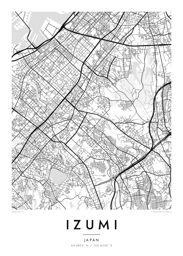
Izumi stretches across southern Osaka Prefecture in the Senshu area, between Sakai and Kishiwada. It is an inland city, so on a map it runs from the flat plain toward the hills instead of along the bay. The northern districts carry the dense street network of the Osaka suburbs. Further south the lines loosen into valleys, terraced slopes and the forested ridges of the Izumi Mountains, which mark the prefectural border.
Rail shapes the city. The JR Hanwa Line crosses the older western districts, and the Semboku Rapid Railway ends at Izumi-Chūō, near the newer planned housing areas. Across the plain, small irrigation ponds are scattered between neighbourhoods. These reservoirs are typical of the Senshu landscape and appear on the map as neat, rounded shapes set among the streets.
An Izumi map poster covers more than a commuter suburb. The Ikegami-Sone site, one of the best-known Yayoi-period settlements in Japan, lies partly within the city. High in the southern hills stands Sefuku-ji on Mount Makinoo, a stop on the Saigoku Kannon pilgrimage. The Kubosō Memorial Museum of Arts is here too, known for its collection of East Asian art.
Dozens of small reservoirs sit among the northern neighbourhoods. They are old farming ponds of the Senshu plain and read as quiet, solid shapes inside the street pattern.
The Semboku Rapid Railway ends at Izumi-Chūō. Around it, the curving roads and larger blocks of planned residential districts contrast with the older grid to the west.
South of the city, roads narrow into valleys that climb toward the Izumi Mountains. The map opens into wide wooded ground on the way up to Mount Makinoo.
Fai mo oe
Faʻaopoopo se aso, se igoa po o sau lava upu, sui le sitaili, lapoʻa po o le itu.
O le preview e leai se totogi e maualalo le resolution ma iai se watermark. O lolomi ma faila HD e faia i le 300 DPI, e oo atu i le 7,200 × 10,800 px, e aunoa ma se watermark.
Aisea Izumi
Izumi suits anyone with ties to southern Osaka: a childhood home near the ponds, a daily train from Izumi-Chūō, or a pilgrimage walk up to Makinoo. From above, the city runs from plain to mountain in one long line, which gives the poster a clear direction.
You can edit the title, subtitle and coordinates line to add a street name, a moving-in date or a family name. Then choose one of five styles: Classic black & white, Noir, Paper, Blueprint or Sand.
Faatau le posita Izumi| Lapoʻa lolomi | Manino | Faila |
|---|---|---|
| 30 × 40 cm11.8 × 15.7″ | 3,543 × 4,724 px | PNG · PDF |
| 29.7 × 42 cm (A3)11.7 × 16.5″ | 3,508 × 4,961 px | PNG · PDF |
| 42 × 59.4 cm (A2)16.5 × 23.4″ | 4,961 × 7,016 px | PNG · PDF |
| 45.7 × 61 cm18 × 24″ | 5,400 × 7,200 px | PNG · PDF |
| 50 × 70 cm19.7 × 27.6″ | 5,906 × 8,268 px | PNG · PDF |
| 61 × 91.4 cm24 × 36″ | 7,200 × 10,800 px | PNG · PDF |
Ae faʻatusatusa, o le faʻataʻitaʻiga e leai se totogi e 900 px le lautele, e iai le faʻailoga vai ma e mo mata. O faila HD e oʻo atu i le 8× le manino i itu taʻitasi ma e lolomi manino i le lapoʻa atoa o le posta.
Filifili se sitaili i le pito i luga o le itulau, ona filifili lea o le Posita Lolomi — se lapopoa ma, afai e te fiafia, se faavaa — po o Faila HD Numera. E na o le tasi laasaga o le Checkout, ma o le a fesuia'i lou itulau o oka i le taimi lava e mae'a ai le totogi.
E lolomiina i luga o pepa matte maualuga le tulaga e 200 gsm, i se tasi o lapopoa e ono, mai le 30 × 40 cm i le 24 × 36″. E amata le tau o posita lolomi mai le $39, aofia ai le auina atu.
Ioe. Filifili se faavaa laau malosi i le lanu uliuli, sina, oak masani, po o le laau pogisa. E aofia ai se tioata e le gau ma ua saunia e tautau i luga. E amata le tau o posita faavaa mai le $99, aofia ai le auina atu.
E leai se totogi o le auina atu i atunuu e 60+. O pepa ata taʻitasi e lolomiina e le tasi o matou paaga lolomi e latalata mai i atunuu e 30+, ma e masani ona taunuu i le 3–7 aso faigaluega. E mafai ona e mulimulitaia le tulaga ma le sailiga i lalo o My Orders. O nisi atunuu e 2–5 vaiaso, ma i nofoaga e lei matou auina atu iai, e taʻu atu e le saite ia te oe a o lei totogi.
Auina mai se ata i totonu o le 14 aso talu ona taunuu, ma o le a matou toe lolomiina e leai se totogi po o le toe faafoi atu lau tupe.
Ioe. I totonu o le editor i lenei itulau, suia le ulutala, le ulutala laititi ma le laina o coordinates i soo se mea e te fiafia i ai, ma filifili se sitaili ma le lapopoa. O oka lolomi, faavaa ma numera e faaaoga uma lava lau mamanu.
Mo le $9 e te maua ai faila PNG 300 DPI ma PDF ua saunia mo le lolomi i lapopoa uma e ono, e aunoa ma se watermark, e mafai ona lolomi i soo se mea. Le mautinoa lava? Download muamua se preview e leai se totogi ma le watermark.
