Reclaimed waterfront grid
The flat strip beside the harbour is laid out in regular blocks. It is a legacy of the 1950s industrial town, and it contrasts with the irregular hillside streets behind it.
Posta faʻafanua faigofie · Hong Kong SAR China
22.3118° N / 114.2218° E
Dense towers on reclaimed land along Victoria Harbour's eastern edge, with steep green hills rising directly behind



Tasi le aai, lagona e lima
Tapi se sitaili e vaai ai i luga o le puipui. E tutusa uma le tau o sitaili — pe lolomiina, faapipiiina, pe avea ma faila HD.
 Pika Moni · Faila Lolomi 24 × 36″
Manino mo le lolomi
O se vaega atoa (100%) lenei mai le faila lolomi moni. O posita uma — pe lolomiina, faapipiiina pe download mai — e faia i luga o a matou server i le 300 DPI, e oo atu i le 7,200 × 10,800 pika, ina ia manino pea auala laiti i luga o se lolomiga 24 × 36″.
I luga o le puipui


Le faʻafanua
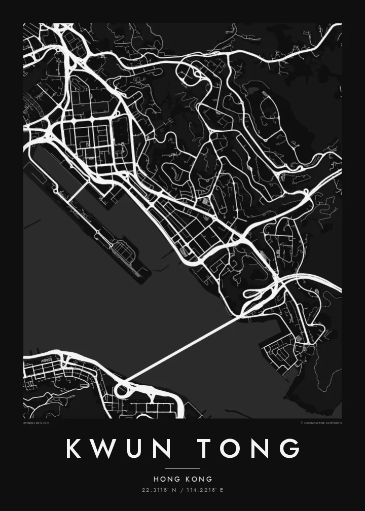
Kwun Tong lies on the eastern side of Kowloon, pressed between the harbour and the hills. From above, the contrast is sharp. Along the shore, a flat strip of reclaimed land is packed with rectangular blocks and wide roads. Inland, the streets climb into housing estates on terraced slopes, and then the built area stops abruptly at the wooded ridges of Kowloon East.
In the 1950s Kwun Tong became one of Hong Kong's first planned industrial towns, laid out on land reclaimed from the harbour. The factory blocks of that era set its regular street pattern. Many have since become offices, and the area is now part of the Kowloon East business district. Today the waterfront has a promenade facing the former Kai Tak runway across the water.
On the map, the elevated MTR line and Kwun Tong Road run parallel to the shore like two strong strokes. The Kwun Tong Bypass traces the water's edge. The Kwun Tong map poster captures this layering of sea, flat industrial grid, steep estates and open hillside, all within a few kilometres.
The flat strip beside the harbour is laid out in regular blocks. It is a legacy of the 1950s industrial town, and it contrasts with the irregular hillside streets behind it.
The MTR Kwun Tong Line, Kwun Tong Road and the bypass run side by side along the shore. They form strong linear bands across the composition.
Across a narrow channel, the long finger of the former Kai Tak airport runway points into the harbour. It gives the waterfront a distinctive frame.
Fai mo oe
Faʻaopoopo se aso, se igoa po o sau lava upu, sui le sitaili, lapoʻa po o le itu.
O le preview e leai se totogi e maualalo le resolution ma iai se watermark. O lolomi ma faila HD e faia i le 300 DPI, e oo atu i le 7,200 × 10,800 px, e aunoa ma se watermark.
Aisea Kwun Tong
Kwun Tong is where many Hong Kong people have worked, grown up in a public housing estate or started a first job in a converted factory building. A map of it is both a practical reminder and a portrait of how the city reshaped its coastline.
Add an estate name, a street or a date to the title and subtitle, and set the coordinates line. Choose from five styles. Noir and Blueprint suit the dense urban grid, and Classic black & white keeps the harbour edge crisp.
Faatau le posita Kwun Tong| Lapoʻa lolomi | Manino | Faila |
|---|---|---|
| 30 × 40 cm11.8 × 15.7″ | 3,543 × 4,724 px | PNG · PDF |
| 29.7 × 42 cm (A3)11.7 × 16.5″ | 3,508 × 4,961 px | PNG · PDF |
| 42 × 59.4 cm (A2)16.5 × 23.4″ | 4,961 × 7,016 px | PNG · PDF |
| 45.7 × 61 cm18 × 24″ | 5,400 × 7,200 px | PNG · PDF |
| 50 × 70 cm19.7 × 27.6″ | 5,906 × 8,268 px | PNG · PDF |
| 61 × 91.4 cm24 × 36″ | 7,200 × 10,800 px | PNG · PDF |
Ae faʻatusatusa, o le faʻataʻitaʻiga e leai se totogi e 900 px le lautele, e iai le faʻailoga vai ma e mo mata. O faila HD e oʻo atu i le 8× le manino i itu taʻitasi ma e lolomi manino i le lapoʻa atoa o le posta.
Filifili se sitaili i le pito i luga o le itulau, ona filifili lea o le Posita Lolomi — se lapopoa ma, afai e te fiafia, se faavaa — po o Faila HD Numera. E na o le tasi laasaga o le Checkout, ma o le a fesuia'i lou itulau o oka i le taimi lava e mae'a ai le totogi.
E lolomiina i luga o pepa matte maualuga le tulaga e 200 gsm, i se tasi o lapopoa e ono, mai le 30 × 40 cm i le 24 × 36″. E amata le tau o posita lolomi mai le $39, aofia ai le auina atu.
Ioe. Filifili se faavaa laau malosi i le lanu uliuli, sina, oak masani, po o le laau pogisa. E aofia ai se tioata e le gau ma ua saunia e tautau i luga. E amata le tau o posita faavaa mai le $99, aofia ai le auina atu.
E leai se totogi o le auina atu i atunuu e 60+. O pepa ata taʻitasi e lolomiina e le tasi o matou paaga lolomi e latalata mai i atunuu e 30+, ma e masani ona taunuu i le 3–7 aso faigaluega. E mafai ona e mulimulitaia le tulaga ma le sailiga i lalo o My Orders. O nisi atunuu e 2–5 vaiaso, ma i nofoaga e lei matou auina atu iai, e taʻu atu e le saite ia te oe a o lei totogi.
Auina mai se ata i totonu o le 14 aso talu ona taunuu, ma o le a matou toe lolomiina e leai se totogi po o le toe faafoi atu lau tupe.
Ioe. I totonu o le editor i lenei itulau, suia le ulutala, le ulutala laititi ma le laina o coordinates i soo se mea e te fiafia i ai, ma filifili se sitaili ma le lapopoa. O oka lolomi, faavaa ma numera e faaaoga uma lava lau mamanu.
Mo le $9 e te maua ai faila PNG 300 DPI ma PDF ua saunia mo le lolomi i lapopoa uma e ono, e aunoa ma se watermark, e mafai ona lolomi i soo se mea. Le mautinoa lava? Download muamua se preview e leai se totogi ma le watermark.
