Nieuwe Waterweg
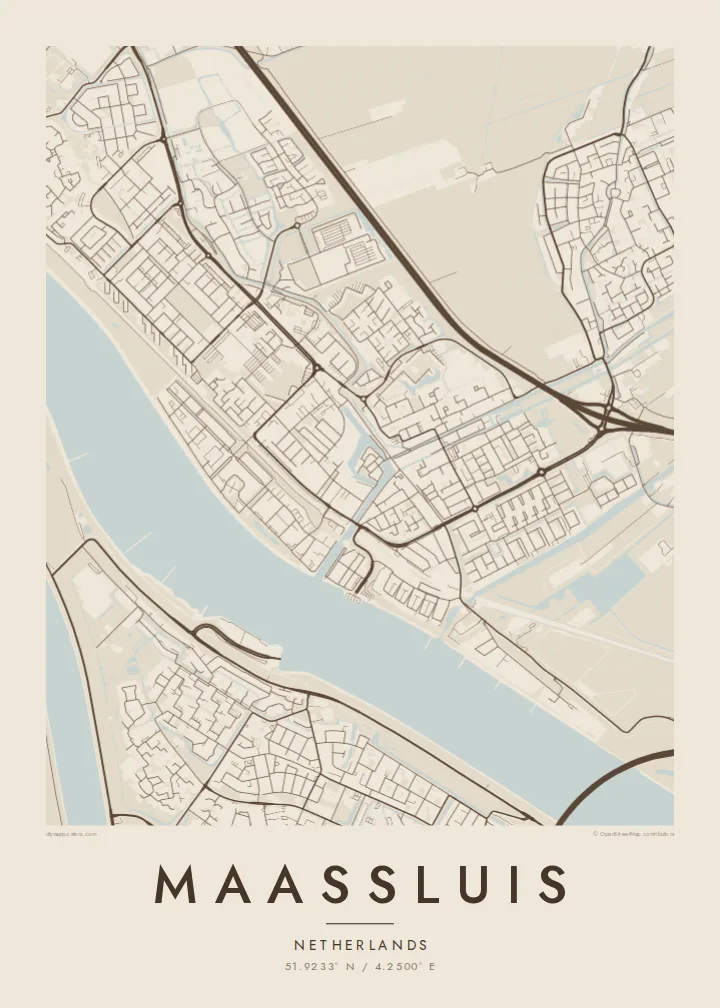
The wide shipping channel runs along the town's southern side, one of the busiest waterways in Europe, and forms a bold band across the bottom of the poster.
Posta faʻafanua faigofie · Netherlands
51.9233° N / 4.2500° E
A harbour town on the Nieuwe Waterweg, with an old sluice-side core, straight dikes and polders opening behind the river.


Tasi le aai, lagona e lima
Tapi se sitaili e vaai ai i luga o le puipui. E tutusa uma le tau o sitaili — pe lolomiina, faapipiiina, pe avea ma faila HD.
 Pika Moni · Faila Lolomi 24 × 36″
Manino mo le lolomi
O se vaega atoa (100%) lenei mai le faila lolomi moni. O posita uma — pe lolomiina, faapipiiina pe download mai — e faia i luga o a matou server i le 300 DPI, e oo atu i le 7,200 × 10,800 pika, ina ia manino pea auala laiti i luga o se lolomiga 24 × 36″.
I luga o le puipui


Le faʻafanua
Maassluis sits on the north bank of the Nieuwe Waterweg, the wide shipping channel that links Rotterdam to the North Sea. From above, the river forms a broad, dark band along the southern edge of the town. The old harbour cuts inland from it, surrounded by the tight streets of the historic centre, and the rest of the town extends north into the flat Dutch polder landscape.
The name refers to the sluice that once let water from the polders drain into the river. Water management still sets the pattern here, with dikes, ditches and straight drainage lines across the surrounding land. The town has long been associated with tugboats and maritime work, and ships moving to and from Rotterdam pass close to its quays.
A Maassluis map poster shows the contrast between that major waterway and the small, careful street network behind it. The harbour basin, the dike roads and the geometric polder edges produce a map with clean straight lines and one strong horizontal river. It is Dutch landscape design seen from above.
The wide shipping channel runs along the town's southern side, one of the busiest waterways in Europe, and forms a bold band across the bottom of the poster.
A narrow basin reaches inland from the river into the historic centre. The oldest streets and quays cluster close around it in a small, dense pattern.
North of the built-up area, straight ditches and roads divide the reclaimed land into long rectangles, a pattern typical of South Holland that looks crisp in black and white.
Fai mo oe
Faʻaopoopo se aso, se igoa po o sau lava upu, sui le sitaili, lapoʻa po o le itu.
O le preview e leai se totogi e maualalo le resolution ma iai se watermark. O lolomi ma faila HD e faia i le 300 DPI, e oo atu i le 7,200 × 10,800 px, e aunoa ma se watermark.
Aisea Maassluis
If you have lived by the Waterweg and watched ships pass behind the dike, this map will look familiar. It also appeals to anyone who likes how the Dutch have drawn their land with rulers and water.
Personalise the title, subtitle and coordinates, perhaps with a harbour name or the year of a move. The five styles range from Classic black & white to Noir, which gives the river a deep, dark presence.
Faatau le posita Maassluis| Lapoʻa lolomi | Manino | Faila |
|---|---|---|
| 30 × 40 cm11.8 × 15.7″ | 3,543 × 4,724 px | PNG · PDF |
| 29.7 × 42 cm (A3)11.7 × 16.5″ | 3,508 × 4,961 px | PNG · PDF |
| 42 × 59.4 cm (A2)16.5 × 23.4″ | 4,961 × 7,016 px | PNG · PDF |
| 45.7 × 61 cm18 × 24″ | 5,400 × 7,200 px | PNG · PDF |
| 50 × 70 cm19.7 × 27.6″ | 5,906 × 8,268 px | PNG · PDF |
| 61 × 91.4 cm24 × 36″ | 7,200 × 10,800 px | PNG · PDF |
Ae faʻatusatusa, o le faʻataʻitaʻiga e leai se totogi e 900 px le lautele, e iai le faʻailoga vai ma e mo mata. O faila HD e oʻo atu i le 8× le manino i itu taʻitasi ma e lolomi manino i le lapoʻa atoa o le posta.
Filifili se sitaili i le pito i luga o le itulau, ona filifili lea o le Posita Lolomi — se lapopoa ma, afai e te fiafia, se faavaa — po o Faila HD Numera. E na o le tasi laasaga o le Checkout, ma o le a fesuia'i lou itulau o oka i le taimi lava e mae'a ai le totogi.
E lolomiina i luga o pepa matte maualuga le tulaga e 200 gsm, i se tasi o lapopoa e ono, mai le 30 × 40 cm i le 24 × 36″. E amata le tau o posita lolomi mai le $39, aofia ai le auina atu.
Ioe. Filifili se faavaa laau malosi i le lanu uliuli, sina, oak masani, po o le laau pogisa. E aofia ai se tioata e le gau ma ua saunia e tautau i luga. E amata le tau o posita faavaa mai le $99, aofia ai le auina atu.
E leai se totogi o le auina atu i atunuu e 60+. O pepa ata taʻitasi e lolomiina e le tasi o matou paaga lolomi e latalata mai i atunuu e 30+, ma e masani ona taunuu i le 3–7 aso faigaluega. E mafai ona e mulimulitaia le tulaga ma le sailiga i lalo o My Orders. O nisi atunuu e 2–5 vaiaso, ma i nofoaga e lei matou auina atu iai, e taʻu atu e le saite ia te oe a o lei totogi.
Auina mai se ata i totonu o le 14 aso talu ona taunuu, ma o le a matou toe lolomiina e leai se totogi po o le toe faafoi atu lau tupe.
Ioe. I totonu o le editor i lenei itulau, suia le ulutala, le ulutala laititi ma le laina o coordinates i soo se mea e te fiafia i ai, ma filifili se sitaili ma le lapopoa. O oka lolomi, faavaa ma numera e faaaoga uma lava lau mamanu.
Mo le $9 e te maua ai faila PNG 300 DPI ma PDF ua saunia mo le lolomi i lapopoa uma e ono, e aunoa ma se watermark, e mafai ona lolomi i soo se mea. Le mautinoa lava? Download muamua se preview e leai se totogi ma le watermark.
Latalata ane
