Ming city wall
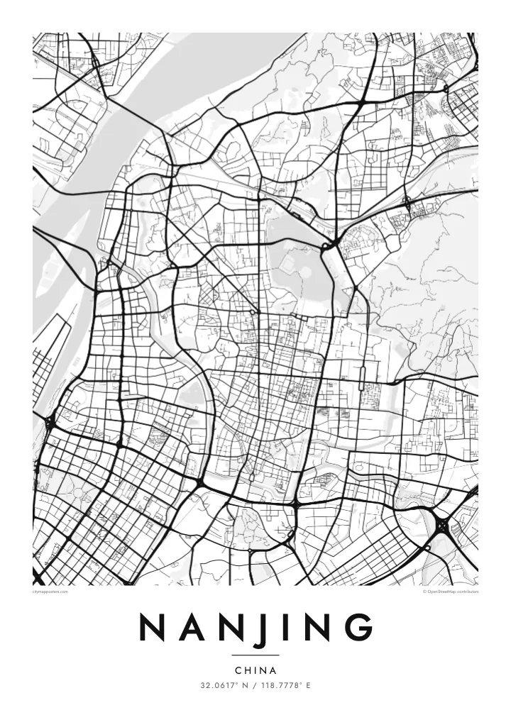
One of the longest surviving city walls in the world, following ridges and lakeshores for more than twenty kilometres. On the poster it forms an irregular loop around the historic core.
Posta faʻafanua faigofie · China
32.0617° N / 118.7778° E
The Yangtze sweeping past a Ming-walled city, with Xuanwu Lake pressed against the wall and Purple Mountain rising east.


Tasi le aai, lagona e lima
Tapi se sitaili e vaai ai i luga o le puipui. E tutusa uma le tau o sitaili — pe lolomiina, faapipiiina, pe avea ma faila HD.
 Pika Moni · Faila Lolomi 24 × 36″
Manino mo le lolomi
O se vaega atoa (100%) lenei mai le faila lolomi moni. O posita uma — pe lolomiina, faapipiiina pe download mai — e faia i luga o a matou server i le 300 DPI, e oo atu i le 7,200 × 10,800 pika, ina ia manino pea auala laiti i luga o se lolomiga 24 × 36″.
I luga o le puipui


Le faʻafanua
Nanjing lies on the southern bank of the Yangtze, where the river turns northeast, and the city has faced the water for well over two thousand years. Its most distinctive feature from above is the Ming city wall, built in the fourteenth century and still standing along much of its length. The line bends irregularly around hills and lakes rather than forming a neat rectangle.
Inside and around the wall, the city is full of water. Xuanwu Lake lies just beyond the northern stretch, the Qinhuai River curves through the south past the Confucius Temple district, and moats follow the old fortifications. East of the centre, Purple Mountain carries the Sun Yat-sen Mausoleum and the Ming Xiaoling tomb within a large forested area, which reads as open space on the map.
Nanjing served as the capital of China under several dynasties and governments, which explains its ceremonial avenues and monumental gates. Zhonghua Gate in the south is one of the largest surviving city gates in China. A Nanjing map poster frames the river, the wall and the mountain together, the three features most often cited in explaining why the city was chosen as a capital.
One of the longest surviving city walls in the world, following ridges and lakeshores for more than twenty kilometres. On the poster it forms an irregular loop around the historic core.
The river that loops through southern Nanjing, running both outside and inside the wall, past the Confucius Temple and its old lanes. Its bends define the southern edge of the old city.
The forested mountain east of the walls holds the Sun Yat-sen Mausoleum, the Ming Xiaoling tomb and an observatory. On the map it appears as a large, calm area of paths and slopes.
Fai mo oe
Faʻaopoopo se aso, se igoa po o sau lava upu, sui le sitaili, lapoʻa po o le itu.
O le preview e leai se totogi e maualalo le resolution ma iai se watermark. O lolomi ma faila HD e faia i le 300 DPI, e oo atu i le 7,200 × 10,800 px, e aunoa ma se watermark.
Aisea Nanjing
Nanjing is a city people study in, and many graduates of its universities carry a lasting attachment to its plane-tree avenues and old gates. A map of the walled city is a way of keeping those years in view, long after leaving.
Set your own title and subtitle, perhaps a graduation year, and edit the coordinates line if you like. Choose from five styles; Paper and Sand suit the old wall, Blueprint the river crossings. Order the HD files or a matte print with an optional wooden frame.
Faatau le posita Nanjing| Lapoʻa lolomi | Manino | Faila |
|---|---|---|
| 30 × 40 cm11.8 × 15.7″ | 3,543 × 4,724 px | PNG · PDF |
| 29.7 × 42 cm (A3)11.7 × 16.5″ | 3,508 × 4,961 px | PNG · PDF |
| 42 × 59.4 cm (A2)16.5 × 23.4″ | 4,961 × 7,016 px | PNG · PDF |
| 45.7 × 61 cm18 × 24″ | 5,400 × 7,200 px | PNG · PDF |
| 50 × 70 cm19.7 × 27.6″ | 5,906 × 8,268 px | PNG · PDF |
| 61 × 91.4 cm24 × 36″ | 7,200 × 10,800 px | PNG · PDF |
Ae faʻatusatusa, o le faʻataʻitaʻiga e leai se totogi e 900 px le lautele, e iai le faʻailoga vai ma e mo mata. O faila HD e oʻo atu i le 8× le manino i itu taʻitasi ma e lolomi manino i le lapoʻa atoa o le posta.
Filifili se sitaili i le pito i luga o le itulau, ona filifili lea o le Posita Lolomi — se lapopoa ma, afai e te fiafia, se faavaa — po o Faila HD Numera. E na o le tasi laasaga o le Checkout, ma o le a fesuia'i lou itulau o oka i le taimi lava e mae'a ai le totogi.
E lolomiina i luga o pepa matte maualuga le tulaga e 200 gsm, i se tasi o lapopoa e ono, mai le 30 × 40 cm i le 24 × 36″. E amata le tau o posita lolomi mai le $39, aofia ai le auina atu.
Ioe. Filifili se faavaa laau malosi i le lanu uliuli, sina, oak masani, po o le laau pogisa. E aofia ai se tioata e le gau ma ua saunia e tautau i luga. E amata le tau o posita faavaa mai le $99, aofia ai le auina atu.
E leai se totogi o le auina atu i atunuu e 60+. O pepa ata taʻitasi e lolomiina e le tasi o matou paaga lolomi e latalata mai i atunuu e 30+, ma e masani ona taunuu i le 3–7 aso faigaluega. E mafai ona e mulimulitaia le tulaga ma le sailiga i lalo o My Orders. O nisi atunuu e 2–5 vaiaso, ma i nofoaga e lei matou auina atu iai, e taʻu atu e le saite ia te oe a o lei totogi.
Auina mai se ata i totonu o le 14 aso talu ona taunuu, ma o le a matou toe lolomiina e leai se totogi po o le toe faafoi atu lau tupe.
Ioe. I totonu o le editor i lenei itulau, suia le ulutala, le ulutala laititi ma le laina o coordinates i soo se mea e te fiafia i ai, ma filifili se sitaili ma le lapopoa. O oka lolomi, faavaa ma numera e faaaoga uma lava lau mamanu.
Mo le $9 e te maua ai faila PNG 300 DPI ma PDF ua saunia mo le lolomi i lapopoa uma e ono, e aunoa ma se watermark, e mafai ona lolomi i soo se mea. Le mautinoa lava? Download muamua se preview e leai se totogi ma le watermark.
Latalata ane
