The national road
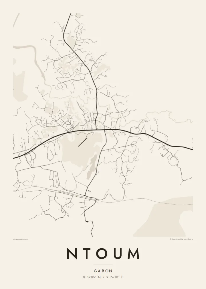
The main highway heading east from Libreville forms the backbone of the map. Nearly every other street connects back to it, so the line of the road organises the whole composition.
Posta faʻafanua faigofie · Gabon
0.3905° N / 9.7610° E
A roadside town east of Libreville, its streets strung along the national road and pressed in by equatorial forest




Tasi le aai, lagona e lima
Tapi se sitaili e vaai ai i luga o le puipui. E tutusa uma le tau o sitaili — pe lolomiina, faapipiiina, pe avea ma faila HD.
 Pika Moni · Faila Lolomi 24 × 36″
Manino mo le lolomi
O se vaega atoa (100%) lenei mai le faila lolomi moni. O posita uma — pe lolomiina, faapipiiina pe download mai — e faia i luga o a matou server i le 300 DPI, e oo atu i le 7,200 × 10,800 pika, ina ia manino pea auala laiti i luga o se lolomiga 24 × 36″.
I luga o le puipui


Le faʻafanua
Ntoum sits in Gabon's Estuaire province, a short drive east of Libreville and only a few dozen kilometres north of the equator. On a map it reads as a settlement shaped by a road: the main national route runs through it, and the town has grown along that line rather than around a single centre, with side streets branching off into cleared ground and then stopping where the forest resumes.
That relationship between built area and green mass is what gives the drawing its character. Roads thin out quickly, tracks wander toward small streams, and the blocks near the main route are denser than anywhere else. Printed in black and white, the town becomes a spine with ribs, a clear record of how a commuter settlement forms at the edge of a capital region.
A Ntoum map poster suits someone with a personal link to the place, whether they grew up there, work on the Libreville side of the estuary or passed through on the way inland. The composition is quiet and linear, with plenty of open space around the street network, which keeps the print calm on a wall and lets the title and coordinates carry the story.
The main highway heading east from Libreville forms the backbone of the map. Nearly every other street connects back to it, so the line of the road organises the whole composition.
Beyond the last blocks the street network simply stops. On the poster that boundary shows as an irregular margin of empty paper where cleared land gives way to forest.
At roughly 0.39 degrees north, Ntoum lies less than fifty kilometres from the equator, a detail the coordinates line on the poster records precisely.
Fai mo oe
Faʻaopoopo se aso, se igoa po o sau lava upu, sui le sitaili, lapoʻa po o le itu.
O le preview e leai se totogi e maualalo le resolution ma iai se watermark. O lolomi ma faila HD e faia i le 300 DPI, e oo atu i le 7,200 × 10,800 px, e aunoa ma se watermark.
Aisea Ntoum
People hang Ntoum as a marker of home or of a working life tied to the Libreville region. The map is not crowded with famous landmarks; it shows the real structure of a growing town, which makes it feel honest and specific rather than decorative.
You can set your own title, subtitle and coordinates line, adding a family name, a date or a short phrase, and choose between five styles: Classic black & white, Noir, Paper, Blueprint and Sand. Download the HD files for $9 or order a printed poster, framed or unframed.
Faatau le posita Ntoum| Lapoʻa lolomi | Manino | Faila |
|---|---|---|
| 30 × 40 cm (11.8 × 15.7″) | 3,543 × 4,724 px | PNG · PDF |
| 29.7 × 42 cm (A3, 11.7 × 16.5″) | 3,508 × 4,961 px | PNG · PDF |
| 42 × 59.4 cm (A2, 16.5 × 23.4″) | 4,961 × 7,016 px | PNG · PDF |
| 45.7 × 61 cm (18 × 24″) | 5,400 × 7,200 px | PNG · PDF |
| 50 × 70 cm (19.7 × 27.6″) | 5,906 × 8,268 px | PNG · PDF |
| 61 × 91.4 cm (24 × 36″) | 7,200 × 10,800 px | PNG · PDF |
Ae faʻatusatusa, o le faʻataʻitaʻiga e leai se totogi e 900 px le lautele, e iai le faʻailoga vai ma e mo mata. O faila HD e oʻo atu i le 8× le manino i itu taʻitasi ma e lolomi manino i le lapoʻa atoa o le posta.
Filifili se sitaili i le pito i luga o le itulau, ona filifili lea o le Posita Lolomi — se lapopoa ma, afai e te fiafia, se faavaa — po o Faila HD Numera. E na o le tasi laasaga o le Checkout, ma o le a fesuia'i lou itulau o oka i le taimi lava e mae'a ai le totogi.
E lolomiina i luga o pepa matte maualuga le tulaga e 200 gsm, i se tasi o lapopoa e ono, mai le 30 × 40 cm i le 24 × 36″. E amata le tau o posita lolomi mai le $39, aofia ai le auina atu.
Ioe. Filifili se faavaa laau malosi i le lanu uliuli, sina, oak masani, po o le laau pogisa. E aofia ai se tioata e le gau ma ua saunia e tautau i luga. E amata le tau o posita faavaa mai le $99, aofia ai le auina atu.
E leai se totogi mo le uta i le lalolagi atoa. O poster ta'itasi e lolomi e le paaga lolomi e latalata mai i matou i atunuu e 30+, ma e masani ona taunuu i aso faigaluega e 3–7. E mafai ona e mulimuli i le tulaga ma le tracking i le "Aʻu Oka". O nisi atunuu e 2–5 vaiaso, ma i atunuu matou te lei tuuina atu ai, e taʻu atu e le saite iā te oe ae e te leʻi totogiina.
Auina mai se ata i totonu o le 14 aso talu ona taunuu, ma o le a matou toe lolomiina e leai se totogi po o le toe faafoi atu lau tupe.
Ioe. I totonu o le editor i lenei itulau, suia le ulutala, le ulutala laititi ma le laina o coordinates i soo se mea e te fiafia i ai, ma filifili se sitaili ma le lapopoa. O oka lolomi, faavaa ma numera e faaaoga uma lava lau mamanu.
Mo le $9 e te maua ai faila PNG 300 DPI ma PDF ua saunia mo le lolomi i lapopoa uma e ono, e aunoa ma se watermark, e mafai ona lolomi i soo se mea. Le mautinoa lava? Download muamua se preview e leai se totogi ma le watermark.
