Oude Maas bend
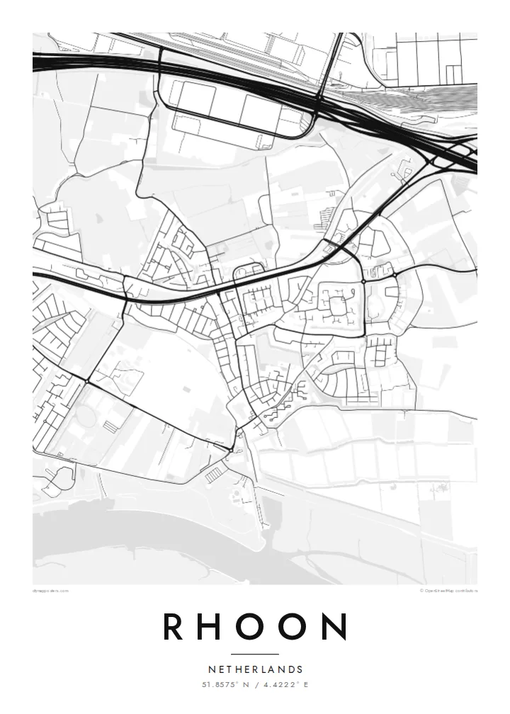
The broad tidal river sweeps along the southern side of Rhoon, and its smooth curve gives the map a strong natural edge.
Posta faʻafanua faigofie · Netherlands
51.8575° N / 4.4222° E
A village on the Oude Maas south of Rotterdam, framed by river bends, polders and willow marshes.


Tasi le aai, lagona e lima
Tapi se sitaili e vaai ai i luga o le puipui. E tutusa uma le tau o sitaili — pe lolomiina, faapipiiina, pe avea ma faila HD.
 Pika Moni · Faila Lolomi 24 × 36″
Manino mo le lolomi
O se vaega atoa (100%) lenei mai le faila lolomi moni. O posita uma — pe lolomiina, faapipiiina pe download mai — e faia i luga o a matou server i le 300 DPI, e oo atu i le 7,200 × 10,800 pika, ina ia manino pea auala laiti i luga o se lolomiga 24 × 36″.
I luga o le puipui


Le faʻafanua
Rhoon is part of the municipality of Albrandswaard, on the island of IJsselmonde just south of Rotterdam. The map shows a place in two parts: the older village near the dike along the Oude Maas, and newer residential districts laid out in curving streets and cul-de-sacs further inland. Around them lie flat polders crossed by straight ditches, typical of the South Holland landscape.
The historic core centres on Kasteel Rhoon, a small castle that now serves as a restaurant and venue, close to the village church. Along the river, the Rhoonse Grienden form an area of tidal willow woodland and creeks. It is one of the more unusual green shapes on the map, where water, trees and paths intertwine.
Infrastructure draws sharp lines at the edges. Motorways and the Rotterdam metro connect Rhoon to the city, and the river curves past in a wide, confident arc. A Rhoon map poster sets these elements against each other: engineered transport routes, geometric polders and a river edge softened by marsh and woodland.
The broad tidal river sweeps along the southern side of Rhoon, and its smooth curve gives the map a strong natural edge.
Willow woodland threaded with creeks and footpaths lines the river, drawing an intricate, organic pattern between the dike and the water.
Straight drainage ditches divide the surrounding farmland into long, narrow parcels, a quietly rhythmic texture typical of the Dutch low country.
Fai mo oe
Faʻaopoopo se aso, se igoa po o sau lava upu, sui le sitaili, lapoʻa po o le itu.
O le preview e leai se totogi e maualalo le resolution ma iai se watermark. O lolomi ma faila HD e faia i le 300 DPI, e oo atu i le 7,200 × 10,800 px, e aunoa ma se watermark.
Aisea Rhoon
A map of Rhoon appeals to people who know the village as home, as a first house near the city or as a place for walks along the river. The flat landscape translates well into line art, where every ditch and dike becomes part of the design.
Choose your own title and subtitle, for example a street name and the year you moved in, and keep or edit the coordinates line. Pick Classic black & white, Noir, Paper, Blueprint or Sand, as instant HD files or as a printed poster.
Faatau le posita Rhoon| Lapoʻa lolomi | Manino | Faila |
|---|---|---|
| 30 × 40 cm (11.8 × 15.7″) | 3,543 × 4,724 px | PNG · PDF |
| 29.7 × 42 cm (A3, 11.7 × 16.5″) | 3,508 × 4,961 px | PNG · PDF |
| 42 × 59.4 cm (A2, 16.5 × 23.4″) | 4,961 × 7,016 px | PNG · PDF |
| 45.7 × 61 cm (18 × 24″) | 5,400 × 7,200 px | PNG · PDF |
| 50 × 70 cm (19.7 × 27.6″) | 5,906 × 8,268 px | PNG · PDF |
| 61 × 91.4 cm (24 × 36″) | 7,200 × 10,800 px | PNG · PDF |
Ae faʻatusatusa, o le faʻataʻitaʻiga e leai se totogi e 900 px le lautele, e iai le faʻailoga vai ma e mo mata. O faila HD e oʻo atu i le 8× le manino i itu taʻitasi ma e lolomi manino i le lapoʻa atoa o le posta.
Filifili se sitaili i le pito i luga o le itulau, ona filifili lea o le Posita Lolomi — se lapopoa ma, afai e te fiafia, se faavaa — po o Faila HD Numera. E na o le tasi laasaga o le Checkout, ma o le a fesuia'i lou itulau o oka i le taimi lava e mae'a ai le totogi.
E lolomiina i luga o pepa matte maualuga le tulaga e 200 gsm, i se tasi o lapopoa e ono, mai le 30 × 40 cm i le 24 × 36″. E amata le tau o posita lolomi mai le $39, aofia ai le auina atu.
Ioe. Filifili se faavaa laau malosi i le lanu uliuli, sina, oak masani, po o le laau pogisa. E aofia ai se tioata e le gau ma ua saunia e tautau i luga. E amata le tau o posita faavaa mai le $99, aofia ai le auina atu.
E leai se totogi mo le uta i le lalolagi atoa. O poster ta'itasi e lolomi e le paaga lolomi e latalata mai i matou i atunuu e 30+, ma e masani ona taunuu i aso faigaluega e 3–7. E mafai ona e mulimuli i le tulaga ma le tracking i le "Aʻu Oka". O nisi atunuu e 2–5 vaiaso, ma i atunuu matou te lei tuuina atu ai, e taʻu atu e le saite iā te oe ae e te leʻi totogiina.
Auina mai se ata i totonu o le 14 aso talu ona taunuu, ma o le a matou toe lolomiina e leai se totogi po o le toe faafoi atu lau tupe.
Ioe. I totonu o le editor i lenei itulau, suia le ulutala, le ulutala laititi ma le laina o coordinates i soo se mea e te fiafia i ai, ma filifili se sitaili ma le lapopoa. O oka lolomi, faavaa ma numera e faaaoga uma lava lau mamanu.
Mo le $9 e te maua ai faila PNG 300 DPI ma PDF ua saunia mo le lolomi i lapopoa uma e ono, e aunoa ma se watermark, e mafai ona lolomi i soo se mea. Le mautinoa lava? Download muamua se preview e leai se totogi ma le watermark.
