The Váh river
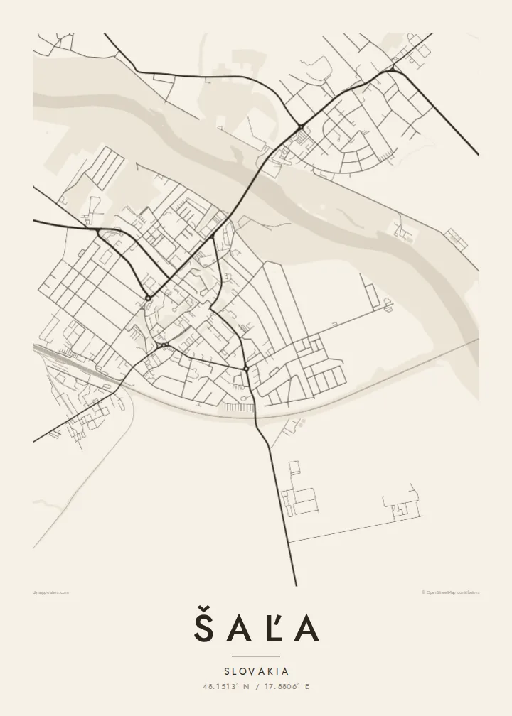
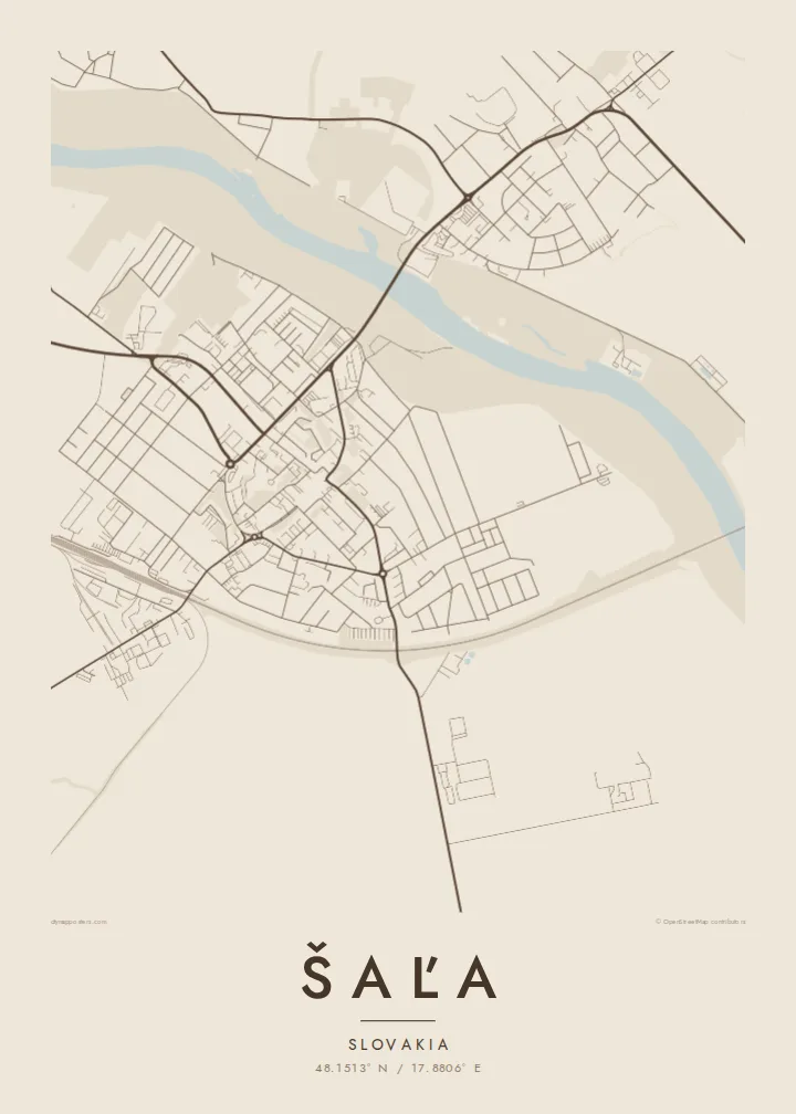
The Váh curves through the lowland and divides Šaľa in two. Its wide channel and the bridges across it form the strongest line on the poster, dark against the pale street pattern.
Posta faʻafanua faigofie · Slovakia
48.1513° N / 17.8806° E
A compact lowland town drawn along the curve of the Váh, with bridges tying the centre to Veča on the opposite bank.



Tasi le aai, lagona e lima
Tapi se sitaili e vaai ai i luga o le puipui. E tutusa uma le tau o sitaili — pe lolomiina, faapipiiina, pe avea ma faila HD.
 Pika Moni · Faila Lolomi 24 × 36″
Manino mo le lolomi
O se vaega atoa (100%) lenei mai le faila lolomi moni. O posita uma — pe lolomiina, faapipiiina pe download mai — e faia i luga o a matou server i le 300 DPI, e oo atu i le 7,200 × 10,800 pika, ina ia manino pea auala laiti i luga o se lolomiga 24 × 36″.
I luga o le puipui


Le faʻafanua
Šaľa sits on the flat Danubian Lowland in the Nitra Region, and on a map the Váh is the first thing the eye follows. The river bends past the town in a broad, unhurried line and splits the built-up area in two: the main centre on one bank and the district of Veča on the other. Around them the land opens into large rectangular fields that run almost to the horizon.
Šaľa has one of the oldest written records of any town in Slovakia, with a first mention in a charter dated 1002. That long timeline is not obvious in the street pattern, which was mostly shaped in the twentieth century: housing estates, straight avenues and a railway line crossing the plain. The contrast between the river's curve and the geometry of the streets gives the map its character.
Šaľa is also home to Duslo, one of the largest chemical producers in the country, and its industrial site shows on the map as a block of large, regular shapes at the edge of town. A Šaľa map poster keeps all of this in black and white, so the river, the estates, the plant and the fields read together as one clean drawing.
The Váh curves through the lowland and divides Šaľa in two. Its wide channel and the bridges across it form the strongest line on the poster, dark against the pale street pattern.
On the opposite bank, Veča forms a second cluster of streets. Seen from above it balances the main centre, so the town reads as a pair rather than a single block.
Beyond the last houses the Danubian Lowland stretches out in long, rectangular plots. Their straight edges frame the town and give the composition a quiet, measured border.
Fai mo oe
Faʻaopoopo se aso, se igoa po o sau lava upu, sui le sitaili, lapoʻa po o le itu.
O le preview e leai se totogi e maualalo le resolution ma iai se watermark. O lolomi ma faila HD e faia i le 300 DPI, e oo atu i le 7,200 × 10,800 px, e aunoa ma se watermark.
Aisea Šaľa
People who grew up in Šaľa, or who crossed the Váh every day on the way to school or work, often want a map that shows the whole town at once. The river's curve makes a strong central motif for a wall above a desk or in a hallway.
You can set your own title, subtitle and coordinates line, adding a family name or a meaningful date, and choose from five styles: Classic black & white, Noir, Paper, Blueprint or Sand. The $9 digital files include six print sizes as 300 DPI PNG and print-ready PDF.
Faatau le posita Šaľa| Lapoʻa lolomi | Manino | Faila |
|---|---|---|
| 30 × 40 cm (11.8 × 15.7″) | 3,543 × 4,724 px | PNG · PDF |
| 29.7 × 42 cm (A3, 11.7 × 16.5″) | 3,508 × 4,961 px | PNG · PDF |
| 42 × 59.4 cm (A2, 16.5 × 23.4″) | 4,961 × 7,016 px | PNG · PDF |
| 45.7 × 61 cm (18 × 24″) | 5,400 × 7,200 px | PNG · PDF |
| 50 × 70 cm (19.7 × 27.6″) | 5,906 × 8,268 px | PNG · PDF |
| 61 × 91.4 cm (24 × 36″) | 7,200 × 10,800 px | PNG · PDF |
Ae faʻatusatusa, o le faʻataʻitaʻiga e leai se totogi e 900 px le lautele, e iai le faʻailoga vai ma e mo mata. O faila HD e oʻo atu i le 8× le manino i itu taʻitasi ma e lolomi manino i le lapoʻa atoa o le posta.
Filifili se sitaili i le pito i luga o le itulau, ona filifili lea o le Posita Lolomi — se lapopoa ma, afai e te fiafia, se faavaa — po o Faila HD Numera. E na o le tasi laasaga o le Checkout, ma o le a fesuia'i lou itulau o oka i le taimi lava e mae'a ai le totogi.
E lolomiina i luga o pepa matte maualuga le tulaga e 200 gsm, i se tasi o lapopoa e ono, mai le 30 × 40 cm i le 24 × 36″. E amata le tau o posita lolomi mai le $39, aofia ai le auina atu.
Ioe. Filifili se faavaa laau malosi i le lanu uliuli, sina, oak masani, po o le laau pogisa. E aofia ai se tioata e le gau ma ua saunia e tautau i luga. E amata le tau o posita faavaa mai le $99, aofia ai le auina atu.
E leai se totogi mo le uta i le lalolagi atoa. O poster ta'itasi e lolomi e le paaga lolomi e latalata mai i matou i atunuu e 30+, ma e masani ona taunuu i aso faigaluega e 3–7. E mafai ona e mulimuli i le tulaga ma le tracking i le "Aʻu Oka". O nisi atunuu e 2–5 vaiaso, ma i atunuu matou te lei tuuina atu ai, e taʻu atu e le saite iā te oe ae e te leʻi totogiina.
Auina mai se ata i totonu o le 14 aso talu ona taunuu, ma o le a matou toe lolomiina e leai se totogi po o le toe faafoi atu lau tupe.
Ioe. I totonu o le editor i lenei itulau, suia le ulutala, le ulutala laititi ma le laina o coordinates i soo se mea e te fiafia i ai, ma filifili se sitaili ma le lapopoa. O oka lolomi, faavaa ma numera e faaaoga uma lava lau mamanu.
Mo le $9 e te maua ai faila PNG 300 DPI ma PDF ua saunia mo le lolomi i lapopoa uma e ono, e aunoa ma se watermark, e mafai ona lolomi i soo se mea. Le mautinoa lava? Download muamua se preview e leai se totogi ma le watermark.
