The Manning River
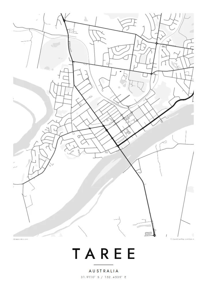
A broad, curving river that shapes the whole town. On the poster it reads as the heaviest form on the sheet, with the town centre pressed against its northern bank.
Posta faʻafanua faigofie · Australia
31.9110° S / 152.4539° E
A river town on the Manning, its streets laid out along a broad bend with farmland and floodplain on every side


Tasi le aai, lagona e lima
Tapi se sitaili e vaai ai i luga o le puipui. E tutusa uma le tau o sitaili — pe lolomiina, faapipiiina, pe avea ma faila HD.
 Pika Moni · Faila Lolomi 24 × 36″
Manino mo le lolomi
O se vaega atoa (100%) lenei mai le faila lolomi moni. O posita uma — pe lolomiina, faapipiiina pe download mai — e faia i luga o a matou server i le 300 DPI, e oo atu i le 7,200 × 10,800 pika, ina ia manino pea auala laiti i luga o se lolomiga 24 × 36″.
I luga o le puipui


Le faʻafanua
Taree sits on the Manning River on the Mid North Coast of New South Wales, about half an hour's drive inland from the Pacific. From above, the river is the main shape: a wide, slow band curving past the town centre, with the commercial streets set on the northern bank and a looser pattern of houses spreading back toward the higher ground.
The Manning is unusual because it reaches the sea through two separate mouths, and the flat delta country downstream shows up on a map as a scatter of channels, islands and drains. Around Taree itself the streets form a practical grid close to the river, then open into curving suburban loops and long rural roads heading out toward dairy country and the ranges.
A Taree map poster keeps all of this in plain black line: the river's heavy curve, the bridge crossings, the tight blocks of the centre and the thinning pattern of roads beyond it. Generations of highway travellers knew the town for the Big Oyster, a large roadside sculpture. The map, though, shows the Manning River as the real landmark.
A broad, curving river that shapes the whole town. On the poster it reads as the heaviest form on the sheet, with the town centre pressed against its northern bank.
The older commercial streets form a compact rectangular pattern near the water, a clear contrast with the looping suburban roads that grew later on the surrounding slopes.
Downstream the river splits and spreads across flat farmland toward its two entrances to the sea, leaving a fine lacework of channels at the edge of a wider frame.
Fai mo oe
Faʻaopoopo se aso, se igoa po o sau lava upu, sui le sitaili, lapoʻa po o le itu.
O le preview e leai se totogi e maualalo le resolution ma iai se watermark. O lolomi ma faila HD e faia i le 300 DPI, e oo atu i le 7,200 × 10,800 px, e aunoa ma se watermark.
Aisea Taree
For people who grew up on the Manning, or who stopped here on long drives up the coast, this map is a quiet reminder of the place. The river bend gives the print a natural centre and a strong composition without anything added.
You can personalise the title, subtitle and coordinates line, adding a family name or a date, and choose from Classic black & white, Noir, Paper, Blueprint or Sand. Download it as an HD file or order a printed poster.
Faatau le posita Taree| Lapoʻa lolomi | Manino | Faila |
|---|---|---|
| 30 × 40 cm (11.8 × 15.7″) | 3,543 × 4,724 px | PNG · PDF |
| 29.7 × 42 cm (A3, 11.7 × 16.5″) | 3,508 × 4,961 px | PNG · PDF |
| 42 × 59.4 cm (A2, 16.5 × 23.4″) | 4,961 × 7,016 px | PNG · PDF |
| 45.7 × 61 cm (18 × 24″) | 5,400 × 7,200 px | PNG · PDF |
| 50 × 70 cm (19.7 × 27.6″) | 5,906 × 8,268 px | PNG · PDF |
| 61 × 91.4 cm (24 × 36″) | 7,200 × 10,800 px | PNG · PDF |
Ae faʻatusatusa, o le faʻataʻitaʻiga e leai se totogi e 900 px le lautele, e iai le faʻailoga vai ma e mo mata. O faila HD e oʻo atu i le 8× le manino i itu taʻitasi ma e lolomi manino i le lapoʻa atoa o le posta.
Filifili se sitaili i le pito i luga o le itulau, ona filifili lea o le Posita Lolomi — se lapopoa ma, afai e te fiafia, se faavaa — po o Faila HD Numera. E na o le tasi laasaga o le Checkout, ma o le a fesuia'i lou itulau o oka i le taimi lava e mae'a ai le totogi.
E lolomiina i luga o pepa matte maualuga le tulaga e 200 gsm, i se tasi o lapopoa e ono, mai le 30 × 40 cm i le 24 × 36″. E amata le tau o posita lolomi mai le $39, aofia ai le auina atu.
Ioe. Filifili se faavaa laau malosi i le lanu uliuli, sina, oak masani, po o le laau pogisa. E aofia ai se tioata e le gau ma ua saunia e tautau i luga. E amata le tau o posita faavaa mai le $99, aofia ai le auina atu.
E leai se totogi mo le uta i le lalolagi atoa. O poster ta'itasi e lolomi e le paaga lolomi e latalata mai i matou i atunuu e 30+, ma e masani ona taunuu i aso faigaluega e 3–7. E mafai ona e mulimuli i le tulaga ma le tracking i le "Aʻu Oka". O nisi atunuu e 2–5 vaiaso, ma i atunuu matou te lei tuuina atu ai, e taʻu atu e le saite iā te oe ae e te leʻi totogiina.
Auina mai se ata i totonu o le 14 aso talu ona taunuu, ma o le a matou toe lolomiina e leai se totogi po o le toe faafoi atu lau tupe.
Ioe. I totonu o le editor i lenei itulau, suia le ulutala, le ulutala laititi ma le laina o coordinates i soo se mea e te fiafia i ai, ma filifili se sitaili ma le lapopoa. O oka lolomi, faavaa ma numera e faaaoga uma lava lau mamanu.
Mo le $9 e te maua ai faila PNG 300 DPI ma PDF ua saunia mo le lolomi i lapopoa uma e ono, e aunoa ma se watermark, e mafai ona lolomi i soo se mea. Le mautinoa lava? Download muamua se preview e leai se totogi ma le watermark.
