Coastal ring road
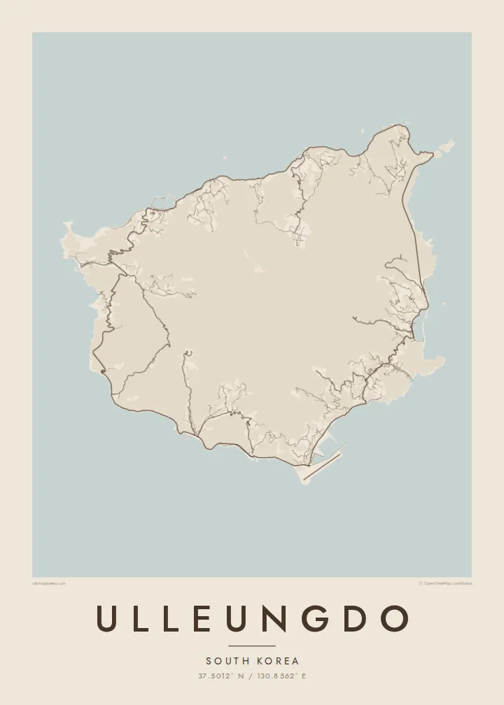
A road now circles the island close to the water, passing through tunnels and along cliffs. On the map it forms an almost complete loop just inside the shoreline.
Posta faʻafanua faigofie · South Korea
37.5012° N / 130.8562° E
A steep volcanic island rising from the East Sea, ringed by a coastal road and small harbours set in narrow valleys.


Tasi le aai, lagona e lima
Tapi se sitaili e vaai ai i luga o le puipui. E tutusa uma le tau o sitaili — pe lolomiina, faapipiiina, pe avea ma faila HD.
 Pika Moni · Faila Lolomi 24 × 36″
Manino mo le lolomi
O se vaega atoa (100%) lenei mai le faila lolomi moni. O posita uma — pe lolomiina, faapipiiina pe download mai — e faia i luga o a matou server i le 300 DPI, e oo atu i le 7,200 × 10,800 pika, ina ia manino pea auala laiti i luga o se lolomiga 24 × 36″.
I luga o le puipui


Le faʻafanua
Ulleungdo lies in the sea east of the Korean peninsula. It is the summit of an old volcano that rises steeply from deep water. From above it is nearly round, with a rugged interior that climbs to Seonginbong, its highest peak, and a coastline dominated by cliffs. Villages occupy the few places where valleys meet the sea, most of them on narrow strips of flat ground.
Dodong, the main port, is squeezed into a steep valley on the east coast. Its streets climb inland because there is no room to spread along the shore. For generations the island has been known for squid fishing, with the catch hung out to dry around the harbours. On the north side, the Nari Basin is a rare stretch of flat ground high among the peaks.
An Ulleungdo map poster is shaped by the tension between a smooth, round outline and crowded detail at its edges. The coastal road, which took decades to complete around the whole island, draws a ring just inside the shoreline, and the harbour towns appear as small, dense knots. The interior peaks are left almost entirely clear.
A road now circles the island close to the water, passing through tunnels and along cliffs. On the map it forms an almost complete loop just inside the shoreline.
The main port fills a deep, narrow valley on the east coast. Its streets run uphill rather than along the water, which gives it a compact, vertical pattern.
In the north, a flat basin inside the old volcano holds farmland and a small village. On the map it is a quiet, open patch surrounded by high ground.
Fai mo oe
Faʻaopoopo se aso, se igoa po o sau lava upu, sui le sitaili, lapoʻa po o le itu.
O le preview e leai se totogi e maualalo le resolution ma iai se watermark. O lolomi ma faila HD e faia i le 300 DPI, e oo atu i le 7,200 × 10,800 px, e aunoa ma se watermark.
Aisea Ulleungdo
Ulleungdo is a place people travel far to reach, usually by a long ferry ride, and it stays with them. A map poster records its unusual shape and what it takes to live there, which makes it a natural choice for anyone who has walked its trails or grown up in its harbours.
Put the island's name in the title and the date of your visit in the subtitle, and keep or edit the coordinates line. Choose Classic black & white, Noir, Paper, Blueprint or Sand. Each $9 download includes 300 DPI PNG and print-ready PDF files in six sizes, without a watermark.
Faatau le posita Ulleungdo| Lapoʻa lolomi | Manino | Faila |
|---|---|---|
| 30 × 40 cm (11.8 × 15.7″) | 3,543 × 4,724 px | PNG · PDF |
| 29.7 × 42 cm (A3, 11.7 × 16.5″) | 3,508 × 4,961 px | PNG · PDF |
| 42 × 59.4 cm (A2, 16.5 × 23.4″) | 4,961 × 7,016 px | PNG · PDF |
| 45.7 × 61 cm (18 × 24″) | 5,400 × 7,200 px | PNG · PDF |
| 50 × 70 cm (19.7 × 27.6″) | 5,906 × 8,268 px | PNG · PDF |
| 61 × 91.4 cm (24 × 36″) | 7,200 × 10,800 px | PNG · PDF |
Ae faʻatusatusa, o le faʻataʻitaʻiga e leai se totogi e 900 px le lautele, e iai le faʻailoga vai ma e mo mata. O faila HD e oʻo atu i le 8× le manino i itu taʻitasi ma e lolomi manino i le lapoʻa atoa o le posta.
Filifili se sitaili i le pito i luga o le itulau, ona filifili lea o le Posita Lolomi — se lapopoa ma, afai e te fiafia, se faavaa — po o Faila HD Numera. E na o le tasi laasaga o le Checkout, ma o le a fesuia'i lou itulau o oka i le taimi lava e mae'a ai le totogi.
E lolomiina i luga o pepa matte maualuga le tulaga e 200 gsm, i se tasi o lapopoa e ono, mai le 30 × 40 cm i le 24 × 36″. E amata le tau o posita lolomi mai le $39, aofia ai le auina atu.
Ioe. Filifili se faavaa laau malosi i le lanu uliuli, sina, oak masani, po o le laau pogisa. E aofia ai se tioata e le gau ma ua saunia e tautau i luga. E amata le tau o posita faavaa mai le $99, aofia ai le auina atu.
E leai se totogi mo le uta i le lalolagi atoa. O poster ta'itasi e lolomi e le paaga lolomi e latalata mai i matou i atunuu e 30+, ma e masani ona taunuu i aso faigaluega e 3–7. E mafai ona e mulimuli i le tulaga ma le tracking i le "Aʻu Oka". O nisi atunuu e 2–5 vaiaso, ma i atunuu matou te lei tuuina atu ai, e taʻu atu e le saite iā te oe ae e te leʻi totogiina.
Auina mai se ata i totonu o le 14 aso talu ona taunuu, ma o le a matou toe lolomiina e leai se totogi po o le toe faafoi atu lau tupe.
Ioe. I totonu o le editor i lenei itulau, suia le ulutala, le ulutala laititi ma le laina o coordinates i soo se mea e te fiafia i ai, ma filifili se sitaili ma le lapopoa. O oka lolomi, faavaa ma numera e faaaoga uma lava lau mamanu.
Mo le $9 e te maua ai faila PNG 300 DPI ma PDF ua saunia mo le lolomi i lapopoa uma e ono, e aunoa ma se watermark, e mafai ona lolomi i soo se mea. Le mautinoa lava? Download muamua se preview e leai se totogi ma le watermark.
Latalata ane
