The Una River
The river runs straight through the town and is its main organising line on the map, with streets and blocks lining both banks and bridges stitching the two halves together.
Posta faʻafanua faigofie · Brazil
13.3703° S / 39.0731° W
A river town on the Una estuary, its streets following both banks before mangrove channels open toward the Atlantic coast of Bahia


Tasi le aai, lagona e lima
Tapi se sitaili e vaai ai i luga o le puipui. E tutusa uma le tau o sitaili — pe lolomiina, faapipiiina, pe avea ma faila HD.
 Pika Moni · Faila Lolomi 24 × 36″
Manino mo le lolomi
O se vaega atoa (100%) lenei mai le faila lolomi moni. O posita uma — pe lolomiina, faapipiiina pe download mai — e faia i luga o a matou server i le 300 DPI, e oo atu i le 7,200 × 10,800 pika, ina ia manino pea auala laiti i luga o se lolomiga 24 × 36″.
I luga o le puipui


Le faʻafanua
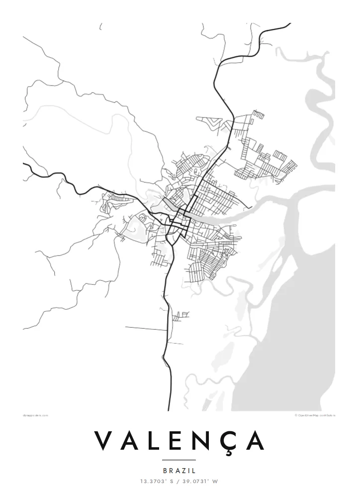
Valença sits on the Una River a short way inland from the Bahian coast, and from above the river decides everything. The town spreads along both banks, joined by bridges, with the older core close to the water and newer neighbourhoods climbing the low hills behind. Downstream, the channel widens into an estuary edged with mangroves, where solid land gives way to a loose pattern of creeks and islands.
This layout has long made Valença a place of arrival and departure. Boats leave its waterfront for the islands of the Tinharé archipelago, including Morro de São Paulo and Boipeba, and the town has a long tradition of building wooden boats by hand. In the nineteenth century it also became home to one of Brazil's early textile mills, which drew on the river for its power.
A Valença map poster turns this river geography into a clear graphic. The Una draws a strong line through the composition, the street grid gathers tightly around it, and the estuary to the east breaks into fine, irregular shapes. In black and white, the contrast between the dense town and the open water reads especially well, giving the print both structure and a sense of the coast just beyond it.
The river runs straight through the town and is its main organising line on the map, with streets and blocks lining both banks and bridges stitching the two halves together.
East of the centre, the river widens and splits into channels among mangroves, so the plain outline of the land dissolves into delicate, branching water shapes toward the sea.
The waterfront is a departure point for boats to the Tinharé archipelago, including Morro de São Paulo and Boipeba, which ties the town's plan closely to the water.
Fai mo oe
Faʻaopoopo se aso, se igoa po o sau lava upu, sui le sitaili, lapoʻa po o le itu.
O le preview e leai se totogi e maualalo le resolution ma iai se watermark. O lolomi ma faila HD e faia i le 300 DPI, e oo atu i le 7,200 × 10,800 px, e aunoa ma se watermark.
Aisea Valença
For people who grew up in Valença, or who passed through on the way to the islands, this map holds a particular route: the river, the quay, the streets leading down to the boats. It is a quiet reminder of a place defined by water and travel.
Each poster can be personalised with your own title, subtitle and coordinates line, perhaps a family name or the date of a trip. Choose from five styles, Classic black & white, Noir, Paper, Blueprint or Sand, to suit the room where it will hang.
Faatau le posita Valença| Lapoʻa lolomi | Manino | Faila |
|---|---|---|
| 30 × 40 cm (11.8 × 15.7″) | 3,543 × 4,724 px | PNG · PDF |
| 29.7 × 42 cm (A3, 11.7 × 16.5″) | 3,508 × 4,961 px | PNG · PDF |
| 42 × 59.4 cm (A2, 16.5 × 23.4″) | 4,961 × 7,016 px | PNG · PDF |
| 45.7 × 61 cm (18 × 24″) | 5,400 × 7,200 px | PNG · PDF |
| 50 × 70 cm (19.7 × 27.6″) | 5,906 × 8,268 px | PNG · PDF |
| 61 × 91.4 cm (24 × 36″) | 7,200 × 10,800 px | PNG · PDF |
Ae faʻatusatusa, o le faʻataʻitaʻiga e leai se totogi e 900 px le lautele, e iai le faʻailoga vai ma e mo mata. O faila HD e oʻo atu i le 8× le manino i itu taʻitasi ma e lolomi manino i le lapoʻa atoa o le posta.
Filifili se sitaili i le pito i luga o le itulau, ona filifili lea o le Posita Lolomi — se lapopoa ma, afai e te fiafia, se faavaa — po o Faila HD Numera. E na o le tasi laasaga o le Checkout, ma o le a fesuia'i lou itulau o oka i le taimi lava e mae'a ai le totogi.
E lolomiina i luga o pepa matte maualuga le tulaga e 200 gsm, i se tasi o lapopoa e ono, mai le 30 × 40 cm i le 24 × 36″. E amata le tau o posita lolomi mai le $39, aofia ai le auina atu.
Ioe. Filifili se faavaa laau malosi i le lanu uliuli, sina, oak masani, po o le laau pogisa. E aofia ai se tioata e le gau ma ua saunia e tautau i luga. E amata le tau o posita faavaa mai le $99, aofia ai le auina atu.
E leai se totogi mo le uta i le lalolagi atoa. O poster ta'itasi e lolomi e le paaga lolomi e latalata mai i matou i atunuu e 30+, ma e masani ona taunuu i aso faigaluega e 3–7. E mafai ona e mulimuli i le tulaga ma le tracking i le "Aʻu Oka". O nisi atunuu e 2–5 vaiaso, ma i atunuu matou te lei tuuina atu ai, e taʻu atu e le saite iā te oe ae e te leʻi totogiina.
Auina mai se ata i totonu o le 14 aso talu ona taunuu, ma o le a matou toe lolomiina e leai se totogi po o le toe faafoi atu lau tupe.
Ioe. I totonu o le editor i lenei itulau, suia le ulutala, le ulutala laititi ma le laina o coordinates i soo se mea e te fiafia i ai, ma filifili se sitaili ma le lapopoa. O oka lolomi, faavaa ma numera e faaaoga uma lava lau mamanu.
Mo le $9 e te maua ai faila PNG 300 DPI ma PDF ua saunia mo le lolomi i lapopoa uma e ono, e aunoa ma se watermark, e mafai ona lolomi i soo se mea. Le mautinoa lava? Download muamua se preview e leai se totogi ma le watermark.
