Yellow River
The river, widened here into Wuhai Lake, forms the eastern edge of the district, a broad band of open water that dominates the composition.
Posta faʻafanua faigofie · China
39.4994° N / 106.7117° E
A mining district on the west bank of the Yellow River, its streets pressed between the water and bare desert hills.



Tasi le aai, lagona e lima
Tapi se sitaili e vaai ai i luga o le puipui. E tutusa uma le tau o sitaili — pe lolomiina, faapipiiina, pe avea ma faila HD.
 Pika Moni · Faila Lolomi 24 × 36″
Manino mo le lolomi
O se vaega atoa (100%) lenei mai le faila lolomi moni. O posita uma — pe lolomiina, faapipiiina pe download mai — e faia i luga o a matou server i le 300 DPI, e oo atu i le 7,200 × 10,800 pika, ina ia manino pea auala laiti i luga o se lolomiga 24 × 36″.
I luga o le puipui


Le faʻafanua
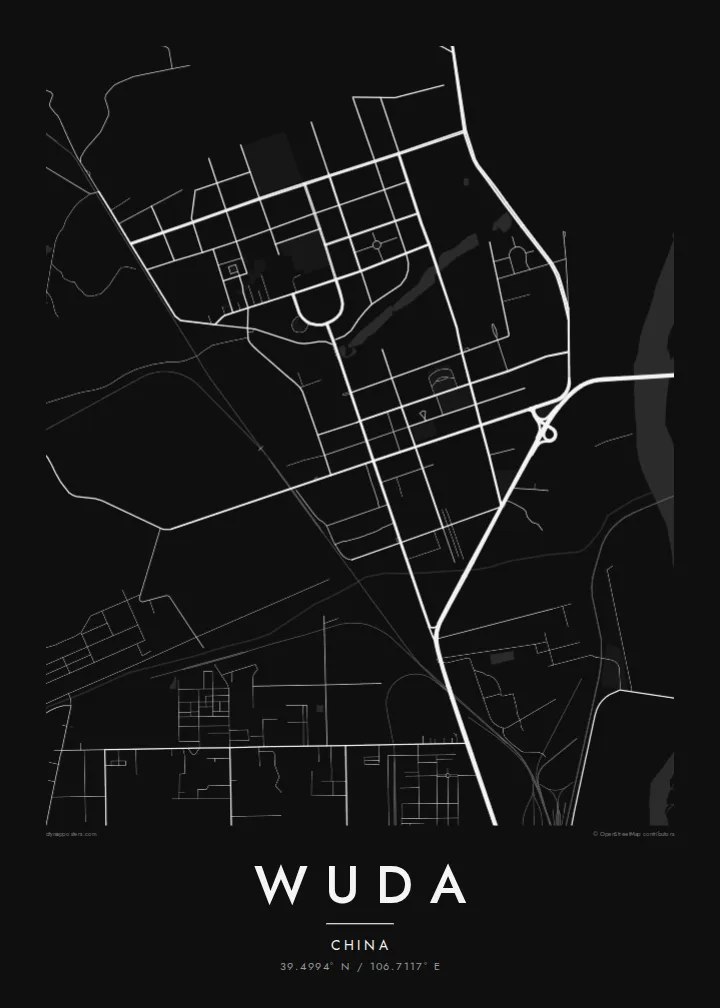
Wuda is one of the districts of Wuhai, a coal city in the west of Inner Mongolia. It lies on the western bank of the Yellow River, facing the rest of Wuhai across the water. On a map the urban area forms a strip of regular blocks between the river and the dry, bare hills rising to the west.
The streets follow a practical grid, typical of Chinese industrial towns planned in the second half of the twentieth century, with broad main roads and large residential compounds. Beyond them the map opens onto mine sites, rail lines and empty ground. A Wuda map poster shows a sharp boundary between the settled area and the arid landscape.
A dam downstream has widened the Yellow River here into a broad reservoir known as Wuhai Lake, giving the eastern edge of the district a large, smooth expanse of water. The area is also known for its long-burning underground coal fires, which scientists have studied for years as an example of an environmental problem that is hard to contain.
The river, widened here into Wuhai Lake, forms the eastern edge of the district, a broad band of open water that dominates the composition.
Wide, straight roads and rectangular blocks make up the town centre, reflecting its growth as a planned settlement serving the surrounding coal mines.
West of the town, bare hills and mining areas take over from streets, leaving sparse lines of haul roads and railways across largely empty ground.
Fai mo oe
Faʻaopoopo se aso, se igoa po o sau lava upu, sui le sitaili, lapoʻa po o le itu.
O le preview e leai se totogi e maualalo le resolution ma iai se watermark. O lolomi ma faila HD e faia i le 300 DPI, e oo atu i le 7,200 × 10,800 px, e aunoa ma se watermark.
Aisea Wuda
Wuda was shaped by hard work in an unforgiving landscape, and for families linked to its mines it carries strong memories. The map shows that setting plainly: river, town and desert in three clear bands.
Add a title, a subtitle or a meaningful date, edit the coordinates line, and select Classic black & white, Noir, Paper, Blueprint or Sand. Download six HD sizes for $9 as watermark-free PNG and PDF files, or order a matte printed poster.
Faatau le posita Wuda| Lapoʻa lolomi | Manino | Faila |
|---|---|---|
| 30 × 40 cm (11.8 × 15.7″) | 3,543 × 4,724 px | PNG · PDF |
| 29.7 × 42 cm (A3, 11.7 × 16.5″) | 3,508 × 4,961 px | PNG · PDF |
| 42 × 59.4 cm (A2, 16.5 × 23.4″) | 4,961 × 7,016 px | PNG · PDF |
| 45.7 × 61 cm (18 × 24″) | 5,400 × 7,200 px | PNG · PDF |
| 50 × 70 cm (19.7 × 27.6″) | 5,906 × 8,268 px | PNG · PDF |
| 61 × 91.4 cm (24 × 36″) | 7,200 × 10,800 px | PNG · PDF |
Ae faʻatusatusa, o le faʻataʻitaʻiga e leai se totogi e 900 px le lautele, e iai le faʻailoga vai ma e mo mata. O faila HD e oʻo atu i le 8× le manino i itu taʻitasi ma e lolomi manino i le lapoʻa atoa o le posta.
Filifili se sitaili i le pito i luga o le itulau, ona filifili lea o le Posita Lolomi — se lapopoa ma, afai e te fiafia, se faavaa — po o Faila HD Numera. E na o le tasi laasaga o le Checkout, ma o le a fesuia'i lou itulau o oka i le taimi lava e mae'a ai le totogi.
E lolomiina i luga o pepa matte maualuga le tulaga e 200 gsm, i se tasi o lapopoa e ono, mai le 30 × 40 cm i le 24 × 36″. E amata le tau o posita lolomi mai le {printFrom}, aofia ai le auina atu.
Ioe. Filifili se faavaa laau malosi i le lanu uliuli, sina, oak masani, po o le laau pogisa. E aofia ai se tioata e le gau ma ua saunia e tautau i luga. E amata le tau o posita faavaa mai le {framedFrom}, aofia ai le auina atu.
E leai se totogi mo le uta i le lalolagi atoa. O poster ta'itasi e lolomi e le paaga lolomi e latalata mai i matou i atunuu e 30+, ma e masani ona taunuu i aso faigaluega e 3–7. E mafai ona e mulimuli i le tulaga ma le tracking i le "Aʻu Oka". O nisi atunuu e 2–5 vaiaso, ma i atunuu matou te lei tuuina atu ai, e taʻu atu e le saite iā te oe ae e te leʻi totogiina.
Auina mai se ata i totonu o le 14 aso talu ona taunuu, ma o le a matou toe lolomiina e leai se totogi po o le toe faafoi atu lau tupe.
Ioe. I totonu o le editor i lenei itulau, suia le ulutala, le ulutala laititi ma le laina o coordinates i soo se mea e te fiafia i ai, ma filifili se sitaili ma le lapopoa. O oka lolomi, faavaa ma numera e faaaoga uma lava lau mamanu.
Mo le $9 e te maua ai faila PNG 300 DPI ma PDF ua saunia mo le lolomi i lapopoa uma e ono, e aunoa ma se watermark, e mafai ona lolomi i soo se mea. Le mautinoa lava? Download muamua se preview e leai se totogi ma le watermark.
Latalata ane
