Kunes River valley
The river runs west along the valley floor, spreading into several channels in places. On the poster it forms a long, flowing line that anchors the town and the fields around it.
Posta faʻafanua faigofie · China
43.4265° N / 83.2496° E
A county seat in the Kunes River valley, where a small grid gives way to farmland, grassland and Tian Shan slopes.



Tasi le aai, lagona e lima
Tapi se sitaili e vaai ai i luga o le puipui. E tutusa uma le tau o sitaili — pe lolomiina, faapipiiina, pe avea ma faila HD.
 Pika Moni · Faila Lolomi 24 × 36″
Manino mo le lolomi
O se vaega atoa (100%) lenei mai le faila lolomi moni. O posita uma — pe lolomiina, faapipiiina pe download mai — e faia i luga o a matou server i le 300 DPI, e oo atu i le 7,200 × 10,800 pika, ina ia manino pea auala laiti i luga o se lolomiga 24 × 36″.
I luga o le puipui


Le faʻafanua
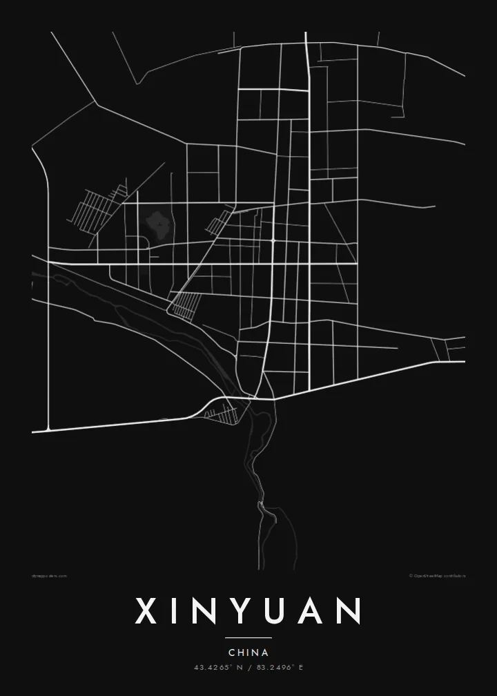
Xinyuan is a county in the Ili Kazakh Autonomous Prefecture of northern Xinjiang, set in a long valley between ranges of the Tian Shan. Its main town lies near the Kunes River, and on a map the built-up area is small and orderly, a grid of wide streets surrounded by irrigated fields, shelter belts and roads that follow the valley floor.
The county is best known for the Nalati grasslands, high pastures on the slopes further up the valley that have long been used by Kazakh herders and now draw many summer visitors. Mountain streams feed the valley from both sides, so the landscape around the town is patterned with channels, fields and scattered villages.
A Xinyuan map poster emphasises the setting as much as the streets. The town grid is compact enough to sit comfortably in the centre of the frame, while the river's shifting channels and the rising terrain around it give the composition movement. It is a map of a mountain valley that happens to have a town in it.
The river runs west along the valley floor, spreading into several channels in places. On the poster it forms a long, flowing line that anchors the town and the fields around it.
Xinyuan's centre is laid out in regular blocks with broad streets, a pattern common to county towns in the region. It gives the map a neat, readable core amid open country.
Further up the valley to the east, high pastures rise toward the mountains. In a wider framing they appear as open ground crossed by a few roads and streams, underlining how much space surrounds the town.
Fai mo oe
Faʻaopoopo se aso, se igoa po o sau lava upu, sui le sitaili, lapoʻa po o le itu.
O le preview e leai se totogi e maualalo le resolution ma iai se watermark. O lolomi ma faila HD e faia i le 300 DPI, e oo atu i le 7,200 × 10,800 px, e aunoa ma se watermark.
Aisea Xinyuan
Xinyuan appeals to people who have travelled the Ili valley, herded or farmed there, or grown up in the town before moving to Ürümqi or further away. The map captures both the order of the streets and the openness of the valley, which is what most people remember.
You can change the title, subtitle and coordinates line to name a village, a route or a summer spent on the grasslands. Five styles are available, from Noir to Sand, and the files come as 300 DPI PNG and print-ready PDF in six sizes for $9, with no watermark.
Faatau le posita Xinyuan| Lapoʻa lolomi | Manino | Faila |
|---|---|---|
| 30 × 40 cm11.8 × 15.7″ | 3,543 × 4,724 px | PNG · PDF |
| 29.7 × 42 cm (A3)11.7 × 16.5″ | 3,508 × 4,961 px | PNG · PDF |
| 42 × 59.4 cm (A2)16.5 × 23.4″ | 4,961 × 7,016 px | PNG · PDF |
| 45.7 × 61 cm18 × 24″ | 5,400 × 7,200 px | PNG · PDF |
| 50 × 70 cm19.7 × 27.6″ | 5,906 × 8,268 px | PNG · PDF |
| 61 × 91.4 cm24 × 36″ | 7,200 × 10,800 px | PNG · PDF |
Ae faʻatusatusa, o le faʻataʻitaʻiga e leai se totogi e 900 px le lautele, e iai le faʻailoga vai ma e mo mata. O faila HD e oʻo atu i le 8× le manino i itu taʻitasi ma e lolomi manino i le lapoʻa atoa o le posta.
Filifili se sitaili i le pito i luga o le itulau, ona filifili lea o le Posita Lolomi — se lapopoa ma, afai e te fiafia, se faavaa — po o Faila HD Numera. E na o le tasi laasaga o le Checkout, ma o le a fesuia'i lou itulau o oka i le taimi lava e mae'a ai le totogi.
E lolomiina i luga o pepa matte maualuga le tulaga e 200 gsm, i se tasi o lapopoa e ono, mai le 30 × 40 cm i le 24 × 36″. E amata le tau o posita lolomi mai le $39, aofia ai le auina atu.
Ioe. Filifili se faavaa laau malosi i le lanu uliuli, sina, oak masani, po o le laau pogisa. E aofia ai se tioata e le gau ma ua saunia e tautau i luga. E amata le tau o posita faavaa mai le $99, aofia ai le auina atu.
E leai se totogi o le auina atu i atunuu e 60+. O pepa ata taʻitasi e lolomiina e le tasi o matou paaga lolomi e latalata mai i atunuu e 30+, ma e masani ona taunuu i le 3–7 aso faigaluega. E mafai ona e mulimulitaia le tulaga ma le sailiga i lalo o My Orders. O nisi atunuu e 2–5 vaiaso, ma i nofoaga e lei matou auina atu iai, e taʻu atu e le saite ia te oe a o lei totogi.
Auina mai se ata i totonu o le 14 aso talu ona taunuu, ma o le a matou toe lolomiina e leai se totogi po o le toe faafoi atu lau tupe.
Ioe. I totonu o le editor i lenei itulau, suia le ulutala, le ulutala laititi ma le laina o coordinates i soo se mea e te fiafia i ai, ma filifili se sitaili ma le lapopoa. O oka lolomi, faavaa ma numera e faaaoga uma lava lau mamanu.
Mo le $9 e te maua ai faila PNG 300 DPI ma PDF ua saunia mo le lolomi i lapopoa uma e ono, e aunoa ma se watermark, e mafai ona lolomi i soo se mea. Le mautinoa lava? Download muamua se preview e leai se totogi ma le watermark.
Latalata ane
