Senegal River
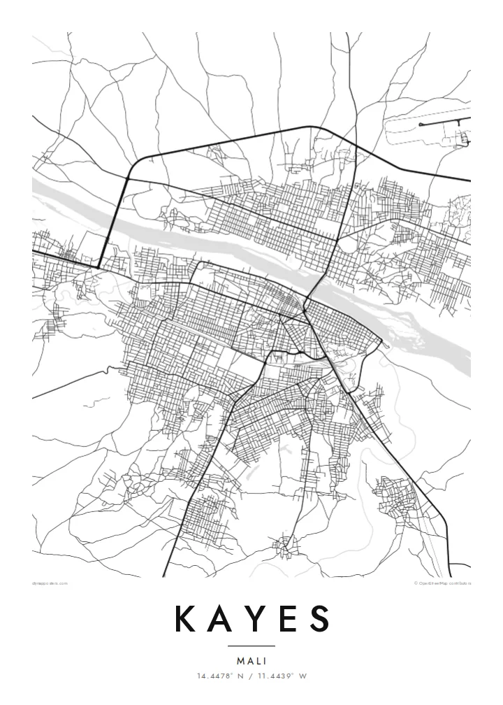
The river runs along the northern side of the town, a broad curved line on the map that once made Kayes a key inland port for river trade.
Bango la ramani la kisasa · Mali
14.4478° N / 11.4439° W
A Sahel river town on the Senegal River, with the old railway line and hot, open plains around it


Mji mmoja, hisia tano
Gusa mtindo ili kuuona ukutani. Mitindo yote yana bei sawa — iliyochapishwa, yenye fremu au kama faili za HD.
 Pikseli halisi · faili la kuchapisha 24 × 36″
Makali ya kuchapisha
Hii ni sehemu ya 100% ya faili halisi la kuchapisha. Kila bango — likiwa limechapishwa, lenye fremu au lililopakuliwa — huundwa kwenye seva zetu kwa 300 DPI, hadi pikseli 7,200 × 10,800, ili hata njia ndogo kabisa zibaki wazi kwenye uchapishaji wa 24 × 36″.
Ukutani


Ramani
Kayes lies on the Senegal River in western Mali, close to the borders with Senegal and Mauritania. On a map the river is the town's defining line, curving along its northern edge, while streets spread southward across flat, open ground. Low, rocky hills and dry plains frame the town, giving it a stark setting typical of the western Sahel.
Kayes was the capital of the French colony of Upper Senegal and Niger until the administration moved to Bamako in the early twentieth century. It grew as a river port and as a station on the Dakar–Niger railway, and it is known as one of the hottest towns in Africa. The old fort of Médine stands upriver.
A Kayes map poster places the Senegal River across the composition, with the town's grid of streets set against it and the railway cutting a straight line through. In black and white, the open spaces around the town speak to the dry plains, while the river gives the map its strongest curve.
The river runs along the northern side of the town, a broad curved line on the map that once made Kayes a key inland port for river trade.
The Dakar–Niger railway passes through Kayes, and its straight line across the town is a reminder of the route that shaped its growth.
Beyond the built-up area, sparse roads and wide empty spaces reflect the dry, open plains and low hills that surround the town.
Ifanye iwe yako
Ongeza tarehe, jina au maneno yako mwenyewe, badilisha mtindo, saizi au mkao.
Onyesho la bure lina ubora wa chini na alama ya maji. Machapisho na faili za HD huundwa kwa 300 DPI, hadi px 7,200 × 10,800, bila alama ya maji.
Kwa nini Kayes
For the many people from Kayes living elsewhere, in Bamako, Dakar or abroad, a map of the town by the river is a strong reminder of home. The river and railway give the design clear, memorable lines.
Personalise the title, subtitle and coordinates, and choose from Classic black & white, Noir, Paper, Blueprint and Sand. The $9 digital package covers six sizes with no watermark, and printed posters ship from partners in over 30 countries.
Agiza bango la Kayes| Saizi ya kuchapisha | Ubora | Faili |
|---|---|---|
| 30 × 40 cm11.8 × 15.7″ | 3,543 × 4,724 px | PNG · PDF |
| 29.7 × 42 cm (A3)11.7 × 16.5″ | 3,508 × 4,961 px | PNG · PDF |
| 42 × 59.4 cm (A2)16.5 × 23.4″ | 4,961 × 7,016 px | PNG · PDF |
| 45.7 × 61 cm18 × 24″ | 5,400 × 7,200 px | PNG · PDF |
| 50 × 70 cm19.7 × 27.6″ | 5,906 × 8,268 px | PNG · PDF |
| 61 × 91.4 cm24 × 36″ | 7,200 × 10,800 px | PNG · PDF |
Kwa kulinganisha, hakikisho la bure lina upana wa px 900, lina alama ya maji na limekusudiwa kwa skrini. Faili za HD zina ubora hadi mara 8 zaidi kila upande na huchapishwa vizuri kwa saizi kamili ya bango.
Chagua mtindo juu ya ukurasa, kisha chagua Bango Lililochapishwa — ukubwa na, ukipenda, fremu — au Faili za Kidijitali za HD. Malipo huchukua hatua moja tu, na ukurasa wa agizo lako husasishwa mara malipo yanapokamilika.
Huchapishwa kwenye karatasi bora ya matte ya 200 gsm katika mojawapo ya ukubwa sita, kutoka 30 × 40 cm hadi 24 × 36″. Mabango yaliyochapishwa huanzia $39, ikijumuisha usafirishaji.
Ndiyo. Chagua fremu ya mbao thabiti katika rangi nyeusi, nyeupe, mwaloni wa asili au mbao nyeusi. Inakuja na kioo kisichovunjika na iko tayari kuning'inizwa. Mabango yenye fremu huanzia $99, ikijumuisha usafirishaji.
Usafirishaji ni bila malipo kwa nchi 60+. Kila bango huchapishwa na mshirika wetu wa uchapishaji aliye karibu zaidi nawe, kati ya nchi 30+, na kwa kawaida hufika ndani ya siku 3–7 za kazi. Unaweza kufuatilia hali na ufuatiliaji wa kifurushi katika Oda Zangu. Nchi chache huchukua wiki 2–5, na pale ambapo bado hatusafirishi, tovuti hukueleza kabla ya kulipa.
Tutumie picha ndani ya siku 14 baada ya kufika na tutalichapisha upya bila malipo au kukurejeshea pesa.
Ndiyo. Kwenye kihariri cha ukurasa huu, badilisha kichwa, kichwa kidogo na mstari wa kuratibu kuwa chochote unachopenda, kisha chagua mtindo na ukubwa. Maagizo yaliyochapishwa, yenye fremu na ya kidijitali yote hutumia muundo wako hasa.
Kwa $9 unapata faili za PNG za 300 DPI na PDF tayari kuchapishwa katika ukubwa wote sita, bila alama ya maji, ili uchapishe popote. Bado huna uhakika? Pakua kwanza onyesho la bure lenye alama ya maji.
Karibu
