Prairie grid
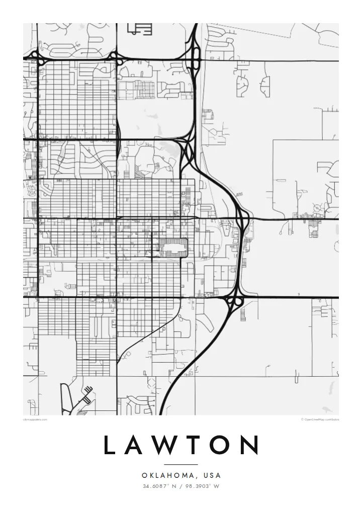
Numbered streets and avenues run north–south and east–west across flat land. They form one of the clearest and most regular urban grids in the southern Plains.
Bango la ramani la kisasa · Marekani
34.6087° N / 98.3903° W
A southwest Oklahoma city laid out on a prairie grid, beside Fort Sill and the rising Wichita Mountains.


Mji mmoja, hisia tano
Gusa mtindo ili kuuona ukutani. Mitindo yote yana bei sawa — iliyochapishwa, yenye fremu au kama faili za HD.
 Pikseli halisi · faili la kuchapisha 24 × 36″
Makali ya kuchapisha
Hii ni sehemu ya 100% ya faili halisi la kuchapisha. Kila bango — likiwa limechapishwa, lenye fremu au lililopakuliwa — huundwa kwenye seva zetu kwa 300 DPI, hadi pikseli 7,200 × 10,800, ili hata njia ndogo kabisa zibaki wazi kwenye uchapishaji wa 24 × 36″.
Ukutani


Ramani
Lawton was founded in 1901, when land from the former Kiowa, Comanche and Apache reservation was opened to settlement by lottery. The town was surveyed quickly on open prairie, and its map still reflects that origin. A clear grid of numbered streets and avenues, aligned to the compass, stretches out from the original town site.
Fort Sill, a large U.S. Army post established in 1869, lies directly north of the city and covers a large area on the map with its own roads, ranges and buildings. To the northwest the Wichita Mountains rise from the plains, home to a national wildlife refuge. Lakes and creeks add curved lines to the otherwise straight pattern.
A Lawton map poster sets a disciplined city grid against wide, open military land and the edge of the mountains. The contrast between the dense, regular streets and the sparse areas beyond gives the composition a strong structure. It is a meaningful piece for Army families who passed through Fort Sill and for people who grew up in the city itself.
Numbered streets and avenues run north–south and east–west across flat land. They form one of the clearest and most regular urban grids in the southern Plains.
The historic Army post occupies a large area north of the city. On the map it appears as a quieter zone with its own internal roads and wide open training ground.
To the northwest, the granite hills of the Wichita Mountains rise from the prairie. They add rugged, irregular ground and lakes at the edge of a wider composition.
Ifanye iwe yako
Ongeza tarehe, jina au maneno yako mwenyewe, badilisha mtindo, saizi au mkao.
Onyesho la bure lina ubora wa chini na alama ya maji. Machapisho na faili za HD huundwa kwa 300 DPI, hadi px 7,200 × 10,800, bila alama ya maji.
Kwa nini Lawton
Lawton means a great deal to the many service members stationed at Fort Sill over the years, as well as to families with deep Comanche County roots. A map poster marks a posting, a hometown or a first house in a plain, lasting way.
Personalise the title, subtitle and coordinates line, perhaps with the years of a posting. Choose Classic black & white, Noir, Paper, Blueprint or Sand. Download HD files for $9, or order a matte printed poster with an optional wooden frame.
Agiza bango la Lawton| Saizi ya kuchapisha | Ubora | Faili |
|---|---|---|
| 30 × 40 cm11.8 × 15.7″ | 3,543 × 4,724 px | PNG · PDF |
| 29.7 × 42 cm (A3)11.7 × 16.5″ | 3,508 × 4,961 px | PNG · PDF |
| 42 × 59.4 cm (A2)16.5 × 23.4″ | 4,961 × 7,016 px | PNG · PDF |
| 45.7 × 61 cm18 × 24″ | 5,400 × 7,200 px | PNG · PDF |
| 50 × 70 cm19.7 × 27.6″ | 5,906 × 8,268 px | PNG · PDF |
| 61 × 91.4 cm24 × 36″ | 7,200 × 10,800 px | PNG · PDF |
Kwa kulinganisha, hakikisho la bure lina upana wa px 900, lina alama ya maji na limekusudiwa kwa skrini. Faili za HD zina ubora hadi mara 8 zaidi kila upande na huchapishwa vizuri kwa saizi kamili ya bango.
Chagua mtindo juu ya ukurasa, kisha chagua Bango Lililochapishwa — ukubwa na, ukipenda, fremu — au Faili za Kidijitali za HD. Malipo huchukua hatua moja tu, na ukurasa wa agizo lako husasishwa mara malipo yanapokamilika.
Huchapishwa kwenye karatasi bora ya matte ya 200 gsm katika mojawapo ya ukubwa sita, kutoka 30 × 40 cm hadi 24 × 36″. Mabango yaliyochapishwa huanzia $39, ikijumuisha usafirishaji.
Ndiyo. Chagua fremu ya mbao thabiti katika rangi nyeusi, nyeupe, mwaloni wa asili au mbao nyeusi. Inakuja na kioo kisichovunjika na iko tayari kuning'inizwa. Mabango yenye fremu huanzia $99, ikijumuisha usafirishaji.
Usafirishaji ni bila malipo kwa nchi 60+. Kila bango huchapishwa na mshirika wetu wa uchapishaji aliye karibu zaidi nawe, kati ya nchi 30+, na kwa kawaida hufika ndani ya siku 3–7 za kazi. Unaweza kufuatilia hali na ufuatiliaji wa kifurushi katika Oda Zangu. Nchi chache huchukua wiki 2–5, na pale ambapo bado hatusafirishi, tovuti hukueleza kabla ya kulipa.
Tutumie picha ndani ya siku 14 baada ya kufika na tutalichapisha upya bila malipo au kukurejeshea pesa.
Ndiyo. Kwenye kihariri cha ukurasa huu, badilisha kichwa, kichwa kidogo na mstari wa kuratibu kuwa chochote unachopenda, kisha chagua mtindo na ukubwa. Maagizo yaliyochapishwa, yenye fremu na ya kidijitali yote hutumia muundo wako hasa.
Kwa $9 unapata faili za PNG za 300 DPI na PDF tayari kuchapishwa katika ukubwa wote sita, bila alama ya maji, ili uchapishe popote. Bado huna uhakika? Pakua kwanza onyesho la bure lenye alama ya maji.
