Heian-era grid
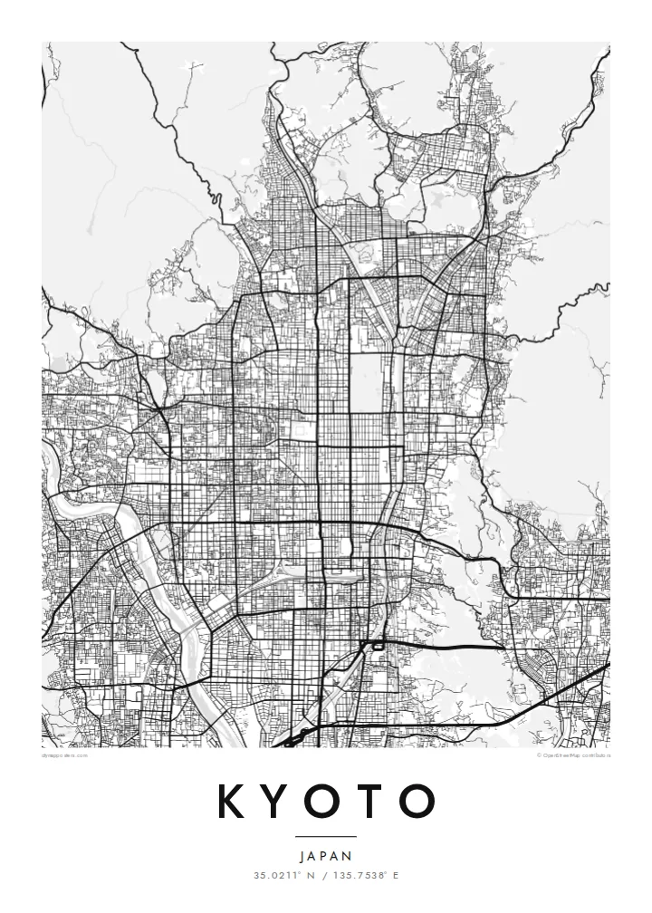
The regular grid of streets in central Kyoto dates back to the city's founding. It is laid out along a north–south axis and reads with rare clarity from above.
Póster mapa minimalista · Japan
35.0211° N / 135.7538° E
An ancient grid laid across a valley floor, bounded by wooded mountains and traced by the Kamo River


Sidade ida, estilu lima
Hili estilu ida atu haree oinsá nia sai iha didin. Estilu hotu-hotu iha folin hanesan — imprime, kaixa moldura ka arkivu HD.
 Pixel loloos · arkivu imprime 24 × 36″
Moos atu imprime
Ida ne'e mak crop 100% husi arkivu imprime loloos. Poster ida-idak — imprime, kaixa moldura ka download — ami halo iha ami-nia servidor ho 300 DPI, to'o 7,200 × 10,800 pixel, atu dalan ki'ik liu mós sai klaru iha imprime 24 × 36″.
Iha Parede


Mapa
Kyoto was founded in 794 as Heian-kyō and served as the imperial capital for more than a thousand years. Its plan was modelled on the Chinese capital Chang'an. That grid survives in the numbered east–west streets and long north–south avenues of the centre. Mountains close in on the north, east and west, and the city opens to the plain in the south.
The Kamo River runs down the eastern side of the centre, lined with walking paths. To the west the Katsura River flows past Arashiyama. The mountain edges are thick with temples and shrines. Higashiyama rises in the east, Fushimi Inari stands to the southeast, and the Kyoto Imperial Palace grounds form a large green rectangle within the grid.
A Kyoto map poster shows how strongly the city was planned and how the landscape holds it in place. The straight streets end where the mountains begin, and the rivers draw long lines down the valley. The balance between order and nature is visible in black and white. It makes one of the most elegant city maps in Asia.
The regular grid of streets in central Kyoto dates back to the city's founding. It is laid out along a north–south axis and reads with rare clarity from above.
The river runs straight south along the east side of downtown and is crossed by a series of bridges. Its long line is the spine of the eastern city.
The palace park forms a large open rectangle in the grid north of downtown. It is a quiet space that anchors the centre of the composition.
Halo ita-nia póster rasik
Aumenta data, naran ka liafuan rasik, troka estilu, tamañu ka orientasaun.
Preview grátis nian rezolusaun ki'ik no iha marka bee. Imprime no arkivu HD ami halo ho 300 DPI, to'o 7,200 × 10,800 px, laiha marka bee.
Tanba sa Kyoto
Kyoto is a city people remember in detail: a temple visit, a season, a stretch of the river path. Its map works as a keepsake of a journey and as a refined design object in its own right.
The poster can carry your own title, a subtitle with a date or phrase, and a coordinates line. Choose from Classic black & white, Noir, Paper, Blueprint or Sand to suit the room.
Enkomenda poster Kyoto| Tamañu imprime | Rezolusaun | Arkivu |
|---|---|---|
| 30 × 40 cm11.8 × 15.7″ | 3,543 × 4,724 px | PNG · PDF |
| 29.7 × 42 cm (A3)11.7 × 16.5″ | 3,508 × 4,961 px | PNG · PDF |
| 42 × 59.4 cm (A2)16.5 × 23.4″ | 4,961 × 7,016 px | PNG · PDF |
| 45.7 × 61 cm18 × 24″ | 5,400 × 7,200 px | PNG · PDF |
| 50 × 70 cm19.7 × 27.6″ | 5,906 × 8,268 px | PNG · PDF |
| 61 × 91.4 cm24 × 36″ | 7,200 × 10,800 px | PNG · PDF |
Atu kompara, previzaun gratuita luan 900 px, iha marka d'água no ba ekrã de'it. Arkivu HD iha rezolusaun to'o dala 8 boot liu iha direksaun ida-idak no imprime moos iha tamañu póster kompletu.
Hili estilu ida iha leten pájina, depois hili Poster Imprime — hili tamañu ida no, se hakarak, moldura ida — ka Arkivu Digital HD. Pagamentu halo iha pasu ida deit, no pájina enkomenda sei update kedas hafoin pagamentu remata.
Ami imprime iha papel matte kualidade aas 200 gsm, iha tamañu neen, husi 30 × 40 cm to'o 24 × 36″. Poster imprime hahú husi $39, haruka livre.
Bele. Hili moldura kayu solidu kór metan, mutin, oak natural ka kayu nakukun. Mai ho vidru la-kilat no prontu atu kandu iha didin. Poster ho moldura hahú husi $99, haruka livre.
Entrega gratuita ba país 60+. Poster ida-idak ami-nia parseiru impresaun besik liu mak imprime iha país 30+ no normalmente to'o iha loron-servisu 3–7. Ita bele haree estatutu no rastreiu iha Ha'u-nia Enkomenda. Países balu presiza semana 2–5, no iha fatin ne'ebé ami seidauk entrega, site sei hatete ba ita molok selu.
Haruka foto ba ami iha loron 14 hafoin simu, no ami sei imprime fali ho grátis ka selu fila fali osan.
Bele. Iha editor iha pájina ne'e, troka titulu, subtitulu no liña koordenadas ba buat ne'ebé ita hakarak, depois hili estilu no tamañu. Enkomenda imprime, moldura ka digital hotu-hotu uza sasán ita-nia desain loloos.
Ho $9 ita simu arkivu PNG 300 DPI no PDF prontu-imprime iha tamañu neen hotu, laiha marka bee, atu imprime iha fatin ida-ida. Seidauk lai serteza? Download uluk preview grátis ho marka bee.
