Channel shoreline
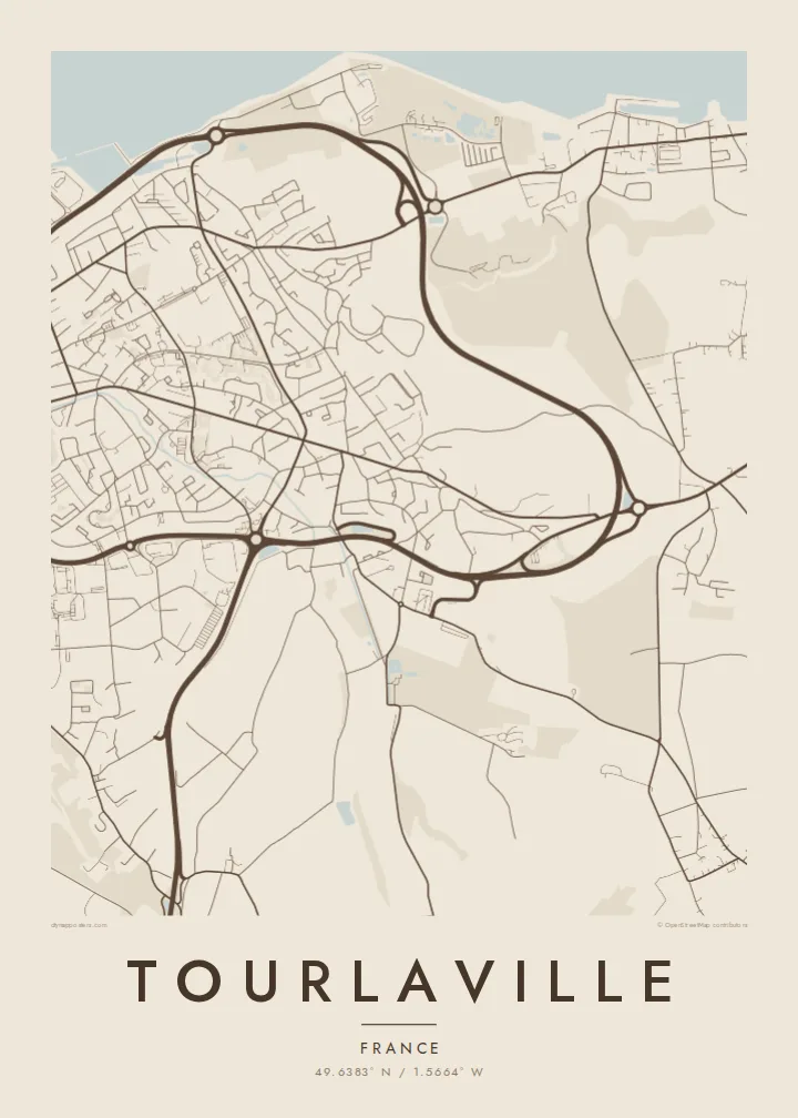
The northern edge of the map follows the Channel coast. Its long sweeping line frames the town and sets the composition's upper boundary.
Póster mapa minimalista · France
49.6383° N / 1.5664° W
The eastern side of Cherbourg on the Cotentin coast, stretching from the Channel shore up into wooded valleys


Sidade ida, estilu lima
Hili estilu ida atu haree oinsá nia sai iha didin. Estilu hotu-hotu iha folin hanesan — imprime, kaixa moldura ka arkivu HD.
 Pixel loloos · arkivu imprime 24 × 36″
Moos atu imprime
Ida ne'e mak crop 100% husi arkivu imprime loloos. Poster ida-idak — imprime, kaixa moldura ka download — ami halo iha ami-nia servidor ho 300 DPI, to'o 7,200 × 10,800 pixel, atu dalan ki'ik liu mós sai klaru iha imprime 24 × 36″.
Iha Parede


Mapa
Tourlaville lies on the northern coast of the Cotentin peninsula in Normandy, immediately east of Cherbourg. In 2016 it merged with Cherbourg and neighbouring communes to form Cherbourg-en-Cotentin, but it retains a distinct identity and appears clearly on the map as its own area.
The commune stretches from the English Channel shoreline inland towards hills and valleys. Its best-known landmark is the Château des Ravalet, a Renaissance castle set in a park in the valley south of the town. From above, the streets become less dense as they move away from the coast into greener, more open land.
A Tourlaville map poster brings together the sea, the edge of a port city and the Normandy countryside. The print places the coastline across the top of the frame, with streets thinning out towards the valleys and the château grounds to the south.
The northern edge of the map follows the Channel coast. Its long sweeping line frames the town and sets the composition's upper boundary.
The Renaissance castle and its park sit in the valley south of the town. They appear as an open green area with formal paths among the wooded land.
To the west, Tourlaville's streets merge into Cherbourg. The poster shows where one district blends into the next.
Halo ita-nia póster rasik
Aumenta data, naran ka liafuan rasik, troka estilu, tamañu ka orientasaun.
Preview grátis nian rezolusaun ki'ik no iha marka bee. Imprime no arkivu HD ami halo ho 300 DPI, to'o 7,200 × 10,800 px, laiha marka bee.
Tanba sa Tourlaville
Tourlaville suits people who know the Cotentin: families, sailors, and those who have walked along the coast or visited the Ravalet gardens. A map captures that quiet corner of Normandy.
You can change the title, subtitle and coordinates line, choosing whether to use Tourlaville or Cherbourg-en-Cotentin. Then select one of five styles: Classic black and white, Noir, Paper, Blueprint or Sand.
Enkomenda poster Tourlaville| Tamañu imprime | Rezolusaun | Arkivu |
|---|---|---|
| 30 × 40 cm11.8 × 15.7″ | 3,543 × 4,724 px | PNG · PDF |
| 29.7 × 42 cm (A3)11.7 × 16.5″ | 3,508 × 4,961 px | PNG · PDF |
| 42 × 59.4 cm (A2)16.5 × 23.4″ | 4,961 × 7,016 px | PNG · PDF |
| 45.7 × 61 cm18 × 24″ | 5,400 × 7,200 px | PNG · PDF |
| 50 × 70 cm19.7 × 27.6″ | 5,906 × 8,268 px | PNG · PDF |
| 61 × 91.4 cm24 × 36″ | 7,200 × 10,800 px | PNG · PDF |
Atu kompara, previzaun gratuita luan 900 px, iha marka d'água no ba ekrã de'it. Arkivu HD iha rezolusaun to'o dala 8 boot liu iha direksaun ida-idak no imprime moos iha tamañu póster kompletu.
Hili estilu ida iha leten pájina, depois hili Poster Imprime — hili tamañu ida no, se hakarak, moldura ida — ka Arkivu Digital HD. Pagamentu halo iha pasu ida deit, no pájina enkomenda sei update kedas hafoin pagamentu remata.
Ami imprime iha papel matte kualidade aas 200 gsm, iha tamañu neen, husi 30 × 40 cm to'o 24 × 36″. Poster imprime hahú husi $39, haruka livre.
Bele. Hili moldura kayu solidu kór metan, mutin, oak natural ka kayu nakukun. Mai ho vidru la-kilat no prontu atu kandu iha didin. Poster ho moldura hahú husi $99, haruka livre.
Entrega gratuita ba país 60+. Poster ida-idak ami-nia parseiru impresaun besik liu mak imprime iha país 30+ no normalmente to'o iha loron-servisu 3–7. Ita bele haree estatutu no rastreiu iha Ha'u-nia Enkomenda. Países balu presiza semana 2–5, no iha fatin ne'ebé ami seidauk entrega, site sei hatete ba ita molok selu.
Haruka foto ba ami iha loron 14 hafoin simu, no ami sei imprime fali ho grátis ka selu fila fali osan.
Bele. Iha editor iha pájina ne'e, troka titulu, subtitulu no liña koordenadas ba buat ne'ebé ita hakarak, depois hili estilu no tamañu. Enkomenda imprime, moldura ka digital hotu-hotu uza sasán ita-nia desain loloos.
Ho $9 ita simu arkivu PNG 300 DPI no PDF prontu-imprime iha tamañu neen hotu, laiha marka bee, atu imprime iha fatin ida-ida. Seidauk lai serteza? Download uluk preview grátis ho marka bee.
