Uraniborg site
Near the middle of the island, the site of Tycho Brahe's observatory and its reconstructed garden forms a small, deliberate geometric figure among the surrounding farmland.
Minimalistik karta plakaty · Şwesiýa
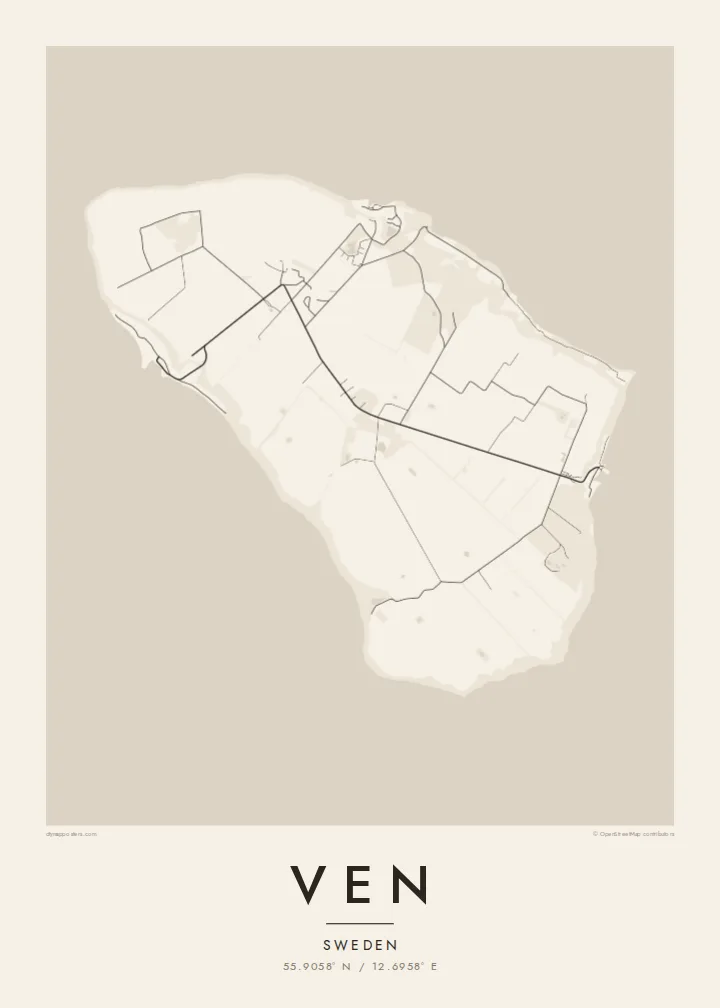
55.9058° N / 12.6958° E
A small, flat-topped island in the Øresund, ringed by steep banks and crossed by quiet lanes between open fields.




Bir şäher, bäş keýp
Diwarda nähili görünjegini görmek üçin stile basyň. Ähli stiller bir bahadan — çap edilen, çarçuwaly ýa-da HD faýl görnüşinde.
 Hakyky pikseller · 24 × 36″ çap faýly
Çapda aýdyň
Bu hakyky çap faýlynyň 100% kesigi. Her poster — çap edilen, çarçuwaly ýa-da ýüklenen — serwerlerimizde 300 DPI, 7,200 × 10,800 piksele çenli işlenip taýýarlanýar, şonuň üçin iň kiçi köçeler hem 24 × 36″ çapda arassa görünýär.
Diwarda


Karta
Ven sits in the middle of the Øresund, the strait between Sweden and Denmark, and belongs to Landskrona municipality on the Swedish side. It is a compact oval island, a raised plateau of farmland whose steep slopes and cliffs drop to narrow beaches. From above, the patchwork of fields and the thin lanes crossing them give the interior a gentle, almost ruled texture.
The island is best known for Tycho Brahe, the Danish astronomer who was granted Ven in the 1570s and built two observatories there, Uraniborg and the partly underground Stjerneborg. His precise observations of the stars and planets later helped Johannes Kepler work out the laws of planetary motion. The site is now a museum, and its Renaissance garden has been reconstructed in a clear geometric plan.
The harbours of Bäckviken and Kyrkbacken sit on the east and west coasts respectively, and the lanes between them are mostly travelled by bicycle. A Ven map poster shows the whole island at a glance. A little of the Swedish or Danish shore at the edge hints at how close the island is to both countries, and how separate from them.
Near the middle of the island, the site of Tycho Brahe's observatory and its reconstructed garden forms a small, deliberate geometric figure among the surrounding farmland.
The plateau ends abruptly at steep grassy slopes that drop to the water, so the coastline on the map is a firm, clean edge rather than a ragged one.
The ferry from Landskrona arrives at this small east-coast harbour. From there a short road climbs off the water onto the plateau and fans out into the island's lanes.
Özüňiziňki ediň
Sene, at ýa-da öz setiriňizi goşuň, stili, ölçegi ýa-da ugry üýtgediň.
Mugt deslapky görnüş pes durulykda we suw belgili. Çaplar we HD faýllar suw belgisiz, 300 DPI, 7,200 × 10,800 px çenli işlenip taýýarlanýar.
Näme üçin Ven
Ven suits anyone drawn to the history of astronomy, and the many people who have cycled its lanes on a summer day out from Landskrona or Copenhagen. Its tidy oval shape is easy to recognise and holds a surprising amount of history for so small a place.
Personalise the title, subtitle and coordinates line, perhaps with the date of that ride or a line about Tycho, and choose one of five styles. Noir makes a fitting night sky. The files come as 300 DPI PNG and print-ready PDF in six sizes for $9, or you can order a printed poster, framed if you like.
Ven posterini sargyt ediň| Çap ölçegi | Çözgüt | Faýllar |
|---|---|---|
| 30 × 40 cm (11.8 × 15.7″) | 3,543 × 4,724 px | PNG · PDF |
| 29.7 × 42 cm (A3, 11.7 × 16.5″) | 3,508 × 4,961 px | PNG · PDF |
| 42 × 59.4 cm (A2, 16.5 × 23.4″) | 4,961 × 7,016 px | PNG · PDF |
| 45.7 × 61 cm (18 × 24″) | 5,400 × 7,200 px | PNG · PDF |
| 50 × 70 cm (19.7 × 27.6″) | 5,906 × 8,268 px | PNG · PDF |
| 61 × 91.4 cm (24 × 36″) | 7,200 × 10,800 px | PNG · PDF |
Deňeşdirmek üçin: mugt nusga 900 px giňlikde, suw belgili we ekranlar üçin niýetlenen. HD faýllaryň çözgüdi her tarapa 8 esse çenli ýokary we doly plakat ölçeginde arassa çap edilýär.
Sahypanyň ýokarsyndan stili saýlaň, soňra Çap edilen Poster — ölçegini we isleseňiz çarçuwasyny — ýa-da Sanly HD Faýllary saýlaň. Töleg bir ädimde amala aşyrylýar, tölegiňiz geçen dessine sargyt sahypaňyz täzelenýär.
Ol ýokary hilli 200 gsm mat kagyza, alty ölçegiň birinde, 30 × 40 sm-den 24 × 36″-a çenli çap edilýär. Çap edilen posterler {printFrom}-dan başlaýar, eltip bermek bahasy girýär.
Hawa. Gara, ak, tebigy dub ýa-da garaňky agaç reňkinde tutuş agaç çarçuwany saýlaň. Ol döwülmeýän aýna bilen gelýär we asmaga taýýar. Çarçuwaly posterler {framedFrom}-dan başlaýar, eltip bermek bahasy girýär.
Eltip bermek dünýäniň ähli ýerinde mugt. Her poster 30-dan gowrak ýurtdaky çap hyzmatdaşlarymyzyň iň ýakynynda çap edilýär we adatça 3–7 iş gününde gelýär. Ýagdaýyny we yzarlamany Sargytlarym bölüminde görüp bilersiňiz.
Eltilenden soň 14 günüň dowamynda bize surat iberiň, biz ony mugt gaýtadan çap ederis ýa-da puluňyzy yzyna gaýtararys.
Hawa. Bu sahypadaky redaktorda ady, kiçi ady we koordinatlar setirini islän zadyňyza üýtgediň, soňra stil we ölçeg saýlaň. Çap edilen, çarçuwaly we sanly sargytlaryň ählisi siziň dizaýnyňyzy takyk ulanýar.
$9 üçin ähli alty ölçegde, suw belgisiz, islendik ýerde çap edip bolýan 300 DPI PNG we çap etmäge taýyn PDF faýllaryny alýarsyňyz. Entek gutarnykly karara gelmediňizmi? Ilki mugt, suw belgili deslapky görnüşi göçürip alyň.
