Boyne Viaduct
Opened in 1855, the railway viaduct spans the Boyne east of the centre, its long straight line crossing the river and the quays below it in a single stroke on the map.
سادہ نقشہ پوسٹر · آئرلینڈ
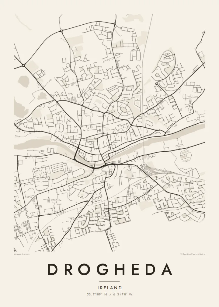
53.7189° N / 6.3478° W
An old port town on both banks of the Boyne, crossed by a tall railway viaduct near the river's mouth.




ایک شہر، پانچ انداز
کوئی بھی اسٹائل منتخب کریں اور دیکھیں دیوار پر کیسا لگتا ہے۔ ہر اسٹائل کی قیمت ایک جیسی ہے — پرنٹ، فریم یا HD فائلز کے طور پر۔
 اصل پکسلز · 24 × 36″ پرنٹ فائل
پرنٹ جیسی واضح
یہ اصل پرنٹ فائل کا 100% کراپ ہے۔ ہر پوسٹر — چاہے پرنٹ ہو، فریم شدہ ہو یا ڈاؤن لوڈ کیا گیا ہو — ہمارے سرورز پر 300 DPI اور 7,200 × 10,800 پکسلز تک رینڈر کیا جاتا ہے، تاکہ 24 × 36″ پرنٹ پر بھی سب سے باریک گلیاں تک صاف نظر آئیں۔
دیوار پر


نقشہ
Drogheda stands on the River Boyne a few kilometres upstream from its mouth on the Irish Sea, and the town has grown on both banks, straddling the boundary between counties Louth and Meath. From above, the river cuts a clear line through the centre, with the medieval street pattern gathered along the north bank and the land rising on the south side toward Millmount.
Millmount, a prominent mound topped by a Martello tower, overlooks the town, and parts of the medieval walls survive, most notably St Laurence's Gate, a tall barbican on the eastern side of the old centre. The town was besieged by Oliver Cromwell in 1649, and St Peter's Church holds the preserved head of St Oliver Plunkett.
East of the centre, the Boyne Viaduct carries the Dublin–Belfast railway high above the river, one of the most striking structures on the Irish rail network. Upriver lie Brú na Bóinne and the site of the Battle of the Boyne. A Drogheda map poster frames the river, the viaduct and the old town in a single composition.
Opened in 1855, the railway viaduct spans the Boyne east of the centre, its long straight line crossing the river and the quays below it in a single stroke on the map.
North of the river, the old town keeps a compact pattern of narrow streets and lanes, with St Laurence's Gate marking the line of the former walls.
On the south bank, the mound of Millmount rises above the town with its Martello tower, the high point from which the whole river crossing can be seen.
اسے اپنا بنائیں
کوئی تاریخ، نام یا اپنی کوئی سطر شامل کریں، انداز، سائز یا رخ بدلیں۔
مفت پیش منظر کم ریزولیوشن اور واٹر مارک کے ساتھ ہوتا ہے۔ پرنٹس اور HD فائلز 300 DPI اور 7,200 × 10,800 px تک بغیر واٹر مارک کے رینڈر کی جاتی ہیں۔
Drogheda ہی کیوں
Drogheda is a hometown for many who have moved to Dublin or further afield, and a gateway to the Boyne Valley for visitors. A map of its river, viaduct and old streets is a clear, understated way to keep the town close.
Add a family name or a date to the title and subtitle, adjust the coordinates line, and choose from five styles, including Noir and Blueprint. HD files cost $9 in six sizes, and printed posters ship from partners in more than 30 countries.
Drogheda پوسٹر آرڈر کریں| پرنٹ سائز | ریزولوشن | فائلیں |
|---|---|---|
| 30 × 40 cm (11.8 × 15.7″) | 3,543 × 4,724 px | PNG · PDF |
| 29.7 × 42 cm (A3, 11.7 × 16.5″) | 3,508 × 4,961 px | PNG · PDF |
| 42 × 59.4 cm (A2, 16.5 × 23.4″) | 4,961 × 7,016 px | PNG · PDF |
| 45.7 × 61 cm (18 × 24″) | 5,400 × 7,200 px | PNG · PDF |
| 50 × 70 cm (19.7 × 27.6″) | 5,906 × 8,268 px | PNG · PDF |
| 61 × 91.4 cm (24 × 36″) | 7,200 × 10,800 px | PNG · PDF |
موازنے کے لیے، مفت پیش نظارہ 900 px چوڑا ہے، واٹر مارک کے ساتھ اور اسکرین کے لیے ہے۔ HD فائلوں کی ریزولوشن ہر سمت میں 8 گنا تک زیادہ ہے اور پورے پوسٹر سائز پر صاف پرنٹ ہوتی ہیں۔
صفحے کے اوپر ایک اسٹائل منتخب کریں، پھر پرنٹڈ پوسٹر چنیں — سائز اور چاہیں تو فریم بھی — یا ڈیجیٹل HD فائلز۔ چیک آؤٹ صرف ایک مرحلے میں مکمل ہوتا ہے، اور ادائیگی مکمل ہوتے ہی آپ کا آرڈر پیج اپڈیٹ ہو جاتا ہے۔
یہ پریمیم 200 gsm میٹ پیپر پر چھ سائزز میں سے کسی ایک میں پرنٹ ہوتا ہے، 30 × 40 cm سے لے کر 24 × 36″ تک۔ پرنٹڈ پوسٹرز کی قیمت $39 سے شروع ہوتی ہے، شپنگ شامل ہے۔
جی ہاں۔ سیاہ، سفید، قدرتی اوک یا گہری لکڑی میں سولڈ ووڈ فریم منتخب کریں۔ اس کے ساتھ ٹوٹ پھوٹ سے محفوظ شیشہ لگا ہوتا ہے اور یہ لٹکانے کے لیے تیار ہوتا ہے۔ فریم شدہ پوسٹرز کی قیمت $99 سے شروع ہوتی ہے، شپنگ شامل ہے۔
دنیا بھر میں شپنگ مفت ہے۔ ہر پوسٹر 30 سے زائد ممالک میں ہمارے قریب ترین پرنٹ پارٹنر کے ہاں چھپتا ہے اور عموماً 3–7 کاروباری دنوں میں پہنچ جاتا ہے۔ آرڈر کی صورتحال اور ٹریکنگ آپ میرے آرڈرز میں دیکھ سکتے ہیں۔ چند ممالک میں 2–5 ہفتے لگتے ہیں، اور جہاں ہم ابھی شپنگ نہیں کرتے وہاں ادائیگی سے پہلے سائٹ خود آپ کو بتا دیتی ہے۔
ڈیلیوری کے 14 دنوں کے اندر ہمیں تصویر بھیجیں اور ہم اسے مفت دوبارہ پرنٹ کر دیں گے یا آپ کی رقم واپس کر دیں گے۔
جی ہاں۔ اس صفحے کے ایڈیٹر میں عنوان، ذیلی عنوان اور کوآرڈینیٹس کی لائن کو اپنی مرضی کے مطابق تبدیل کریں، اور اسٹائل و سائز منتخب کریں۔ پرنٹڈ، فریم شدہ اور ڈیجیٹل — سب آرڈرز میں عین آپ کا ڈیزائن استعمال ہوتا ہے۔
$9 میں آپ کو 300 DPI PNG اور پرنٹ کے لیے تیار PDF فائلز چھ سائزز میں ملتی ہیں، بغیر واٹر مارک کے، جنہیں کہیں بھی پرنٹ کیا جا سکتا ہے۔ ابھی یقین نہیں؟ پہلے مفت واٹر مارک والا پیش منظر ڈاؤن لوڈ کریں۔
