Valley floor
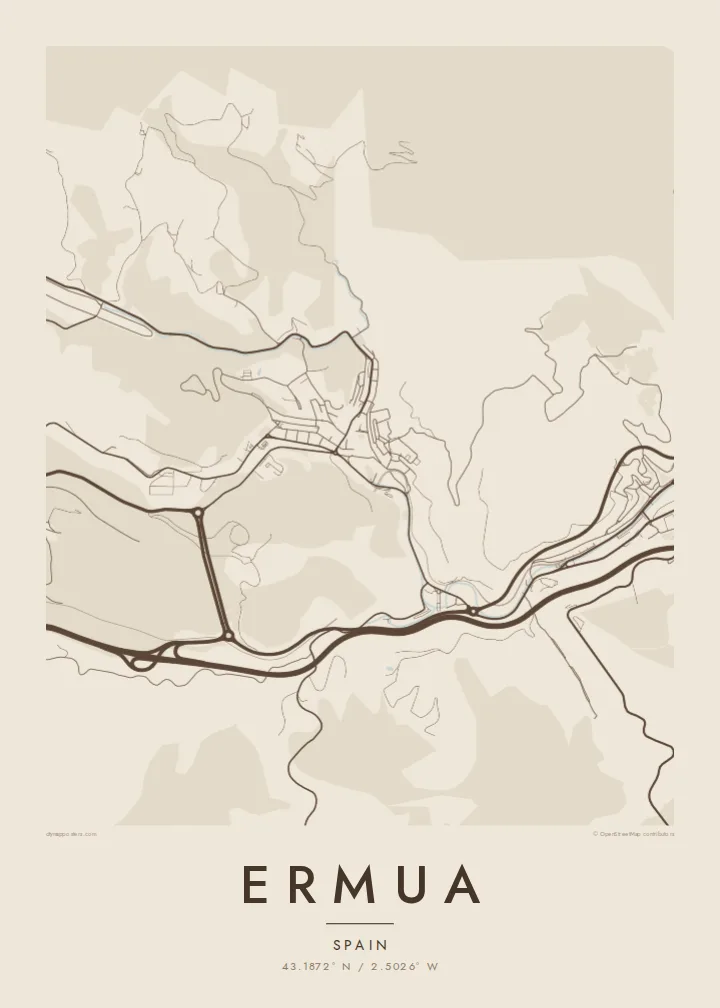
The flattest land runs along the valley bottom, where the main road, the watercourse and industrial plots share a narrow strip. On the map it forms the spine from which the rest of the town branches.
Ata mapa faigafua · Spain
43.1872° N / 2.5026° W
A compact Basque valley town, its dense blocks packed along a narrow floor and climbing steep green slopes toward the ridges.


Kolo e tahi, lanu e nima
Tuki he sitaili ke sio ai ʻi te holo. ʻE tatau pē te totogi ʻo te sitaili fuli pē — mokā tā, fakakātoa, peʻe ko he ʻu faila HD.
 Ngaahi pikiseli moʻoni · faila tā 24 × 36″
Mahino lelei ki te pulūti
Ko he konga 100% ʻo te faila tā moʻoni ʻaeni. Ko te ʻu posita fuli pē — mokā tā, fakakātoa peʻe download — ʻe fakatupu ʻi ʻomātou seva ʻi te 300 DPI, aʻu ki te 7,200 × 10,800 pikiseli, koia ʻe nofo mahino ai te ʻu ala liliki ʻi he tā 24 × 36″.
ʻI Te Puipui


Te mapa
Ermua sits in a tight valley in the Basque Country, at the eastern edge of Bizkaia where it meets Gipuzkoa. From above, the town reads as a concentrated knot of streets squeezed between hillsides, with building footprints crowding the flat ground and then stepping upward wherever the slope allows. Open wooded and pastoral terrain presses in from almost every side, so the edge of the built area is sharp and easy to trace.
Much of that density comes from the second half of the twentieth century, when metalworking and industry drew workers from across Spain and apartment blocks rose quickly on limited land. On a map this shows as tall, closely set rows following the contours, a small historic core near the centre, and industrial parcels along the valley bottom. To the east the streets run almost without a break into neighbouring Eibar, blurring a provincial border.
A Ermua map poster captures a place defined by topography as much as by planning: the road winding through the valley, the curving streets that bend to fit the hills, and the thin corridors of green between built-up pockets. Rendered in simple black lines on white, the town becomes a study in how a community fits itself into steep ground, with every street shaped by the land around it.
The flattest land runs along the valley bottom, where the main road, the watercourse and industrial plots share a narrow strip. On the map it forms the spine from which the rest of the town branches.
Residential streets curl around the slopes rather than cutting straight across them, producing looping, terraced patterns that give Ermua a distinctive, almost layered texture when seen from above.
To the east the urban fabric continues into Eibar across the Bizkaia–Gipuzkoa boundary, so the poster frame shows one continuous valley settlement rather than two clearly separate towns.
Faʻu ke ʻau ʻa ʻau
Tuku he ʻaho, he hingoa peʻe he kiʻi palalau ʻa ʻau, fetogi te faʻahiga, te lahi peʻe te hake.
Ko te faʻata fua noa ʻe māʻulalo hono lelei pea ʻe ʻi ai he fakaʻilonga. Ko te ʻu tā mo te ʻu faila HD ʻe fakatupu ʻi te 300 DPI, aʻu ki te 7,200 × 10,800 px, ʻe mole ʻi ai he fakaʻilonga.
Koteā ko Ermua
For people who grew up here or whose families arrived to work in the valley's industry, Ermua is closely tied to home and to shared memory. A map of its streets is a quiet, personal way to keep that place close, whether it hangs in a flat nearby or somewhere far away.
You can set your own title, subtitle and coordinates line, adding a family name or a meaningful date, and choose from five styles: Classic black & white, Noir, Paper, Blueprint or Sand. Download HD files for $9 or order a matte print, with a wooden frame if you like.
Fakatau te posita Ermua| Lahi ʻo te pulūti | Mahino | Faile |
|---|---|---|
| 30 × 40 cm (11.8 × 15.7″) | 3,543 × 4,724 px | PNG · PDF |
| 29.7 × 42 cm (A3, 11.7 × 16.5″) | 3,508 × 4,961 px | PNG · PDF |
| 42 × 59.4 cm (A2, 16.5 × 23.4″) | 4,961 × 7,016 px | PNG · PDF |
| 45.7 × 61 cm (18 × 24″) | 5,400 × 7,200 px | PNG · PDF |
| 50 × 70 cm (19.7 × 27.6″) | 5,906 × 8,268 px | PNG · PDF |
| 61 × 91.4 cm (24 × 36″) | 7,200 × 10,800 px | PNG · PDF |
Ko te ata ʻe mole totogi ʻe 900 px tona laulahi, mo te fakaʻilonga, ki te sioʻata pē. Ko te ʻu faile HD ʻe aʻu ki te liuga 8 tona mahino, pea ʻe pulūti lelei ʻi te lahi kātoa.
Fili he sitaili ʻi te tuʻa ʻo te pasina, pea fili leva te Posita Tā — he lahi pea, kapau ʻe ke loto ai, he fakakātoa — peʻe ko te ʻu Faila HD Fakakomipiuta. ʻE tahi pē te sitepu ʻo te totogi, pea ʻe fakafou fakavavevave pē tau pasina fakatau mai te taimi ʻe fai ai te totogi.
ʻE tā ʻi he pepa lelei ʻaupito 200 gsm matte, ʻi he tahi ʻo te ono lahi, mai te 30 × 40 cm ki te 24 × 36″. ʻE kamata te ʻu posita tā ʻi te $39, kātoa mo te ʻave.
ʻIo. Fili he fakakātoa ʻakau moʻoni ʻi te kili, hinahina, ʻakau natula peʻe ʻakau ʻuliʻuli. ʻE ʻi ai mo he sioga mālohi ʻe mole mafesi, pea kua teu ke tautau. ʻE kamata te ʻu posita fakakātoa ʻi te $99, kātoa mo te ʻave.
Ko te ʻave ʻe tuʻa totogi ʻi te malamanei katoa. Ko te pōsita ʻe tā e te kaumeʻa tā ʻoku ofi taha ʻi fenua e 30+, pea ʻe aʻu mai ʻi ʻaho gāue e 3–7. ʻE lava ke ke sivi te tuʻunga mo te tulitaki ʻi lalo ʻo Aku ʻōta. ʻE ʻi ai ni fenua ʻe uike e 2–5, pea ʻi te ʻu fenua ʻe mole te ʻave ki ai, ʻe fakahā e te sitē ʻi muʻa ʻo te totogi.
Fekau mai he ʻata ʻi loto ʻi te ʻaho e 14 talu mai te aʻu mai, pea mātou toe tā noa peʻe toe totogi atu.
ʻIo. ʻI te meʻa fakatonutonu ʻi te pasina ʻaeni, fetogi te kupu tāfito, te kupu lalo pea mo te laina koʻoliteti ki he meʻa fuli pē ʻe ke loto ai, pea fili he sitaili mo he lahi. Ko te ʻu fakatau tā, fakakātoa mo fakakomipiuta ʻe fakaʻaogaʻi katoa pē tou fakatātā.
Mo te $9 ʻe ke maʻu ai te ʻu faila PNG 300 DPI mo PDF kua teu ke tā, ʻi te ono lahi kātoa, ʻe mole ʻi ai he fakaʻilonga, ke ke tā ai ʻi soʻo he potu. Kei tā fakafiafia? Download muʻa he faʻata mokā mo he fakaʻilonga, ʻe fua noa.
