The Dniester curve
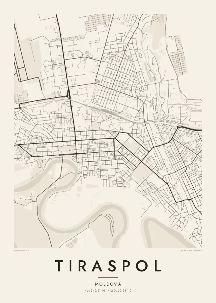
The river runs past the city's western and southern sides in a wide, gentle arc. It sets a natural border to the street pattern and gives the composition a strong, flowing line.
Ata mapa faigafua · Moldova
46.8428° N / 29.6284° E
A regular street grid on the east bank of the Dniester, with one long avenue running parallel to the river's broad curve




Kolo e tahi, lanu e nima
Tuki he sitaili ke sio ai ʻi te holo. ʻE tatau pē te totogi ʻo te sitaili fuli pē — mokā tā, fakakātoa, peʻe ko he ʻu faila HD.
 Ngaahi pikiseli moʻoni · faila tā 24 × 36″
Mahino lelei ki te pulūti
Ko he konga 100% ʻo te faila tā moʻoni ʻaeni. Ko te ʻu posita fuli pē — mokā tā, fakakātoa peʻe download — ʻe fakatupu ʻi ʻomātou seva ʻi te 300 DPI, aʻu ki te 7,200 × 10,800 pikiseli, koia ʻe nofo mahino ai te ʻu ala liliki ʻi he tā 24 × 36″.
ʻI Te Puipui


Te mapa
Tiraspol sits on the left bank of the Dniester in Transnistria, the breakaway region of Moldova. From above, the city looks orderly. A near-rectangular grid of streets spreads back from the river, and the long main avenue, 25 October Street, crosses the centre. The Dniester bends along the western and southern edges, so the water frames the town on one side and open farmland wraps the other.
The town began as a fortress in 1792, built on Alexander Suvorov's orders when the Russian Empire's border reached the Dniester. That start as a planned settlement still shows in the layout. Blocks follow straight lines instead of old winding lanes, and the wide boulevards cross at right angles. On the edges of the city the grid gives way to rail lines, industrial yards and bands of greenery along the riverbank.
A Tiraspol map poster turns that clear geometry into a quiet graphic. The dense grid in the centre, the thinner streets towards the outskirts and the smooth line of the Dniester give the print a balanced shape. Bender lies just across the water, joined by a bridge, and it sits within the same frame. The two towns read as neighbours facing each other over the river.
The river runs past the city's western and southern sides in a wide, gentle arc. It sets a natural border to the street pattern and gives the composition a strong, flowing line.
Straight streets and rectangular blocks cover the centre, laid out after the town's founding as a fortress. On a monochrome print the result is an even, rhythmic texture.
The town of Bender stands on the opposite bank, linked to Tiraspol by a road bridge. With both included, the map reads as a pair of settlements facing each other over the river.
Faʻu ke ʻau ʻa ʻau
Tuku he ʻaho, he hingoa peʻe he kiʻi palalau ʻa ʻau, fetogi te faʻahiga, te lahi peʻe te hake.
Ko te faʻata fua noa ʻe māʻulalo hono lelei pea ʻe ʻi ai he fakaʻilonga. Ko te ʻu tā mo te ʻu faila HD ʻe fakatupu ʻi te 300 DPI, aʻu ki te 7,200 × 10,800 px, ʻe mole ʻi ai he fakaʻilonga.
Koteā ko Tiraspol
Some people frame Tiraspol because they grew up there, studied there, or have family on the left bank of the Dniester. Others are drawn to the plain design of a planned city beside a river. Either way, the map holds a personal place in a calm, understated form that suits a hallway, a study or a living room.
You can change the title, the subtitle and the coordinates line to add a family name, a meaningful date or a short phrase. You can pick one of five styles: Classic black & white, Noir, Paper, Blueprint or Sand. Buy it as a $9 set of HD digital files, or order a matte print with an optional wooden frame.
Fakatau te posita Tiraspol| Lahi ʻo te pulūti | Mahino | Faile |
|---|---|---|
| 30 × 40 cm11.8 × 15.7″ | 3,543 × 4,724 px | PNG · PDF |
| 29.7 × 42 cm (A3)11.7 × 16.5″ | 3,508 × 4,961 px | PNG · PDF |
| 42 × 59.4 cm (A2)16.5 × 23.4″ | 4,961 × 7,016 px | PNG · PDF |
| 45.7 × 61 cm18 × 24″ | 5,400 × 7,200 px | PNG · PDF |
| 50 × 70 cm19.7 × 27.6″ | 5,906 × 8,268 px | PNG · PDF |
| 61 × 91.4 cm24 × 36″ | 7,200 × 10,800 px | PNG · PDF |
Ko te ata ʻe mole totogi ʻe 900 px tona laulahi, mo te fakaʻilonga, ki te sioʻata pē. Ko te ʻu faile HD ʻe aʻu ki te liuga 8 tona mahino, pea ʻe pulūti lelei ʻi te lahi kātoa.
Fili he sitaili ʻi te tuʻa ʻo te pasina, pea fili leva te Posita Tā — he lahi pea, kapau ʻe ke loto ai, he fakakātoa — peʻe ko te ʻu Faila HD Fakakomipiuta. ʻE tahi pē te sitepu ʻo te totogi, pea ʻe fakafou fakavavevave pē tau pasina fakatau mai te taimi ʻe fai ai te totogi.
ʻE tā ʻi he pepa lelei ʻaupito 200 gsm matte, ʻi he tahi ʻo te ono lahi, mai te 30 × 40 cm ki te 24 × 36″. ʻE kamata te ʻu posita tā ʻi te $39, kātoa mo te ʻave.
ʻIo. Fili he fakakātoa ʻakau moʻoni ʻi te kili, hinahina, ʻakau natula peʻe ʻakau ʻuliʻuli. ʻE ʻi ai mo he sioga mālohi ʻe mole mafesi, pea kua teu ke tautau. ʻE kamata te ʻu posita fakakātoa ʻi te $99, kātoa mo te ʻave.
Ko te fakahoko e mole totogi ki te ʼu fenua e 60+. Ko te pōsita taki taha ʼe tā e te tahi ʼo ʼemau ʼu kaufakalogo tā ʼe ofi mai, ʼi te ʼu fenua e 30+, pea ʼe hoko mai ʼi te ʼu ʼaho gaue e 3–7. ʼE feala hau ke ke vakaʼi te tuʼunga mo te tracking ʼi Oku Fakamaʼu. ʼE ʼi ai te ʼu fenua ʼe 2–5 te ʼu vaiaho, pea ʼi te ʼu fenua ʼaē ʼe heʼeki tou fakahoko ki ai, ʼe fakahā e te saite ʼi muʼa ʼo tau totogi.
Fekau mai he ʻata ʻi loto ʻi te ʻaho e 14 talu mai te aʻu mai, pea mātou toe tā noa peʻe toe totogi atu.
ʻIo. ʻI te meʻa fakatonutonu ʻi te pasina ʻaeni, fetogi te kupu tāfito, te kupu lalo pea mo te laina koʻoliteti ki he meʻa fuli pē ʻe ke loto ai, pea fili he sitaili mo he lahi. Ko te ʻu fakatau tā, fakakātoa mo fakakomipiuta ʻe fakaʻaogaʻi katoa pē tou fakatātā.
Mo te $9 ʻe ke maʻu ai te ʻu faila PNG 300 DPI mo PDF kua teu ke tā, ʻi te ono lahi kātoa, ʻe mole ʻi ai he fakaʻilonga, ke ke tā ai ʻi soʻo he potu. Kei tā fakafiafia? Download muʻa he faʻata mokā mo he fakaʻilonga, ʻe fua noa.
