Table Mountain
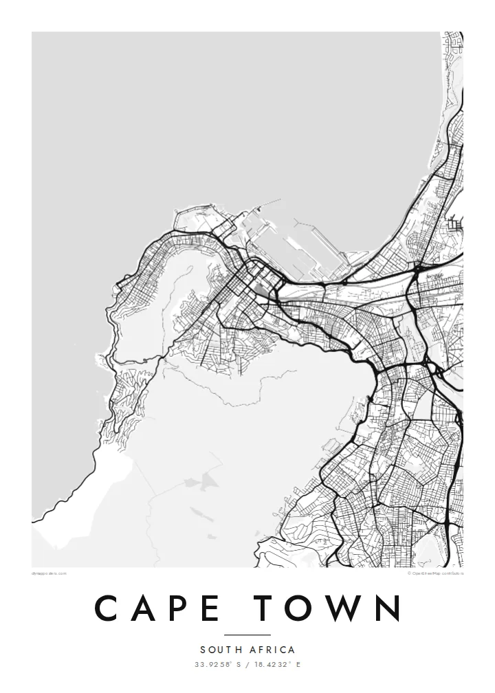
The mountain appears as a wide unbuilt shape at the heart of the map, with the grid of the City Bowl pressed up against its lower slopes.
Qeeqabak kaartah poster · South Africa
33.9258° S / 18.4232° E
A city wrapped around the foot of Table Mountain, with the Atlantic on one side and Table Bay curving to the north.


Inki magaala, konoy gaba
Qande inkih tibbixeeh derre baguley table. Kulli qande missoowa caagid—daabbisimta, dirbaabu-le kaadu HD fayla akah.
 Cagalah pixels · 24 × 36″ daabbi fayla
Maxxaacah qeeqa
Tama usuk cagalah daabbi faylak 100% qambaala. Kulli poster — daabbisimta, dirbaabu-le kaadu download geytimta — ni-server-ittal 300 DPI-l ederimta, 7,200 × 10,800 pixels fanah, tokkel iyyi ellee catoy 24 × 36″ daabbi baxsi bahisak raaqu.
Gidarih


Kaarta
Cape Town's map is defined as much by what is not built as by what is. Table Mountain and its neighbours, Devil's Peak, Lion's Head and Signal Hill, form a large empty centre around which the city arranges itself. The City Bowl sits in the amphitheatre between them, its streets sloping down toward the harbour and Table Bay.
From there the city spreads in several directions. The Atlantic Seaboard follows a narrow strip of coast west and south of the mountain, while the southern suburbs run along its eastern flank. To the east the broad, sandy Cape Flats open up, with long straight roads laid out across terrain that is almost perfectly level.
Founded in 1652 as a supply station for the Dutch East India Company, the city still keeps the five-pointed Castle of Good Hope near its centre. A Cape Town map poster makes the relationship between mountain and sea unusually clear, since the streets stop wherever the slopes become too steep.
The mountain appears as a wide unbuilt shape at the heart of the map, with the grid of the City Bowl pressed up against its lower slopes.
The harbour basins and breakwaters on Table Bay give the northern edge of the city a sharp, geometric outline of quays and docks.
The seventeenth-century pentagonal fort, with its angled bastions, is one of the most recognisable small shapes in the centre, sitting back from what was once the shoreline.
Kok tanim ab
Ayro, migaq hinnay kok tan xagar osis; gaba, ballaqa hinnay xiqa soorris.
Free preview qansarissi kee watermark-le. Daabbisimtaan kee HD fayla 300 DPI-l, 7,200 × 10,800 px fanah, watermark maleh ederimta.
Macah Cape Town
Cape Town is a place people fall for quickly and remember in detail: a walk up Lion's Head, an apartment in Sea Point, a first view of the bay. A map that shows the mountain as a quiet space at the centre carries that memory without needing a photograph.
Personalise the title and subtitle, add a date or coordinates, and choose from five styles. Blueprint suits the harbour and coastline well, while Classic black & white keeps the mountain outline crisp. Download HD files for $9 or order a printed poster with an optional frame.
Cape Town poster orme| Maxxaacah ballaqa | Qeeqa | Faylal |
|---|---|---|
| 30 × 40 cm11.8 × 15.7″ | 3,543 × 4,724 px | PNG · PDF |
| 29.7 × 42 cm (A3)11.7 × 16.5″ | 3,508 × 4,961 px | PNG · PDF |
| 42 × 59.4 cm (A2)16.5 × 23.4″ | 4,961 × 7,016 px | PNG · PDF |
| 45.7 × 61 cm18 × 24″ | 5,400 × 7,200 px | PNG · PDF |
| 50 × 70 cm19.7 × 27.6″ | 5,906 × 8,268 px | PNG · PDF |
| 61 × 91.4 cm24 × 36″ | 7,200 × 10,800 px | PNG · PDF |
Tabbaltah, limo-wayta xaqqa-le ablo 900 px ballaqa le, asta le, iskiriinih keh tan. HD faylal gexsoh inkih addal 8× fanah qeeqa le, poster ballaqa inkih addal meqeh maxxaacimta.
Baxxaqqa qari le qandiy dooriy, tohuk lakal Daabbisimtah Poster — kutuk kee, faxximek, dirbaabu — hinnay HD Digital Fayla dooru. Checkout inki wagitti geytima, kaadu ku-orme page keenih adissa akke waqdi caagoy kummite.
Usuk 200 gsm-le catam kutuk warqatal, lica katiy caagitte $39-ik hane ayta 30 × 40 cm-ik 24 × 36″ fanah, xaagu keenil warreeh.
Ee. Sarrah-le dirbaabu doori — bad, gudduc, oak-le hinnay bad-madabuy. Usuk finqisiimam ellee sange qarab-le kaadu qari umukku iyya keenih taagu. Dirbaabu-le poster $99-ik hane, xaagu keenil warreeh.
Dirsa 60+ baaxoh bilsa. Poster kasa 30+ baaxoh nel print kaadu yan kee dirgeh kaxxa kee tanah printa, kee 3–7 xaqu ayyaamah yaaxigeeh. Xaaloo kee tracking "Ac Order" gexsitam. Kaadu baaxo 2–5 isbuuc yaaxigeeh, nanu dirsi yanin baaxoh sajiitah site ku kalah tekkeh.
Geytimeek 14 ayróy addal foto naah rubbaay, cisab-le daabbisiynah hinnay ku-lacay gacisnaah.
Ee. Tama page-l edito addal, migaaq, subtitle kee coordinates sarrah faxxem fanah badal, kaadu qande kee katiy doori. Daabbisimtah, dirbaabu-le kaadu digital orme inkih ku-design cagalah yekkelen.
$9 bacisak 300 DPI PNG kee daabbisimtah adissime PDF fayla lica katiy inkih, watermark maleh, ayyi meki daabbisimtah geeytitta. Cisab makkoysemty ana? Awqak, watermark-le free preview download-eh.
