Arabian Sea coastline
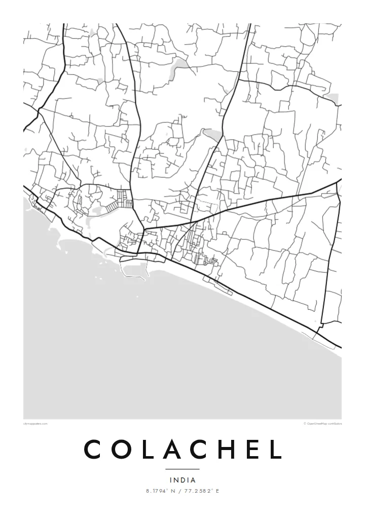
The shore is the poster's defining edge. The town's streets end abruptly against this long curve of coast, which gives the composition a strong sense of place.
Qeeqabak kaartah poster · India
8.1794° N / 77.2582° E
A fishing town on the Kanyakumari coast, where lanes run down to the Arabian Sea and boats line the shore.


Inki magaala, konoy gaba
Qande inkih tibbixeeh derre baguley table. Kulli qande missoowa caagid—daabbisimta, dirbaabu-le kaadu HD fayla akah.
 Cagalah pixels · 24 × 36″ daabbi fayla
Maxxaacah qeeqa
Tama usuk cagalah daabbi faylak 100% qambaala. Kulli poster — daabbisimta, dirbaabu-le kaadu download geytimta — ni-server-ittal 300 DPI-l ederimta, 7,200 × 10,800 pixels fanah, tokkel iyyi ellee catoy 24 × 36″ daabbi baxsi bahisak raaqu.
Gidarih


Kaarta
Colachel is a coastal town in the Kanyakumari district of Tamil Nadu, close to the southern tip of India. The most striking thing on its map is the shoreline, a long, gently curving edge where the land meets the Arabian Sea. The town's streets press close behind it, and lanes run down toward the beach and the harbour.
Fishing shapes the town, and this coast has long supported fishing communities whose settlements follow the shore. Inland the pattern loosens into roads lined with houses, coconut groves and fields, typical of this green corner of the state. The contrast between the dense seafront and the softer interior gives the drawing depth.
Colachel has a notable place in history. In the Battle of Colachel in 1741, the forces of the Travancore kingdom defeated the Dutch East India Company, and a memorial pillar marks the event. A Colachel map poster links that story to the actual coastline where it happened, drawn in clean, simple lines.
The shore is the poster's defining edge. The town's streets end abruptly against this long curve of coast, which gives the composition a strong sense of place.
Narrow lanes run at right angles to the beach and connect homes and the harbour to the water. They form a fine, comb-like pattern along the coast.
A victory pillar commemorates the 1741 battle in which Travancore defeated the Dutch. It is a small but meaningful point on the map, close to the coast.
Kok tanim ab
Ayro, migaq hinnay kok tan xagar osis; gaba, ballaqa hinnay xiqa soorris.
Free preview qansarissi kee watermark-le. Daabbisimtaan kee HD fayla 300 DPI-l, 7,200 × 10,800 px fanah, watermark maleh ederimta.
Macah Colachel
For families from Colachel and the wider Kanyakumari coast, many of whom now work in Kerala, the Gulf or further away, this map is a direct link to home. The meeting of streets and sea makes it a naturally balanced image for a calm living space.
You can personalise the title and subtitle, perhaps in honour of a parent or for a wedding, and adjust the coordinates line. There are five styles: Classic black & white, Noir, Paper, Blueprint and Sand. The $9 package includes a 300 DPI PNG and a print-ready PDF in each of six sizes.
Colachel poster orme| Maxxaacah ballaqa | Qeeqa | Faylal |
|---|---|---|
| 30 × 40 cm (11.8 × 15.7″) | 3,543 × 4,724 px | PNG · PDF |
| 29.7 × 42 cm (A3, 11.7 × 16.5″) | 3,508 × 4,961 px | PNG · PDF |
| 42 × 59.4 cm (A2, 16.5 × 23.4″) | 4,961 × 7,016 px | PNG · PDF |
| 45.7 × 61 cm (18 × 24″) | 5,400 × 7,200 px | PNG · PDF |
| 50 × 70 cm (19.7 × 27.6″) | 5,906 × 8,268 px | PNG · PDF |
| 61 × 91.4 cm (24 × 36″) | 7,200 × 10,800 px | PNG · PDF |
Tabbaltah, limo-wayta xaqqa-le ablo 900 px ballaqa le, asta le, iskiriinih keh tan. HD faylal gexsoh inkih addal 8× fanah qeeqa le, poster ballaqa inkih addal meqeh maxxaacimta.
Baxxaqqa qari le qandiy dooriy, tohuk lakal Daabbisimtah Poster — kutuk kee, faxximek, dirbaabu — hinnay HD Digital Fayla dooru. Checkout inki wagitti geytima, kaadu ku-orme page keenih adissa akke waqdi caagoy kummite.
Usuk 200 gsm-le catam kutuk warqatal, lica katiy caagitte $39-ik hane ayta 30 × 40 cm-ik 24 × 36″ fanah, xaagu keenil warreeh.
Ee. Sarrah-le dirbaabu doori — bad, gudduc, oak-le hinnay bad-madabuy. Usuk finqisiimam ellee sange qarab-le kaadu qari umukku iyya keenih taagu. Dirbaabu-le poster $99-ik hane, xaagu keenil warreeh.
Shipping is free worldwide. Each poster is printed by the nearest of our print partners in 30+ countries and usually arrives in 3–7 business days. You can follow the status and tracking under My Orders. A few countries take 2–5 weeks, and where we don't ship yet, the site tells you before you pay.
Geytimeek 14 ayróy addal foto naah rubbaay, cisab-le daabbisiynah hinnay ku-lacay gacisnaah.
Ee. Tama page-l edito addal, migaaq, subtitle kee coordinates sarrah faxxem fanah badal, kaadu qande kee katiy doori. Daabbisimtah, dirbaabu-le kaadu digital orme inkih ku-design cagalah yekkelen.
$9 bacisak 300 DPI PNG kee daabbisimtah adissime PDF fayla lica katiy inkih, watermark maleh, ayyi meki daabbisimtah geeytitta. Cisab makkoysemty ana? Awqak, watermark-le free preview download-eh.
