The Lakes
Three elongated lakes run in a line west of the centre, a crisp geometric band of water that separates the old city from the surrounding nineteenth-century neighbourhoods.
Qeeqabak kaartah poster · Denmark
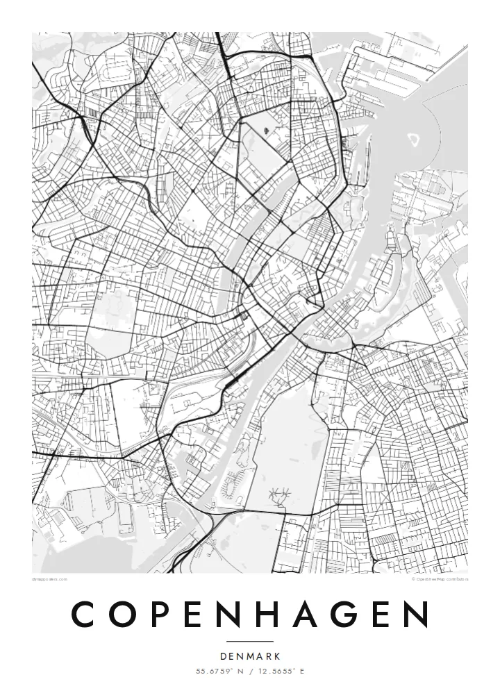
55.6759° N / 12.5655° E
A harbour city of islands, canals and a chain of rectangular lakes, with a star-shaped fortress at its edge


Inki magaala, konoy gaba
Qande inkih tibbixeeh derre baguley table. Kulli qande missoowa caagid—daabbisimta, dirbaabu-le kaadu HD fayla akah.
 Cagalah pixels · 24 × 36″ daabbi fayla
Maxxaacah qeeqa
Tama usuk cagalah daabbi faylak 100% qambaala. Kulli poster — daabbisimta, dirbaabu-le kaadu download geytimta — ni-server-ittal 300 DPI-l ederimta, 7,200 × 10,800 pixels fanah, tokkel iyyi ellee catoy 24 × 36″ daabbi baxsi bahisak raaqu.
Gidarih


Kaarta
Copenhagen is shaped by water. The inner harbour divides the old city from Christianshavn and Amager, with canals cutting through Christianshavn and the famous quay at Nyhavn. West of the centre, three long rectangular lakes, known simply as the Lakes, form a clear boundary between the historic core and the districts of Nørrebro, Østerbro and Vesterbro.
To the north, Kastellet appears as a nearly perfect pentagram of ramparts and moats, one of the best preserved fortifications in northern Europe. The old city's medieval streets meet planned eighteenth-century districts such as Frederiksstaden, and bridges tie it all together across the harbour. A Copenhagen map poster shows how elegantly land and water share the frame.
The city's growth has followed the 1947 Finger Plan, with urban corridors extending outward like fingers and green wedges between them. To the east, the Øresund Bridge links Denmark to Sweden, while Tivoli Gardens, opened in 1843, remains one of the world's oldest amusement parks.
Three elongated lakes run in a line west of the centre, a crisp geometric band of water that separates the old city from the surrounding nineteenth-century neighbourhoods.
The star-shaped citadel north of the centre is ringed by moats and bastions, one of the most graphic forms on any European city map.
Canals cut straight through Christianshavn in a tidy pattern of water and quays, echoing Amsterdam and adding fine detail beside the wider harbour.
Kok tanim ab
Ayro, migaq hinnay kok tan xagar osis; gaba, ballaqa hinnay xiqa soorris.
Free preview qansarissi kee watermark-le. Daabbisimtaan kee HD fayla 300 DPI-l, 7,200 × 10,800 px fanah, watermark maleh ederimta.
Macah Copenhagen
Copenhagen is a city of cycling routes, harbour baths and long summer evenings. A map poster suits the clean Scandinavian interiors it inspired, and makes a thoughtful keepsake of a semester, a move, or a weekend spent crossing its bridges.
Personalise the title and subtitle, add coordinates or a date, and choose between Classic black & white, Noir, Paper, Blueprint and Sand. HD files cost $9, and printed posters with an optional wooden frame ship from partners in 30+ countries.
Copenhagen poster orme| Maxxaacah ballaqa | Qeeqa | Faylal |
|---|---|---|
| 30 × 40 cm11.8 × 15.7″ | 3,543 × 4,724 px | PNG · PDF |
| 29.7 × 42 cm (A3)11.7 × 16.5″ | 3,508 × 4,961 px | PNG · PDF |
| 42 × 59.4 cm (A2)16.5 × 23.4″ | 4,961 × 7,016 px | PNG · PDF |
| 45.7 × 61 cm18 × 24″ | 5,400 × 7,200 px | PNG · PDF |
| 50 × 70 cm19.7 × 27.6″ | 5,906 × 8,268 px | PNG · PDF |
| 61 × 91.4 cm24 × 36″ | 7,200 × 10,800 px | PNG · PDF |
Tabbaltah, limo-wayta xaqqa-le ablo 900 px ballaqa le, asta le, iskiriinih keh tan. HD faylal gexsoh inkih addal 8× fanah qeeqa le, poster ballaqa inkih addal meqeh maxxaacimta.
Baxxaqqa qari le qandiy dooriy, tohuk lakal Daabbisimtah Poster — kutuk kee, faxximek, dirbaabu — hinnay HD Digital Fayla dooru. Checkout inki wagitti geytima, kaadu ku-orme page keenih adissa akke waqdi caagoy kummite.
Usuk 200 gsm-le catam kutuk warqatal, lica katiy caagitte $39-ik hane ayta 30 × 40 cm-ik 24 × 36″ fanah, xaagu keenil warreeh.
Ee. Sarrah-le dirbaabu doori — bad, gudduc, oak-le hinnay bad-madabuy. Usuk finqisiimam ellee sange qarab-le kaadu qari umukku iyya keenih taagu. Dirbaabu-le poster $99-ik hane, xaagu keenil warreeh.
Dirsa 60+ baaxoh bilsa. Poster kasa 30+ baaxoh nel print kaadu yan kee dirgeh kaxxa kee tanah printa, kee 3–7 xaqu ayyaamah yaaxigeeh. Xaaloo kee tracking "Ac Order" gexsitam. Kaadu baaxo 2–5 isbuuc yaaxigeeh, nanu dirsi yanin baaxoh sajiitah site ku kalah tekkeh.
Geytimeek 14 ayróy addal foto naah rubbaay, cisab-le daabbisiynah hinnay ku-lacay gacisnaah.
Ee. Tama page-l edito addal, migaaq, subtitle kee coordinates sarrah faxxem fanah badal, kaadu qande kee katiy doori. Daabbisimtah, dirbaabu-le kaadu digital orme inkih ku-design cagalah yekkelen.
$9 bacisak 300 DPI PNG kee daabbisimtah adissime PDF fayla lica katiy inkih, watermark maleh, ayyi meki daabbisimtah geeytitta. Cisab makkoysemty ana? Awqak, watermark-le free preview download-eh.
Xayyo
