Uraniborg site
Near the middle of the island, the site of Tycho Brahe's observatory and its reconstructed garden forms a small, deliberate geometric figure among the surrounding farmland.
Qeeqabak kaartah poster · Sweden
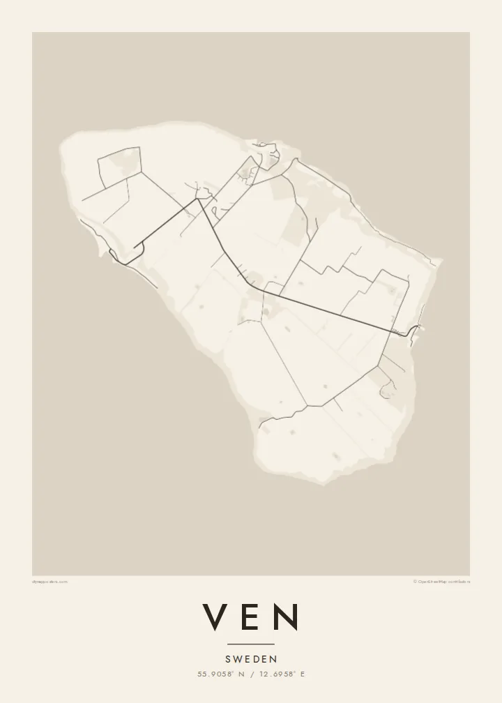
55.9058° N / 12.6958° E
A small, flat-topped island in the Øresund, ringed by steep banks and crossed by quiet lanes between open fields.




Inki magaala, konoy gaba
Qande inkih tibbixeeh derre baguley table. Kulli qande missoowa caagid—daabbisimta, dirbaabu-le kaadu HD fayla akah.
 Cagalah pixels · 24 × 36″ daabbi fayla
Maxxaacah qeeqa
Tama usuk cagalah daabbi faylak 100% qambaala. Kulli poster — daabbisimta, dirbaabu-le kaadu download geytimta — ni-server-ittal 300 DPI-l ederimta, 7,200 × 10,800 pixels fanah, tokkel iyyi ellee catoy 24 × 36″ daabbi baxsi bahisak raaqu.
Gidarih


Kaarta
Ven sits in the middle of the Øresund, the strait between Sweden and Denmark, and belongs to Landskrona municipality on the Swedish side. It is a compact oval island, a raised plateau of farmland whose steep slopes and cliffs drop to narrow beaches. From above, the patchwork of fields and the thin lanes crossing them give the interior a gentle, almost ruled texture.
The island is best known for Tycho Brahe, the Danish astronomer who was granted Ven in the 1570s and built two observatories there, Uraniborg and the partly underground Stjerneborg. His precise observations of the stars and planets later helped Johannes Kepler work out the laws of planetary motion. The site is now a museum, and its Renaissance garden has been reconstructed in a clear geometric plan.
The harbours of Bäckviken and Kyrkbacken sit on the east and west coasts respectively, and the lanes between them are mostly travelled by bicycle. A Ven map poster shows the whole island at a glance. A little of the Swedish or Danish shore at the edge hints at how close the island is to both countries, and how separate from them.
Near the middle of the island, the site of Tycho Brahe's observatory and its reconstructed garden forms a small, deliberate geometric figure among the surrounding farmland.
The plateau ends abruptly at steep grassy slopes that drop to the water, so the coastline on the map is a firm, clean edge rather than a ragged one.
The ferry from Landskrona arrives at this small east-coast harbour. From there a short road climbs off the water onto the plateau and fans out into the island's lanes.
Kok tanim ab
Ayro, migaq hinnay kok tan xagar osis; gaba, ballaqa hinnay xiqa soorris.
Free preview qansarissi kee watermark-le. Daabbisimtaan kee HD fayla 300 DPI-l, 7,200 × 10,800 px fanah, watermark maleh ederimta.
Macah Ven
Ven suits anyone drawn to the history of astronomy, and the many people who have cycled its lanes on a summer day out from Landskrona or Copenhagen. Its tidy oval shape is easy to recognise and holds a surprising amount of history for so small a place.
Personalise the title, subtitle and coordinates line, perhaps with the date of that ride or a line about Tycho, and choose one of five styles. Noir makes a fitting night sky. The files come as 300 DPI PNG and print-ready PDF in six sizes for $9, or you can order a printed poster, framed if you like.
Ven poster orme| Maxxaacah ballaqa | Qeeqa | Faylal |
|---|---|---|
| 30 × 40 cm (11.8 × 15.7″) | 3,543 × 4,724 px | PNG · PDF |
| 29.7 × 42 cm (A3, 11.7 × 16.5″) | 3,508 × 4,961 px | PNG · PDF |
| 42 × 59.4 cm (A2, 16.5 × 23.4″) | 4,961 × 7,016 px | PNG · PDF |
| 45.7 × 61 cm (18 × 24″) | 5,400 × 7,200 px | PNG · PDF |
| 50 × 70 cm (19.7 × 27.6″) | 5,906 × 8,268 px | PNG · PDF |
| 61 × 91.4 cm (24 × 36″) | 7,200 × 10,800 px | PNG · PDF |
Tabbaltah, limo-wayta xaqqa-le ablo 900 px ballaqa le, asta le, iskiriinih keh tan. HD faylal gexsoh inkih addal 8× fanah qeeqa le, poster ballaqa inkih addal meqeh maxxaacimta.
Baxxaqqa qari le qandiy dooriy, tohuk lakal Daabbisimtah Poster — kutuk kee, faxximek, dirbaabu — hinnay HD Digital Fayla dooru. Checkout inki wagitti geytima, kaadu ku-orme page keenih adissa akke waqdi caagoy kummite.
Usuk 200 gsm-le catam kutuk warqatal, lica katiy caagitte {printFrom}-ik hane ayta 30 × 40 cm-ik 24 × 36″ fanah, xaagu keenil warreeh.
Ee. Sarrah-le dirbaabu doori — bad, gudduc, oak-le hinnay bad-madabuy. Usuk finqisiimam ellee sange qarab-le kaadu qari umukku iyya keenih taagu. Dirbaabu-le poster {framedFrom}-ik hane, xaagu keenil warreeh.
Xaagu addunyal inkih cisab-le. Kulli poster 30+ ummattak ni-daabbi-mara mananih xayyoysa kaadu 3–7 caagu-ayróh fanah geeytima. Ku-orme kee xaagu tarikiy My Orders addal ablitta.
Geytimeek 14 ayróy addal foto naah rubbaay, cisab-le daabbisiynah hinnay ku-lacay gacisnaah.
Ee. Tama page-l edito addal, migaaq, subtitle kee coordinates sarrah faxxem fanah badal, kaadu qande kee katiy doori. Daabbisimtah, dirbaabu-le kaadu digital orme inkih ku-design cagalah yekkelen.
$9 bacisak 300 DPI PNG kee daabbisimtah adissime PDF fayla lica katiy inkih, watermark maleh, ayyi meki daabbisimtah geeytitta. Cisab makkoysemty ana? Awqak, watermark-le free preview download-eh.
