Leidse Rijn
The old waterway runs through the village, and the historic streets follow it. On the print it appears as a thin, steady line with buildings along both sides.
Qeeqabak kaartah poster · Netherlands
52.0817° N / 5.0361° E
A former village on the old Rhine course west of Utrecht, now framed by motorways, canals and the new Leidsche Rijn district



Inki magaala, konoy gaba
Qande inkih tibbixeeh derre baguley table. Kulli qande missoowa caagid—daabbisimta, dirbaabu-le kaadu HD fayla akah.
 Cagalah pixels · 24 × 36″ daabbi fayla
Maxxaacah qeeqa
Tama usuk cagalah daabbi faylak 100% qambaala. Kulli poster — daabbisimta, dirbaabu-le kaadu download geytimta — ni-server-ittal 300 DPI-l ederimta, 7,200 × 10,800 pixels fanah, tokkel iyyi ellee catoy 24 × 36″ daabbi baxsi bahisak raaqu.
Gidarih


Kaarta
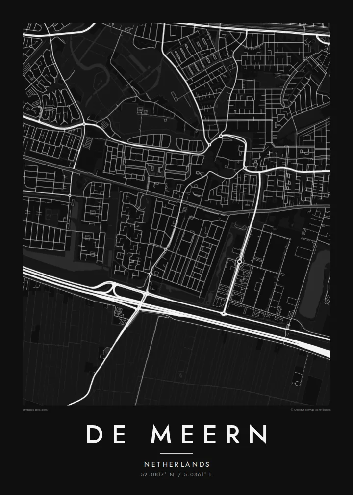
De Meern lies just west of Utrecht, part of the combined district of Vleuten-De Meern. From above, the older village follows the line of the Leidse Rijn, a waterway along an old course of the Rhine. Long, narrow streets run parallel to the water, and a straight, flat pattern of Dutch polder fields surrounds it.
That old river route was once the northern frontier of the Roman Empire. In 2003, archaeologists found a well-preserved Roman river barge here, known as De Meern 1. The nearby Roman fort site at Hoge Woerd is now marked by a reconstructed castellum. Around the village, the new Leidsche Rijn development has added large planned neighbourhoods, parks and water features.
A De Meern map poster combines different eras: a linear village along the water, modern curving neighbourhoods, straight drainage ditches and the motorways that pass nearby. It suits people who moved into the new district, those who grew up in the old village and anyone with an interest in the Roman frontier.
The old waterway runs through the village, and the historic streets follow it. On the print it appears as a thin, steady line with buildings along both sides.
The Limes once ran along this river course. The site at Hoge Woerd, where a Roman fort stood, is part of the area shown on the map.
The planned neighbourhoods of Leidsche Rijn surround the older village with parks, canals and curving streets. Together they make a sharp contrast with the linear core.
Kok tanim ab
Ayro, migaq hinnay kok tan xagar osis; gaba, ballaqa hinnay xiqa soorris.
Free preview qansarissi kee watermark-le. Daabbisimtaan kee HD fayla 300 DPI-l, 7,200 × 10,800 px fanah, watermark maleh ederimta.
Macah De Meern
Many families moved to De Meern as the new district grew, and a map marks that first home well. Longtime residents often choose it to show how the old village sits within the new city.
Put your street, family name or moving-in date in the title and subtitle, and keep the coordinates. Choose Classic black & white, Noir, Paper, Blueprint or Sand. Blueprint shows the waterways clearly.
De Meern poster orme| Maxxaacah ballaqa | Qeeqa | Faylal |
|---|---|---|
| 30 × 40 cm11.8 × 15.7″ | 3,543 × 4,724 px | PNG · PDF |
| 29.7 × 42 cm (A3)11.7 × 16.5″ | 3,508 × 4,961 px | PNG · PDF |
| 42 × 59.4 cm (A2)16.5 × 23.4″ | 4,961 × 7,016 px | PNG · PDF |
| 45.7 × 61 cm18 × 24″ | 5,400 × 7,200 px | PNG · PDF |
| 50 × 70 cm19.7 × 27.6″ | 5,906 × 8,268 px | PNG · PDF |
| 61 × 91.4 cm24 × 36″ | 7,200 × 10,800 px | PNG · PDF |
Tabbaltah, limo-wayta xaqqa-le ablo 900 px ballaqa le, asta le, iskiriinih keh tan. HD faylal gexsoh inkih addal 8× fanah qeeqa le, poster ballaqa inkih addal meqeh maxxaacimta.
Baxxaqqa qari le qandiy dooriy, tohuk lakal Daabbisimtah Poster — kutuk kee, faxximek, dirbaabu — hinnay HD Digital Fayla dooru. Checkout inki wagitti geytima, kaadu ku-orme page keenih adissa akke waqdi caagoy kummite.
Usuk 200 gsm-le catam kutuk warqatal, lica katiy caagitte $39-ik hane ayta 30 × 40 cm-ik 24 × 36″ fanah, xaagu keenil warreeh.
Ee. Sarrah-le dirbaabu doori — bad, gudduc, oak-le hinnay bad-madabuy. Usuk finqisiimam ellee sange qarab-le kaadu qari umukku iyya keenih taagu. Dirbaabu-le poster $99-ik hane, xaagu keenil warreeh.
Dirsa 60+ baaxoh bilsa. Poster kasa 30+ baaxoh nel print kaadu yan kee dirgeh kaxxa kee tanah printa, kee 3–7 xaqu ayyaamah yaaxigeeh. Xaaloo kee tracking "Ac Order" gexsitam. Kaadu baaxo 2–5 isbuuc yaaxigeeh, nanu dirsi yanin baaxoh sajiitah site ku kalah tekkeh.
Geytimeek 14 ayróy addal foto naah rubbaay, cisab-le daabbisiynah hinnay ku-lacay gacisnaah.
Ee. Tama page-l edito addal, migaaq, subtitle kee coordinates sarrah faxxem fanah badal, kaadu qande kee katiy doori. Daabbisimtah, dirbaabu-le kaadu digital orme inkih ku-design cagalah yekkelen.
$9 bacisak 300 DPI PNG kee daabbisimtah adissime PDF fayla lica katiy inkih, watermark maleh, ayyi meki daabbisimtah geeytitta. Cisab makkoysemty ana? Awqak, watermark-le free preview download-eh.
Xayyo
