Temple quarter
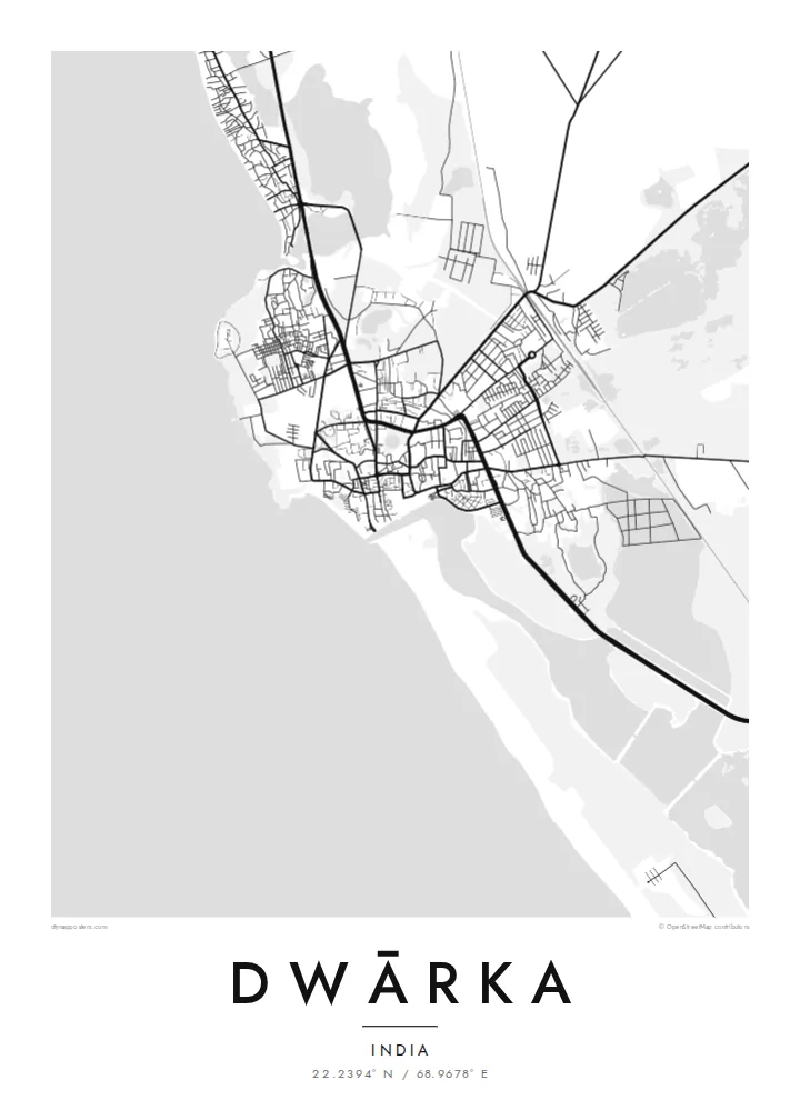
Narrow lanes cluster around the Dwarkadhish Temple near the Gomti river, forming the densest and most intricate part of the map.
Qeeqabak kaartah poster · India
22.2394° N / 68.9678° E
A temple town at the western tip of Saurashtra, where the Gomti meets the Arabian Sea and an island lies offshore


Inki magaala, konoy gaba
Qande inkih tibbixeeh derre baguley table. Kulli qande missoowa caagid—daabbisimta, dirbaabu-le kaadu HD fayla akah.
 Cagalah pixels · 24 × 36″ daabbi fayla
Maxxaacah qeeqa
Tama usuk cagalah daabbi faylak 100% qambaala. Kulli poster — daabbisimta, dirbaabu-le kaadu download geytimta — ni-server-ittal 300 DPI-l ederimta, 7,200 × 10,800 pixels fanah, tokkel iyyi ellee catoy 24 × 36″ daabbi baxsi bahisak raaqu.
Gidarih


Kaarta
Dwārka sits at the far western end of the Saurashtra peninsula in Gujarat, facing the Arabian Sea. On the map, the old town is a dense cluster of narrow lanes around the Dwarkadhish Temple, near the point where the Gomti river meets the sea. Beyond the old centre the streets become more open, and the coast curves away in both directions, rocky in places and sandy in others.
Dwārka is one of the four Char Dham pilgrimage sites of Hinduism, associated in tradition with Krishna, and draws large numbers of pilgrims every year. Just offshore to the north lies Beyt Dwarka, an island with its own temples, which since 2024 has been connected to the mainland by the Sudarshan Setu, a long cable-stayed bridge.
A Dwārka map poster shows a sacred city defined by its edges: the sea to the west, the river mouth, the tight maze of the old town and the coastline running north toward the island. In black and white, the dense lanes around the temple stand out clearly against the broad, empty expanse of the sea.
Narrow lanes cluster around the Dwarkadhish Temple near the Gomti river, forming the densest and most intricate part of the map.
The Gomti meets the Arabian Sea right beside the old town, where the ghats and the temple face the water.
The shoreline runs along the western edge of the peninsula, rocky and irregular, giving the map a strong and dramatic edge.
Kok tanim ab
Ayro, migaq hinnay kok tan xagar osis; gaba, ballaqa hinnay xiqa soorris.
Free preview qansarissi kee watermark-le. Daabbisimtaan kee HD fayla 300 DPI-l, 7,200 × 10,800 px fanah, watermark maleh ederimta.
Macah Dwārka
For pilgrims, families from Gujarat and anyone who has walked from the temple down to the Gomti ghats, Dwārka carries deep personal meaning. The map is a respectful way to keep that journey close at home.
Add the date of your pilgrimage or a family name to the title, edit the subtitle and coordinates, and choose one of five styles. The $9 download covers six print sizes, each as a 300 DPI PNG and PDF.
Dwārka poster orme| Maxxaacah ballaqa | Qeeqa | Faylal |
|---|---|---|
| 30 × 40 cm (11.8 × 15.7″) | 3,543 × 4,724 px | PNG · PDF |
| 29.7 × 42 cm (A3, 11.7 × 16.5″) | 3,508 × 4,961 px | PNG · PDF |
| 42 × 59.4 cm (A2, 16.5 × 23.4″) | 4,961 × 7,016 px | PNG · PDF |
| 45.7 × 61 cm (18 × 24″) | 5,400 × 7,200 px | PNG · PDF |
| 50 × 70 cm (19.7 × 27.6″) | 5,906 × 8,268 px | PNG · PDF |
| 61 × 91.4 cm (24 × 36″) | 7,200 × 10,800 px | PNG · PDF |
Tabbaltah, limo-wayta xaqqa-le ablo 900 px ballaqa le, asta le, iskiriinih keh tan. HD faylal gexsoh inkih addal 8× fanah qeeqa le, poster ballaqa inkih addal meqeh maxxaacimta.
Baxxaqqa qari le qandiy dooriy, tohuk lakal Daabbisimtah Poster — kutuk kee, faxximek, dirbaabu — hinnay HD Digital Fayla dooru. Checkout inki wagitti geytima, kaadu ku-orme page keenih adissa akke waqdi caagoy kummite.
Usuk 200 gsm-le catam kutuk warqatal, lica katiy caagitte {printFrom}-ik hane ayta 30 × 40 cm-ik 24 × 36″ fanah, xaagu keenil warreeh.
Ee. Sarrah-le dirbaabu doori — bad, gudduc, oak-le hinnay bad-madabuy. Usuk finqisiimam ellee sange qarab-le kaadu qari umukku iyya keenih taagu. Dirbaabu-le poster {framedFrom}-ik hane, xaagu keenil warreeh.
Xaagu addunyal inkih cisab-le. Kulli poster 30+ ummattak ni-daabbi-mara mananih xayyoysa kaadu 3–7 caagu-ayróh fanah geeytima. Ku-orme kee xaagu tarikiy My Orders addal ablitta.
Geytimeek 14 ayróy addal foto naah rubbaay, cisab-le daabbisiynah hinnay ku-lacay gacisnaah.
Ee. Tama page-l edito addal, migaaq, subtitle kee coordinates sarrah faxxem fanah badal, kaadu qande kee katiy doori. Daabbisimtah, dirbaabu-le kaadu digital orme inkih ku-design cagalah yekkelen.
$9 bacisak 300 DPI PNG kee daabbisimtah adissime PDF fayla lica katiy inkih, watermark maleh, ayyi meki daabbisimtah geeytitta. Cisab makkoysemty ana? Awqak, watermark-le free preview download-eh.
Xayyo
