Euripus Strait
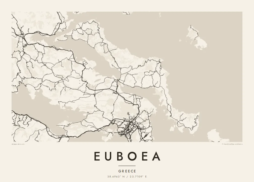
At Chalkida the channel between the island and the mainland narrows to a few dozen metres, and two bridges cross it. This tiny gap in the coastline defines the whole map.
Qeeqabak kaartah poster · Greece
38.4943° N / 23.7109° E
A long, narrow island lying parallel to the Greek mainland, joined to it by bridges across a strait only metres wide




Inki magaala, konoy gaba
Qande inkih tibbixeeh derre baguley table. Kulli qande missoowa caagid—daabbisimta, dirbaabu-le kaadu HD fayla akah.
 Cagalah pixels · 24 × 36″ daabbi fayla
Maxxaacah qeeqa
Tama usuk cagalah daabbi faylak 100% qambaala. Kulli poster — daabbisimta, dirbaabu-le kaadu download geytimta — ni-server-ittal 300 DPI-l ederimta, 7,200 × 10,800 pixels fanah, tokkel iyyi ellee catoy 24 × 36″ daabbi baxsi bahisak raaqu.
Gidarih


Kaarta
Euboea is the second-largest island in Greece after Crete. It stretches for well over a hundred kilometres along the mainland coast northeast of Athens. On a map it is long, narrow and mountainous, and its axis mirrors the shape of the coast opposite. The North and South Euboean Gulfs lie between the two shores and almost close up at Chalkida, near the island's midpoint.
Chalkida, the largest town, sits at the narrowest point of the strait, the Euripus, where two bridges link the island to the mainland. The currents in the channel are well known: they change direction several times a day and have puzzled writers since ancient times. The town's streets fan out from the waterfront, and the mainland shore is only a short distance away.
The north of the island has long been known for its pine forests. The centre rises to the high peak of Dirfys, and the south narrows into a dry, rugged peninsula that ends near Karystos. Villages and small ports line both coasts, linked by roads that wind through the mountains. A Euboea map poster shows an island that feels almost part of the mainland, divided from it by a thread of sea.
At Chalkida the channel between the island and the mainland narrows to a few dozen metres, and two bridges cross it. This tiny gap in the coastline defines the whole map.
The island's highest mountain rises in central Euboea and gathers the contour lines tightly. Small roads climb to villages on its slopes and drop down to the east coast.
South of its midpoint, Euboea narrows into a long, mountainous arm that reaches toward Andros. It ends in a coast of small bays around Karystos.
Kok tanim ab
Ayro, migaq hinnay kok tan xagar osis; gaba, ballaqa hinnay xiqa soorris.
Free preview qansarissi kee watermark-le. Daabbisimtaan kee HD fayla 300 DPI-l, 7,200 × 10,800 px fanah, watermark maleh ederimta.
Macah Euboea
For many Athenians, Euboea is a place of summer homes and family villages, and it is a quieter alternative to the better-known islands. Its long profile and the fine thread of the Euripus make it a striking shape on the wall.
You can write your own title and subtitle, perhaps naming a village or a year, and adjust the coordinates line. Choose from Classic black and white, Noir, Paper, Blueprint and Sand, then order a printed poster or download the HD files for $9.
Euboea poster orme| Maxxaacah ballaqa | Qeeqa | Faylal |
|---|---|---|
| 30 × 40 cm (11.8 × 15.7″) | 3,543 × 4,724 px | PNG · PDF |
| 29.7 × 42 cm (A3, 11.7 × 16.5″) | 3,508 × 4,961 px | PNG · PDF |
| 42 × 59.4 cm (A2, 16.5 × 23.4″) | 4,961 × 7,016 px | PNG · PDF |
| 45.7 × 61 cm (18 × 24″) | 5,400 × 7,200 px | PNG · PDF |
| 50 × 70 cm (19.7 × 27.6″) | 5,906 × 8,268 px | PNG · PDF |
| 61 × 91.4 cm (24 × 36″) | 7,200 × 10,800 px | PNG · PDF |
Tabbaltah, limo-wayta xaqqa-le ablo 900 px ballaqa le, asta le, iskiriinih keh tan. HD faylal gexsoh inkih addal 8× fanah qeeqa le, poster ballaqa inkih addal meqeh maxxaacimta.
Baxxaqqa qari le qandiy dooriy, tohuk lakal Daabbisimtah Poster — kutuk kee, faxximek, dirbaabu — hinnay HD Digital Fayla dooru. Checkout inki wagitti geytima, kaadu ku-orme page keenih adissa akke waqdi caagoy kummite.
Usuk 200 gsm-le catam kutuk warqatal, lica katiy caagitte $39-ik hane ayta 30 × 40 cm-ik 24 × 36″ fanah, xaagu keenil warreeh.
Ee. Sarrah-le dirbaabu doori — bad, gudduc, oak-le hinnay bad-madabuy. Usuk finqisiimam ellee sange qarab-le kaadu qari umukku iyya keenih taagu. Dirbaabu-le poster $99-ik hane, xaagu keenil warreeh.
Shipping is free worldwide. Each poster is printed by the nearest of our print partners in 30+ countries and usually arrives in 3–7 business days. You can follow the status and tracking under My Orders. A few countries take 2–5 weeks, and where we don't ship yet, the site tells you before you pay.
Geytimeek 14 ayróy addal foto naah rubbaay, cisab-le daabbisiynah hinnay ku-lacay gacisnaah.
Ee. Tama page-l edito addal, migaaq, subtitle kee coordinates sarrah faxxem fanah badal, kaadu qande kee katiy doori. Daabbisimtah, dirbaabu-le kaadu digital orme inkih ku-design cagalah yekkelen.
$9 bacisak 300 DPI PNG kee daabbisimtah adissime PDF fayla lica katiy inkih, watermark maleh, ayyi meki daabbisimtah geeytitta. Cisab makkoysemty ana? Awqak, watermark-le free preview download-eh.
Xayyo
