Hilltop old town
The historic centre sits on a small rise, with narrow streets curving around the cathedral. It contrasts clearly with the newer grid near the coast.
Qeeqabak kaartah poster · France
43.4333° N / 6.7355° E
A Roman port town on the Riviera, stretching from hilltop old streets to a marina and long beaches below the Esterel




Inki magaala, konoy gaba
Qande inkih tibbixeeh derre baguley table. Kulli qande missoowa caagid—daabbisimta, dirbaabu-le kaadu HD fayla akah.
 Cagalah pixels · 24 × 36″ daabbi fayla
Maxxaacah qeeqa
Tama usuk cagalah daabbi faylak 100% qambaala. Kulli poster — daabbisimta, dirbaabu-le kaadu download geytimta — ni-server-ittal 300 DPI-l ederimta, 7,200 × 10,800 pixels fanah, tokkel iyyi ellee catoy 24 × 36″ daabbi baxsi bahisak raaqu.
Gidarih


Kaarta
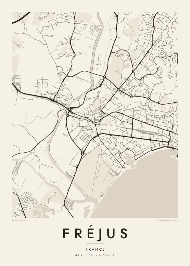
Fréjus lies on the Mediterranean coast of the Var, next to Saint-Raphaël, with which it forms a continuous urban area. On a map, the old town sits on a slight rise inland, with tight, winding streets around the cathedral. Below it, more recent districts spread toward the sea, where a long beach and the modern marina of Port-Fréjus front the bay.
The town was founded by Julius Caesar as Forum Julii and became an important Roman naval base. Several Roman structures remain, including an amphitheatre, parts of the walls and the remains of an aqueduct, and their outlines are part of the street pattern. The cathedral and its baptistery form one of the oldest episcopal groups in France.
A Fréjus map poster shows how the town lies between the Argens delta to the west and the red volcanic Esterel massif to the east. In 1959, the Malpasset dam north of the town failed and caused a deadly flood that remains a defining event in the town's modern history.
The historic centre sits on a small rise, with narrow streets curving around the cathedral. It contrasts clearly with the newer grid near the coast.
The amphitheatre, fragments of the walls and the aqueduct leave recognisable shapes in and around the town, traces of Roman Forum Julii.
The modern marina and a long beach line the bay. The sharp coastline and the harbour basins give the south of the map a strong edge.
Kok tanim ab
Ayro, migaq hinnay kok tan xagar osis; gaba, ballaqa hinnay xiqa soorris.
Free preview qansarissi kee watermark-le. Daabbisimtaan kee HD fayla 300 DPI-l, 7,200 × 10,800 px fanah, watermark maleh ederimta.
Macah Fréjus
The poster suits holidaymakers who return to the Var every summer, readers of Roman history, and anyone with a home on this part of the Riviera. The coastline and the old core make a balanced composition.
You can personalise the title, subtitle and coordinates, for example with the year of a holiday, and choose from five styles: Classic black & white, Noir, Paper, Blueprint and Sand. Blueprint suits the marina and bay particularly well.
Fréjus poster orme| Maxxaacah ballaqa | Qeeqa | Faylal |
|---|---|---|
| 30 × 40 cm (11.8 × 15.7″) | 3,543 × 4,724 px | PNG · PDF |
| 29.7 × 42 cm (A3, 11.7 × 16.5″) | 3,508 × 4,961 px | PNG · PDF |
| 42 × 59.4 cm (A2, 16.5 × 23.4″) | 4,961 × 7,016 px | PNG · PDF |
| 45.7 × 61 cm (18 × 24″) | 5,400 × 7,200 px | PNG · PDF |
| 50 × 70 cm (19.7 × 27.6″) | 5,906 × 8,268 px | PNG · PDF |
| 61 × 91.4 cm (24 × 36″) | 7,200 × 10,800 px | PNG · PDF |
Tabbaltah, limo-wayta xaqqa-le ablo 900 px ballaqa le, asta le, iskiriinih keh tan. HD faylal gexsoh inkih addal 8× fanah qeeqa le, poster ballaqa inkih addal meqeh maxxaacimta.
Baxxaqqa qari le qandiy dooriy, tohuk lakal Daabbisimtah Poster — kutuk kee, faxximek, dirbaabu — hinnay HD Digital Fayla dooru. Checkout inki wagitti geytima, kaadu ku-orme page keenih adissa akke waqdi caagoy kummite.
Usuk 200 gsm-le catam kutuk warqatal, lica katiy caagitte {printFrom}-ik hane ayta 30 × 40 cm-ik 24 × 36″ fanah, xaagu keenil warreeh.
Ee. Sarrah-le dirbaabu doori — bad, gudduc, oak-le hinnay bad-madabuy. Usuk finqisiimam ellee sange qarab-le kaadu qari umukku iyya keenih taagu. Dirbaabu-le poster {framedFrom}-ik hane, xaagu keenil warreeh.
Xaagu addunyal inkih cisab-le. Kulli poster 30+ ummattak ni-daabbi-mara mananih xayyoysa kaadu 3–7 caagu-ayróh fanah geeytima. Ku-orme kee xaagu tarikiy My Orders addal ablitta.
Geytimeek 14 ayróy addal foto naah rubbaay, cisab-le daabbisiynah hinnay ku-lacay gacisnaah.
Ee. Tama page-l edito addal, migaaq, subtitle kee coordinates sarrah faxxem fanah badal, kaadu qande kee katiy doori. Daabbisimtah, dirbaabu-le kaadu digital orme inkih ku-design cagalah yekkelen.
$9 bacisak 300 DPI PNG kee daabbisimtah adissime PDF fayla lica katiy inkih, watermark maleh, ayyi meki daabbisimtah geeytitta. Cisab makkoysemty ana? Awqak, watermark-le free preview download-eh.
