Galata Bridge
The lowest crossing near the mouth links Eminönü with Karaköy. It is the busiest point on the water, and its outline marks the entrance to the inlet.
Qeeqabak kaartah poster · Türkiye
41.0412° N / 28.9551° E
A long, curved estuary cutting into Istanbul's European side, crossed by bridges and lined on both banks with old quarters


Inki magaala, konoy gaba
Qande inkih tibbixeeh derre baguley table. Kulli qande missoowa caagid—daabbisimta, dirbaabu-le kaadu HD fayla akah.
 Cagalah pixels · 24 × 36″ daabbi fayla
Maxxaacah qeeqa
Tama usuk cagalah daabbi faylak 100% qambaala. Kulli poster — daabbisimta, dirbaabu-le kaadu download geytimta — ni-server-ittal 300 DPI-l ederimta, 7,200 × 10,800 pixels fanah, tokkel iyyi ellee catoy 24 × 36″ daabbi baxsi bahisak raaqu.
Gidarih


Kaarta
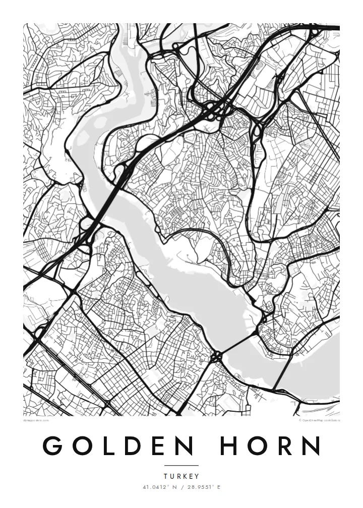
The Golden Horn is a narrow inlet that curves north-west from the Bosphorus for several kilometres. It separates Istanbul's historic peninsula from Galata and Beyoğlu on the far shore. On a map, its shape explains the name: a slender, horn-like body of water, wide at the mouth and tapering inland, where two streams feed into it.
For centuries this was one of the finest natural harbours in the Mediterranean world. In Byzantine times, a great chain was stretched across its mouth to keep enemy fleets out. The shores were later lined with shipyards, warehouses and dense neighbourhoods such as Fener and Balat, whose streets still come right down to the water on the southern bank.
Today several bridges cross the inlet, from the Galata Bridge near the mouth to the Atatürk Bridge and the Haliç metro bridge further in. A Golden Horn map poster places water at the centre of the composition. The city presses in from both sides, and the bridges stitch the two halves together in a series of fine lines.
The lowest crossing near the mouth links Eminönü with Karaköy. It is the busiest point on the water, and its outline marks the entrance to the inlet.
The inlet bends gently as it narrows inland. This gives the map a long, sweeping body of water rather than the straight line of a river.
These historic neighbourhoods on the southern bank climb from the waterline in a tight mesh of streets. They show how closely the old city once lived with the harbour.
Kok tanim ab
Ayro, migaq hinnay kok tan xagar osis; gaba, ballaqa hinnay xiqa soorris.
Free preview qansarissi kee watermark-le. Daabbisimtaan kee HD fayla 300 DPI-l, 7,200 × 10,800 px fanah, watermark maleh ederimta.
Macah Golden Horn
Anyone who has crossed the Galata Bridge at dusk or taken a ferry up the inlet knows how much of Istanbul is defined by water. This map puts the Golden Horn at the centre, just as the city does.
You can change the title, subtitle and coordinates line to mark a trip, a move or a family story. Pick one of five styles. Blueprint emphasises the water as a clean field, while Noir makes the shorelines glow against a dark ground.
Golden Horn poster orme| Maxxaacah ballaqa | Qeeqa | Faylal |
|---|---|---|
| 30 × 40 cm11.8 × 15.7″ | 3,543 × 4,724 px | PNG · PDF |
| 29.7 × 42 cm (A3)11.7 × 16.5″ | 3,508 × 4,961 px | PNG · PDF |
| 42 × 59.4 cm (A2)16.5 × 23.4″ | 4,961 × 7,016 px | PNG · PDF |
| 45.7 × 61 cm18 × 24″ | 5,400 × 7,200 px | PNG · PDF |
| 50 × 70 cm19.7 × 27.6″ | 5,906 × 8,268 px | PNG · PDF |
| 61 × 91.4 cm24 × 36″ | 7,200 × 10,800 px | PNG · PDF |
Tabbaltah, limo-wayta xaqqa-le ablo 900 px ballaqa le, asta le, iskiriinih keh tan. HD faylal gexsoh inkih addal 8× fanah qeeqa le, poster ballaqa inkih addal meqeh maxxaacimta.
Baxxaqqa qari le qandiy dooriy, tohuk lakal Daabbisimtah Poster — kutuk kee, faxximek, dirbaabu — hinnay HD Digital Fayla dooru. Checkout inki wagitti geytima, kaadu ku-orme page keenih adissa akke waqdi caagoy kummite.
Usuk 200 gsm-le catam kutuk warqatal, lica katiy caagitte $39-ik hane ayta 30 × 40 cm-ik 24 × 36″ fanah, xaagu keenil warreeh.
Ee. Sarrah-le dirbaabu doori — bad, gudduc, oak-le hinnay bad-madabuy. Usuk finqisiimam ellee sange qarab-le kaadu qari umukku iyya keenih taagu. Dirbaabu-le poster $99-ik hane, xaagu keenil warreeh.
Dirsa 60+ baaxoh bilsa. Poster kasa 30+ baaxoh nel print kaadu yan kee dirgeh kaxxa kee tanah printa, kee 3–7 xaqu ayyaamah yaaxigeeh. Xaaloo kee tracking "Ac Order" gexsitam. Kaadu baaxo 2–5 isbuuc yaaxigeeh, nanu dirsi yanin baaxoh sajiitah site ku kalah tekkeh.
Geytimeek 14 ayróy addal foto naah rubbaay, cisab-le daabbisiynah hinnay ku-lacay gacisnaah.
Ee. Tama page-l edito addal, migaaq, subtitle kee coordinates sarrah faxxem fanah badal, kaadu qande kee katiy doori. Daabbisimtah, dirbaabu-le kaadu digital orme inkih ku-design cagalah yekkelen.
$9 bacisak 300 DPI PNG kee daabbisimtah adissime PDF fayla lica katiy inkih, watermark maleh, ayyi meki daabbisimtah geeytitta. Cisab makkoysemty ana? Awqak, watermark-le free preview download-eh.
Xayyo
