Valley roads
The main routes run along valley bottoms, bending with the terrain rather than following a grid, so the strongest lines on the map trace the shape of the land beneath them.
Qeeqabak kaartah poster · Japan
34.0262° N / 135.2528° E
A small settlement in the folded hills of western Wakayama, where roads follow valley floors between terraced slopes.




Inki magaala, konoy gaba
Qande inkih tibbixeeh derre baguley table. Kulli qande missoowa caagid—daabbisimta, dirbaabu-le kaadu HD fayla akah.
 Cagalah pixels · 24 × 36″ daabbi fayla
Maxxaacah qeeqa
Tama usuk cagalah daabbi faylak 100% qambaala. Kulli poster — daabbisimta, dirbaabu-le kaadu download geytimta — ni-server-ittal 300 DPI-l ederimta, 7,200 × 10,800 pixels fanah, tokkel iyyi ellee catoy 24 × 36″ daabbi baxsi bahisak raaqu.
Gidarih


Kaarta
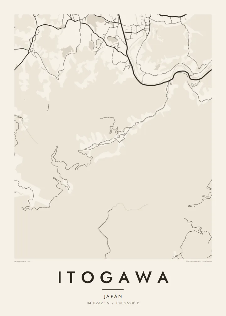
Itogawa is a small place in Wakayama Prefecture, on the western side of the Kii Peninsula. The land here is rarely flat for long: hills rise close on every side, and settlements tend to follow the narrow valleys where there is room for houses, fields and a road. On a map that produces a shape quite unlike a planned city, long and threaded rather than square.
Wakayama is best known in Japan for its citrus, and the prefecture is the country's leading producer of mikan mandarins, many of them grown on slopes facing the sea. It is also home to the Kumano pilgrimage routes and the temple settlement of Mount Kōya, both further inland and both part of a UNESCO World Heritage listing.
An Itogawa map poster captures the way people have fitted streets into terrain. Roads bend with the contours, lanes branch off into side valleys and stop, and small clusters of buildings appear wherever the ground allows. The result is an organic, almost hand-drawn pattern that feels closer to a landscape study than to a conventional city plan.
The main routes run along valley bottoms, bending with the terrain rather than following a grid, so the strongest lines on the map trace the shape of the land beneath them.
Narrow lanes climb away from the main roads toward farms and orchards on the slopes, ending in short spurs that give the edges of the map a fine, branching texture.
Large blank areas between the built-up clusters stand for forested hills and farmland, and they give the composition generous breathing room that suits a minimalist print.
Kok tanim ab
Ayro, migaq hinnay kok tan xagar osis; gaba, ballaqa hinnay xiqa soorris.
Free preview qansarissi kee watermark-le. Daabbisimtaan kee HD fayla 300 DPI-l, 7,200 × 10,800 px fanah, watermark maleh ederimta.
Macah Itogawa
This is a map for someone with a personal link to the area, whether through family, a stay in the countryside or a trip along the Wakayama coast. Its winding, uneven lines have a calm quality that sits well in a study, bedroom or entrance hall.
The title, subtitle and coordinates can all be changed, so the print can carry a family name and a date that matters. Choose Classic black & white, Noir, Paper, Blueprint or Sand, and check a free 900 px preview before buying.
Itogawa poster orme| Maxxaacah ballaqa | Qeeqa | Faylal |
|---|---|---|
| 30 × 40 cm (11.8 × 15.7″) | 3,543 × 4,724 px | PNG · PDF |
| 29.7 × 42 cm (A3, 11.7 × 16.5″) | 3,508 × 4,961 px | PNG · PDF |
| 42 × 59.4 cm (A2, 16.5 × 23.4″) | 4,961 × 7,016 px | PNG · PDF |
| 45.7 × 61 cm (18 × 24″) | 5,400 × 7,200 px | PNG · PDF |
| 50 × 70 cm (19.7 × 27.6″) | 5,906 × 8,268 px | PNG · PDF |
| 61 × 91.4 cm (24 × 36″) | 7,200 × 10,800 px | PNG · PDF |
Tabbaltah, limo-wayta xaqqa-le ablo 900 px ballaqa le, asta le, iskiriinih keh tan. HD faylal gexsoh inkih addal 8× fanah qeeqa le, poster ballaqa inkih addal meqeh maxxaacimta.
Baxxaqqa qari le qandiy dooriy, tohuk lakal Daabbisimtah Poster — kutuk kee, faxximek, dirbaabu — hinnay HD Digital Fayla dooru. Checkout inki wagitti geytima, kaadu ku-orme page keenih adissa akke waqdi caagoy kummite.
Usuk 200 gsm-le catam kutuk warqatal, lica katiy caagitte $39-ik hane ayta 30 × 40 cm-ik 24 × 36″ fanah, xaagu keenil warreeh.
Ee. Sarrah-le dirbaabu doori — bad, gudduc, oak-le hinnay bad-madabuy. Usuk finqisiimam ellee sange qarab-le kaadu qari umukku iyya keenih taagu. Dirbaabu-le poster $99-ik hane, xaagu keenil warreeh.
Shipping is free worldwide. Each poster is printed by the nearest of our print partners in 30+ countries and usually arrives in 3–7 business days. You can follow the status and tracking under My Orders. A few countries take 2–5 weeks, and where we don't ship yet, the site tells you before you pay.
Geytimeek 14 ayróy addal foto naah rubbaay, cisab-le daabbisiynah hinnay ku-lacay gacisnaah.
Ee. Tama page-l edito addal, migaaq, subtitle kee coordinates sarrah faxxem fanah badal, kaadu qande kee katiy doori. Daabbisimtah, dirbaabu-le kaadu digital orme inkih ku-design cagalah yekkelen.
$9 bacisak 300 DPI PNG kee daabbisimtah adissime PDF fayla lica katiy inkih, watermark maleh, ayyi meki daabbisimtah geeytitta. Cisab makkoysemty ana? Awqak, watermark-le free preview download-eh.
