Kinokawa River
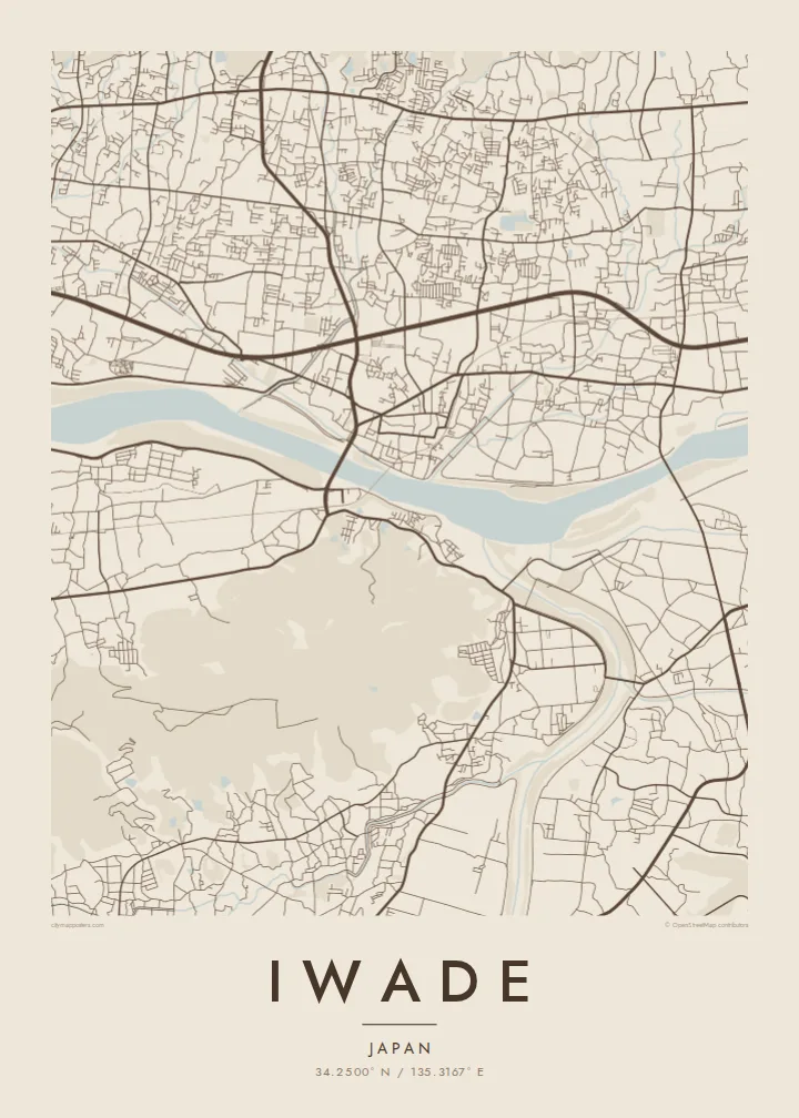
The wide river crosses the southern part of the city with its broad bed and embankments. It is the strongest line on the map.
Qeeqabak kaartah poster · Japan
34.2500° N / 135.3167° E
A Wakayama city on the Kinokawa plain, between the river's broad course and the forested Izumi mountains


Inki magaala, konoy gaba
Qande inkih tibbixeeh derre baguley table. Kulli qande missoowa caagid—daabbisimta, dirbaabu-le kaadu HD fayla akah.
 Cagalah pixels · 24 × 36″ daabbi fayla
Maxxaacah qeeqa
Tama usuk cagalah daabbi faylak 100% qambaala. Kulli poster — daabbisimta, dirbaabu-le kaadu download geytimta — ni-server-ittal 300 DPI-l ederimta, 7,200 × 10,800 pixels fanah, tokkel iyyi ellee catoy 24 × 36″ daabbi baxsi bahisak raaqu.
Gidarih


Kaarta
Iwade lies in northern Wakayama prefecture, in the valley of the Kinokawa River. From above, the city divides into clear bands. The wide river runs across the southern part with its broad bed and embankments. Built-up areas and farmland fill the level ground to the north, and the land rises towards the wooded Izumi mountains on the border with Osaka.
The city is known for Negoro-ji, the head temple of the Shingi branch of Shingon Buddhism. Its large grounds on the lower slopes of the mountains include the Daito, a great two-storey pagoda designated a National Treasure. In the Middle Ages the temple held great power, and its warrior monks were famous. The surrounding hills are known for autumn colour.
An Iwade map poster shows the transition from river to plain to mountain: the Kinokawa's broad line, a mix of residential streets and fields in the middle, and forested slopes where the temple sits at the edge. It is a calm, balanced print for anyone connected to this part of Wakayama.
The wide river crosses the southern part of the city with its broad bed and embankments. It is the strongest line on the map.
The large temple precinct sits at the foot of the mountains. It shows as a distinct area of paths and buildings between the town and the forest.
Wooded slopes rise to the north towards the border with Osaka. They frame the plain and give the map a firm upper edge.
Kok tanim ab
Ayro, migaq hinnay kok tan xagar osis; gaba, ballaqa hinnay xiqa soorris.
Free preview qansarissi kee watermark-le. Daabbisimtaan kee HD fayla 300 DPI-l, 7,200 × 10,800 px fanah, watermark maleh ederimta.
Macah Iwade
Iwade is where river, farmland and mountain temple meet, and many people carry it with them as a hometown. A map of it is a thoughtful print to hang in a new home or give as a gift.
Set the title, subtitle and coordinates line in Japanese or English, then choose Classic black & white, Noir, Paper, Blueprint or Sand. Paper gives a soft effect that suits the temple and the hills.
Iwade poster orme| Maxxaacah ballaqa | Qeeqa | Faylal |
|---|---|---|
| 30 × 40 cm (11.8 × 15.7″) | 3,543 × 4,724 px | PNG · PDF |
| 29.7 × 42 cm (A3, 11.7 × 16.5″) | 3,508 × 4,961 px | PNG · PDF |
| 42 × 59.4 cm (A2, 16.5 × 23.4″) | 4,961 × 7,016 px | PNG · PDF |
| 45.7 × 61 cm (18 × 24″) | 5,400 × 7,200 px | PNG · PDF |
| 50 × 70 cm (19.7 × 27.6″) | 5,906 × 8,268 px | PNG · PDF |
| 61 × 91.4 cm (24 × 36″) | 7,200 × 10,800 px | PNG · PDF |
Tabbaltah, limo-wayta xaqqa-le ablo 900 px ballaqa le, asta le, iskiriinih keh tan. HD faylal gexsoh inkih addal 8× fanah qeeqa le, poster ballaqa inkih addal meqeh maxxaacimta.
Baxxaqqa qari le qandiy dooriy, tohuk lakal Daabbisimtah Poster — kutuk kee, faxximek, dirbaabu — hinnay HD Digital Fayla dooru. Checkout inki wagitti geytima, kaadu ku-orme page keenih adissa akke waqdi caagoy kummite.
Usuk 200 gsm-le catam kutuk warqatal, lica katiy caagitte {printFrom}-ik hane ayta 30 × 40 cm-ik 24 × 36″ fanah, xaagu keenil warreeh.
Ee. Sarrah-le dirbaabu doori — bad, gudduc, oak-le hinnay bad-madabuy. Usuk finqisiimam ellee sange qarab-le kaadu qari umukku iyya keenih taagu. Dirbaabu-le poster {framedFrom}-ik hane, xaagu keenil warreeh.
Xaagu addunyal inkih cisab-le. Kulli poster 30+ ummattak ni-daabbi-mara mananih xayyoysa kaadu 3–7 caagu-ayróh fanah geeytima. Ku-orme kee xaagu tarikiy My Orders addal ablitta.
Geytimeek 14 ayróy addal foto naah rubbaay, cisab-le daabbisiynah hinnay ku-lacay gacisnaah.
Ee. Tama page-l edito addal, migaaq, subtitle kee coordinates sarrah faxxem fanah badal, kaadu qande kee katiy doori. Daabbisimtah, dirbaabu-le kaadu digital orme inkih ku-design cagalah yekkelen.
$9 bacisak 300 DPI PNG kee daabbisimtah adissime PDF fayla lica katiy inkih, watermark maleh, ayyi meki daabbisimtah geeytitta. Cisab makkoysemty ana? Awqak, watermark-le free preview download-eh.
