Kemijoki delta
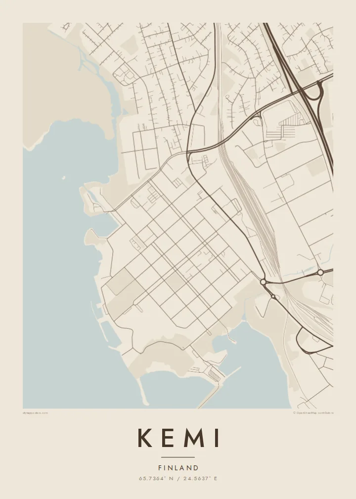
Finland's longest river reaches the sea here, dividing into several channels around islands. These branching arms take up much of the eastern side of the map.
Qeeqabak kaartah poster · Finland
65.7364° N / 24.5637° E
A Lapland port at the mouth of the Kemijoki, where river channels, islands and harbours meet the frozen Gulf of Bothnia.


Inki magaala, konoy gaba
Qande inkih tibbixeeh derre baguley table. Kulli qande missoowa caagid—daabbisimta, dirbaabu-le kaadu HD fayla akah.
 Cagalah pixels · 24 × 36″ daabbi fayla
Maxxaacah qeeqa
Tama usuk cagalah daabbi faylak 100% qambaala. Kulli poster — daabbisimta, dirbaabu-le kaadu download geytimta — ni-server-ittal 300 DPI-l ederimta, 7,200 × 10,800 pixels fanah, tokkel iyyi ellee catoy 24 × 36″ daabbi baxsi bahisak raaqu.
Gidarih


Kaarta
Kemi is on the northern shore of the Gulf of Bothnia, at the mouth of the Kemijoki, the longest river in Finland. The city sits on a peninsula and islands between the river's delta channels and the sea. On a map, water surrounds it: branching river arms to the east, open gulf to the south and west, and deep-water harbours along the shoreline.
The centre has a clear grid of streets near the waterfront, and industrial areas of pulp and paper mills spread out along the shore. In winter the sea freezes, and Kemi has become known for icebreaker cruises on the Sampo and for a snow castle rebuilt each year. South of the centre, the Ajos headland reaches out toward the open water.
A Kemi map poster shows a city defined by river and sea: the delta channels, the harbour piers, the grid of the centre and the islands scattered offshore. In black and white, the shoreline looks almost like an ice chart. It suits northerners and anyone who has visited Lapland in the frozen months and remembers the flat white horizon.
Finland's longest river reaches the sea here, dividing into several channels around islands. These branching arms take up much of the eastern side of the map.
Piers, mills and port basins line the coast. Their straight, engineered edges contrast with the natural curves of the river channels nearby.
A long headland south of the centre stretches into the Gulf of Bothnia, leading the map's composition toward open water and the sea ice.
Kok tanim ab
Ayro, migaq hinnay kok tan xagar osis; gaba, ballaqa hinnay xiqa soorris.
Free preview qansarissi kee watermark-le. Daabbisimtaan kee HD fayla 300 DPI-l, 7,200 × 10,800 px fanah, watermark maleh ederimta.
Macah Kemi
Kemi's map is mostly water, and that gives it a rare graphic quality. It suits a Nordic interior and a minimal room, and it makes a quiet memento of a winter journey to Lapland.
You can personalise the title, subtitle and coordinates line, and choose one of five styles. Blueprint suits the harbour and Noir suits the polar night. The free 900 px preview lets you compare them before you buy the $9 HD files.
Kemi poster orme| Maxxaacah ballaqa | Qeeqa | Faylal |
|---|---|---|
| 30 × 40 cm (11.8 × 15.7″) | 3,543 × 4,724 px | PNG · PDF |
| 29.7 × 42 cm (A3, 11.7 × 16.5″) | 3,508 × 4,961 px | PNG · PDF |
| 42 × 59.4 cm (A2, 16.5 × 23.4″) | 4,961 × 7,016 px | PNG · PDF |
| 45.7 × 61 cm (18 × 24″) | 5,400 × 7,200 px | PNG · PDF |
| 50 × 70 cm (19.7 × 27.6″) | 5,906 × 8,268 px | PNG · PDF |
| 61 × 91.4 cm (24 × 36″) | 7,200 × 10,800 px | PNG · PDF |
Tabbaltah, limo-wayta xaqqa-le ablo 900 px ballaqa le, asta le, iskiriinih keh tan. HD faylal gexsoh inkih addal 8× fanah qeeqa le, poster ballaqa inkih addal meqeh maxxaacimta.
Baxxaqqa qari le qandiy dooriy, tohuk lakal Daabbisimtah Poster — kutuk kee, faxximek, dirbaabu — hinnay HD Digital Fayla dooru. Checkout inki wagitti geytima, kaadu ku-orme page keenih adissa akke waqdi caagoy kummite.
Usuk 200 gsm-le catam kutuk warqatal, lica katiy caagitte {printFrom}-ik hane ayta 30 × 40 cm-ik 24 × 36″ fanah, xaagu keenil warreeh.
Ee. Sarrah-le dirbaabu doori — bad, gudduc, oak-le hinnay bad-madabuy. Usuk finqisiimam ellee sange qarab-le kaadu qari umukku iyya keenih taagu. Dirbaabu-le poster {framedFrom}-ik hane, xaagu keenil warreeh.
Xaagu addunyal inkih cisab-le. Kulli poster 30+ ummattak ni-daabbi-mara mananih xayyoysa kaadu 3–7 caagu-ayróh fanah geeytima. Ku-orme kee xaagu tarikiy My Orders addal ablitta.
Geytimeek 14 ayróy addal foto naah rubbaay, cisab-le daabbisiynah hinnay ku-lacay gacisnaah.
Ee. Tama page-l edito addal, migaaq, subtitle kee coordinates sarrah faxxem fanah badal, kaadu qande kee katiy doori. Daabbisimtah, dirbaabu-le kaadu digital orme inkih ku-design cagalah yekkelen.
$9 bacisak 300 DPI PNG kee daabbisimtah adissime PDF fayla lica katiy inkih, watermark maleh, ayyi meki daabbisimtah geeytitta. Cisab makkoysemty ana? Awqak, watermark-le free preview download-eh.
