Oulu River delta
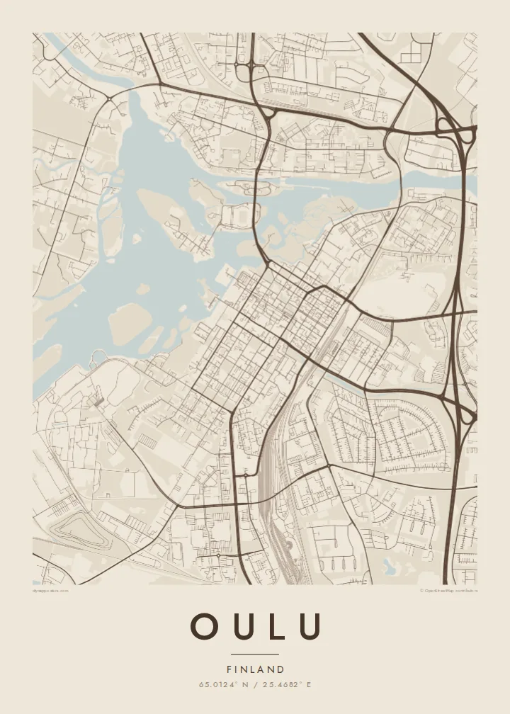
Near the sea the river divides into several channels, creating a fan of islands, footbridges and green spaces that gives the centre of the poster its most intricate detail.
Qeeqabak kaartah poster · Finland
65.0124° N / 25.4682° E
River channels and islands fanning out into the Gulf of Bothnia, with a neat grid of blocks on the southern bank.


Inki magaala, konoy gaba
Qande inkih tibbixeeh derre baguley table. Kulli qande missoowa caagid—daabbisimta, dirbaabu-le kaadu HD fayla akah.
 Cagalah pixels · 24 × 36″ daabbi fayla
Maxxaacah qeeqa
Tama usuk cagalah daabbi faylak 100% qambaala. Kulli poster — daabbisimta, dirbaabu-le kaadu download geytimta — ni-server-ittal 300 DPI-l ederimta, 7,200 × 10,800 pixels fanah, tokkel iyyi ellee catoy 24 × 36″ daabbi baxsi bahisak raaqu.
Gidarih


Kaarta
Oulu stands where the Oulu River reaches the Gulf of Bothnia in northern Finland. On a map the river splits into several channels near the sea, leaving a cluster of islands and parkland between the city centre and the harbour. The centre itself follows a regular grid of rectangular blocks, a legacy of Nordic town planning, while newer districts spread along the coast and inland over flat, forested ground.
Founded in the early seventeenth century as a trading town, Oulu later grew on tar, timber and shipping. In recent decades it became known for technology and research, with a large university and a long connection to mobile telecommunications. The city was named a European Capital of Culture for 2026. Its market square by the water, with the small bronze policeman statue, remains a familiar meeting point.
An Oulu map poster turns the delta into a delicate study of water and land. Islands such as Hupisaaret appear as small shapes surrounded by channels, bridges tie them back to the grid, and the coastline breaks into bays and peninsulas further north. In winter the sea freezes over, and the drawn shoreline becomes the only clear sign of where the land ends.
Near the sea the river divides into several channels, creating a fan of islands, footbridges and green spaces that gives the centre of the poster its most intricate detail.
The old centre is laid out in straight, even blocks south of the river, a crisp pattern that contrasts neatly with the irregular water shapes around it.
To the west the city meets the Gulf of Bothnia in a broken line of bays, harbours and small peninsulas, drawn in pale outline against open water.
Kok tanim ab
Ayro, migaq hinnay kok tan xagar osis; gaba, ballaqa hinnay xiqa soorris.
Free preview qansarissi kee watermark-le. Daabbisimtaan kee HD fayla 300 DPI-l, 7,200 × 10,800 px fanah, watermark maleh ederimta.
Macah Oulu
Oulu is hung by students and researchers who spent formative years there, by families from North Ostrobothnia and by visitors who came for the Capital of Culture year. The delta and the grid make a calm, balanced print.
Personalise the title, subtitle and coordinates line, for example with a graduation year or a home district, and choose one of five styles: Classic black & white, Noir, Paper, Blueprint or Sand. Blueprint suits the watery delta particularly well.
Oulu poster orme| Maxxaacah ballaqa | Qeeqa | Faylal |
|---|---|---|
| 30 × 40 cm (11.8 × 15.7″) | 3,543 × 4,724 px | PNG · PDF |
| 29.7 × 42 cm (A3, 11.7 × 16.5″) | 3,508 × 4,961 px | PNG · PDF |
| 42 × 59.4 cm (A2, 16.5 × 23.4″) | 4,961 × 7,016 px | PNG · PDF |
| 45.7 × 61 cm (18 × 24″) | 5,400 × 7,200 px | PNG · PDF |
| 50 × 70 cm (19.7 × 27.6″) | 5,906 × 8,268 px | PNG · PDF |
| 61 × 91.4 cm (24 × 36″) | 7,200 × 10,800 px | PNG · PDF |
Tabbaltah, limo-wayta xaqqa-le ablo 900 px ballaqa le, asta le, iskiriinih keh tan. HD faylal gexsoh inkih addal 8× fanah qeeqa le, poster ballaqa inkih addal meqeh maxxaacimta.
Baxxaqqa qari le qandiy dooriy, tohuk lakal Daabbisimtah Poster — kutuk kee, faxximek, dirbaabu — hinnay HD Digital Fayla dooru. Checkout inki wagitti geytima, kaadu ku-orme page keenih adissa akke waqdi caagoy kummite.
Usuk 200 gsm-le catam kutuk warqatal, lica katiy caagitte {printFrom}-ik hane ayta 30 × 40 cm-ik 24 × 36″ fanah, xaagu keenil warreeh.
Ee. Sarrah-le dirbaabu doori — bad, gudduc, oak-le hinnay bad-madabuy. Usuk finqisiimam ellee sange qarab-le kaadu qari umukku iyya keenih taagu. Dirbaabu-le poster {framedFrom}-ik hane, xaagu keenil warreeh.
Xaagu addunyal inkih cisab-le. Kulli poster 30+ ummattak ni-daabbi-mara mananih xayyoysa kaadu 3–7 caagu-ayróh fanah geeytima. Ku-orme kee xaagu tarikiy My Orders addal ablitta.
Geytimeek 14 ayróy addal foto naah rubbaay, cisab-le daabbisiynah hinnay ku-lacay gacisnaah.
Ee. Tama page-l edito addal, migaaq, subtitle kee coordinates sarrah faxxem fanah badal, kaadu qande kee katiy doori. Daabbisimtah, dirbaabu-le kaadu digital orme inkih ku-design cagalah yekkelen.
$9 bacisak 300 DPI PNG kee daabbisimtah adissime PDF fayla lica katiy inkih, watermark maleh, ayyi meki daabbisimtah geeytitta. Cisab makkoysemty ana? Awqak, watermark-le free preview download-eh.
