Osor swing bridge
At the island's northern end, a narrow canal separates Lošinj from Cres. A small swing bridge crosses it and opens for passing boats. On the map it is a tiny break in one long line of land.
Qeeqabak kaartah poster · Croatia
44.5933° N / 14.4402° E
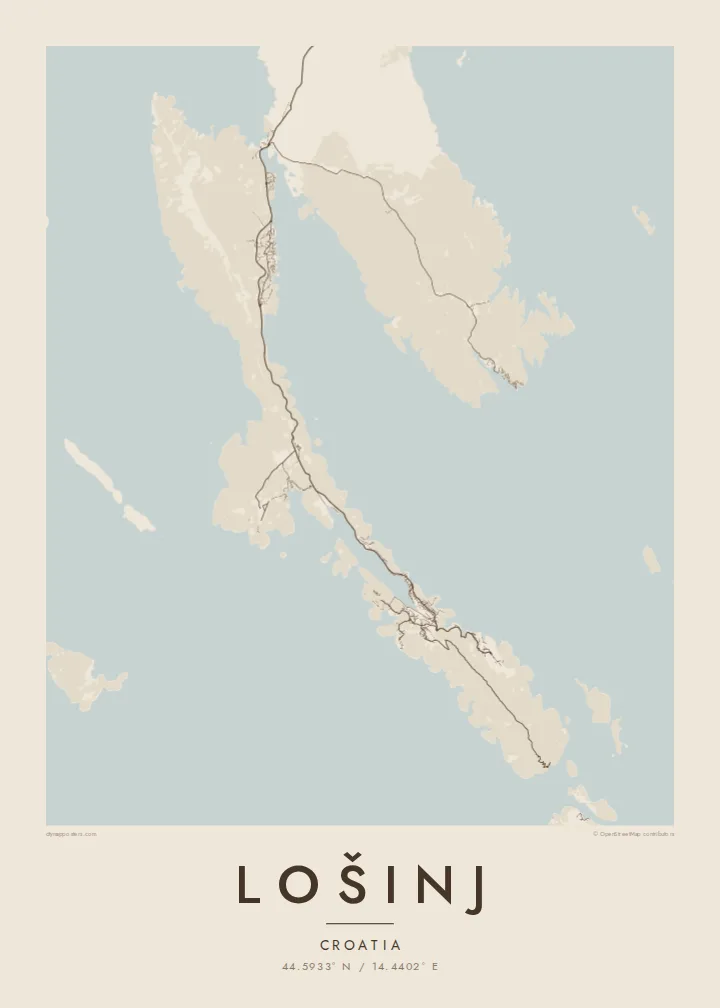
A long, thin island of the Kvarner Gulf, cut by deep bays and linked to Cres by a swing bridge.


Inki magaala, konoy gaba
Qande inkih tibbixeeh derre baguley table. Kulli qande missoowa caagid—daabbisimta, dirbaabu-le kaadu HD fayla akah.
 Cagalah pixels · 24 × 36″ daabbi fayla
Maxxaacah qeeqa
Tama usuk cagalah daabbi faylak 100% qambaala. Kulli poster — daabbisimta, dirbaabu-le kaadu download geytimta — ni-server-ittal 300 DPI-l ederimta, 7,200 × 10,800 pixels fanah, tokkel iyyi ellee catoy 24 × 36″ daabbi baxsi bahisak raaqu.
Gidarih


Kaarta
Lošinj lies in the Kvarner Gulf off Croatia, a narrow island running roughly north to south. Only a short canal at Osor separates it from Cres. From above it is remarkably thin, with long pine-covered peninsulas and bays so deep that in places only a strip of land remains. The main road runs the length of the island, from the bridge in the north to the villages in the south.
Mali Lošinj, the main town and one of the largest settlements on any Croatian island, wraps around the end of a long, sheltered bay. Its streets climb the slopes around the harbour. On the nearby Čikat peninsula, pine woods were planted in the nineteenth century, when the town became a health resort. A Lošinj map poster makes this inner harbour the natural centre of the composition.
Veli Lošinj, just to the southeast, is a smaller town around a narrow cove and was once home to many sea captains. In 1999 a Greek bronze statue of an athlete, the Apoxyomenos, was raised from the sea nearby, and it now has its own museum in Mali Lošinj. The surrounding waters are also studied for their resident bottlenose dolphins.
At the island's northern end, a narrow canal separates Lošinj from Cres. A small swing bridge crosses it and opens for passing boats. On the map it is a tiny break in one long line of land.
A long, protected bay reaching deep into the island, with the town at its head. It is the densest cluster of streets and the most recognisable shape on the island.
West of Mali Lošinj, a wooded peninsula with coves, promenades and beaches, shaped by the island's past as a health resort. Its coastline adds soft curves beside the town.
Kok tanim ab
Ayro, migaq hinnay kok tan xagar osis; gaba, ballaqa hinnay xiqa soorris.
Free preview qansarissi kee watermark-le. Daabbisimtaan kee HD fayla 300 DPI-l, 7,200 × 10,800 px fanah, watermark maleh ederimta.
Macah Lošinj
Lošinj draws sailors, families on long summer stays, and people who come for the air and the pines, as visitors have since the nineteenth century. Its slender outline suits a tall frame and looks strikingly delicate in print.
Edit the title, subtitle and coordinates line to name a marina, a family house or a year. Choose Classic black & white, Noir, Paper, Blueprint or Sand. The $9 download includes 300 DPI PNGs and print-ready PDFs, and printed posters ship from partners in 30+ countries.
Lošinj poster orme| Maxxaacah ballaqa | Qeeqa | Faylal |
|---|---|---|
| 30 × 40 cm (11.8 × 15.7″) | 3,543 × 4,724 px | PNG · PDF |
| 29.7 × 42 cm (A3, 11.7 × 16.5″) | 3,508 × 4,961 px | PNG · PDF |
| 42 × 59.4 cm (A2, 16.5 × 23.4″) | 4,961 × 7,016 px | PNG · PDF |
| 45.7 × 61 cm (18 × 24″) | 5,400 × 7,200 px | PNG · PDF |
| 50 × 70 cm (19.7 × 27.6″) | 5,906 × 8,268 px | PNG · PDF |
| 61 × 91.4 cm (24 × 36″) | 7,200 × 10,800 px | PNG · PDF |
Tabbaltah, limo-wayta xaqqa-le ablo 900 px ballaqa le, asta le, iskiriinih keh tan. HD faylal gexsoh inkih addal 8× fanah qeeqa le, poster ballaqa inkih addal meqeh maxxaacimta.
Baxxaqqa qari le qandiy dooriy, tohuk lakal Daabbisimtah Poster — kutuk kee, faxximek, dirbaabu — hinnay HD Digital Fayla dooru. Checkout inki wagitti geytima, kaadu ku-orme page keenih adissa akke waqdi caagoy kummite.
Usuk 200 gsm-le catam kutuk warqatal, lica katiy caagitte $39-ik hane ayta 30 × 40 cm-ik 24 × 36″ fanah, xaagu keenil warreeh.
Ee. Sarrah-le dirbaabu doori — bad, gudduc, oak-le hinnay bad-madabuy. Usuk finqisiimam ellee sange qarab-le kaadu qari umukku iyya keenih taagu. Dirbaabu-le poster $99-ik hane, xaagu keenil warreeh.
Shipping is free worldwide. Each poster is printed by the nearest of our print partners in 30+ countries and usually arrives in 3–7 business days. You can follow the status and tracking under My Orders. A few countries take 2–5 weeks, and where we don't ship yet, the site tells you before you pay.
Geytimeek 14 ayróy addal foto naah rubbaay, cisab-le daabbisiynah hinnay ku-lacay gacisnaah.
Ee. Tama page-l edito addal, migaaq, subtitle kee coordinates sarrah faxxem fanah badal, kaadu qande kee katiy doori. Daabbisimtah, dirbaabu-le kaadu digital orme inkih ku-design cagalah yekkelen.
$9 bacisak 300 DPI PNG kee daabbisimtah adissime PDF fayla lica katiy inkih, watermark maleh, ayyi meki daabbisimtah geeytitta. Cisab makkoysemty ana? Awqak, watermark-le free preview download-eh.
Xayyo
