The caldera
The flooded centre of the old volcano forms a broad open space inside the crescent. It is bordered by cliffs that fall steeply into the sea.
Qeeqabak kaartah poster · Greece
36.4072° N / 25.4209° E
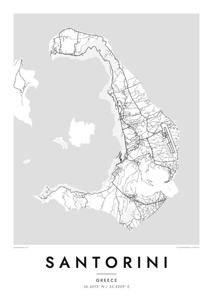
A crescent of land around a flooded volcanic caldera, with a young volcanic island rising in the middle.


Inki magaala, konoy gaba
Qande inkih tibbixeeh derre baguley table. Kulli qande missoowa caagid—daabbisimta, dirbaabu-le kaadu HD fayla akah.
 Cagalah pixels · 24 × 36″ daabbi fayla
Maxxaacah qeeqa
Tama usuk cagalah daabbi faylak 100% qambaala. Kulli poster — daabbisimta, dirbaabu-le kaadu download geytimta — ni-server-ittal 300 DPI-l ederimta, 7,200 × 10,800 pixels fanah, tokkel iyyi ellee catoy 24 × 36″ daabbi baxsi bahisak raaqu.
Gidarih


Kaarta
Santorini is the remaining rim of a volcano. From above, the main island forms a crescent that wraps around a large, flooded caldera, with Therasia and a smaller islet completing the ring to the west. In the centre of the water sits Nea Kameni, a dark, young volcanic island that formed in eruptions over the past few centuries.
The inner edge of the crescent is a steep cliff, and the island's best-known villages cling to its top. Fira, the main town, and Oia at the northern tip are dense clusters of lanes and stairways overlooking the caldera. The outer side slopes gently to the east and south, towards farmland, vineyards and long dark beaches. The airport and most of the roads are on this side.
A Santorini map poster captures one of the most dramatic outlines in the Mediterranean. The Bronze Age eruption that shaped much of the caldera buried the settlement at Akrotiri, on the southern tip, and preserved its buildings and wall paintings under ash. On the map, the curve of the island and the empty water inside it make a striking composition in black and white.
The flooded centre of the old volcano forms a broad open space inside the crescent. It is bordered by cliffs that fall steeply into the sea.
A young volcanic island in the middle of the caldera, formed by eruptions over recent centuries. It appears as a dark, compact shape in the empty water.
Tight networks of lanes and steps run along the rim of the cliff. From above they look like fine lines tracing the inner edge of the island.
Kok tanim ab
Ayro, migaq hinnay kok tan xagar osis; gaba, ballaqa hinnay xiqa soorris.
Free preview qansarissi kee watermark-le. Daabbisimtaan kee HD fayla 300 DPI-l, 7,200 × 10,800 px fanah, watermark maleh ederimta.
Macah Santorini
Santorini is where many people get married, spend a honeymoon or watch a sunset they still talk about. The crescent and caldera make an image that is instantly recognisable, and a monochrome print keeps it graphic rather than postcard-like.
Add names and a date to the title and subtitle, or set the coordinates to a particular terrace in Oia or Fira. Choose from Classic black & white, Noir, Paper, Blueprint or Sand.
Santorini poster orme| Maxxaacah ballaqa | Qeeqa | Faylal |
|---|---|---|
| 30 × 40 cm11.8 × 15.7″ | 3,543 × 4,724 px | PNG · PDF |
| 29.7 × 42 cm (A3)11.7 × 16.5″ | 3,508 × 4,961 px | PNG · PDF |
| 42 × 59.4 cm (A2)16.5 × 23.4″ | 4,961 × 7,016 px | PNG · PDF |
| 45.7 × 61 cm18 × 24″ | 5,400 × 7,200 px | PNG · PDF |
| 50 × 70 cm19.7 × 27.6″ | 5,906 × 8,268 px | PNG · PDF |
| 61 × 91.4 cm24 × 36″ | 7,200 × 10,800 px | PNG · PDF |
Tabbaltah, limo-wayta xaqqa-le ablo 900 px ballaqa le, asta le, iskiriinih keh tan. HD faylal gexsoh inkih addal 8× fanah qeeqa le, poster ballaqa inkih addal meqeh maxxaacimta.
Baxxaqqa qari le qandiy dooriy, tohuk lakal Daabbisimtah Poster — kutuk kee, faxximek, dirbaabu — hinnay HD Digital Fayla dooru. Checkout inki wagitti geytima, kaadu ku-orme page keenih adissa akke waqdi caagoy kummite.
Usuk 200 gsm-le catam kutuk warqatal, lica katiy caagitte $39-ik hane ayta 30 × 40 cm-ik 24 × 36″ fanah, xaagu keenil warreeh.
Ee. Sarrah-le dirbaabu doori — bad, gudduc, oak-le hinnay bad-madabuy. Usuk finqisiimam ellee sange qarab-le kaadu qari umukku iyya keenih taagu. Dirbaabu-le poster $99-ik hane, xaagu keenil warreeh.
Dirsa 60+ baaxoh bilsa. Poster kasa 30+ baaxoh nel print kaadu yan kee dirgeh kaxxa kee tanah printa, kee 3–7 xaqu ayyaamah yaaxigeeh. Xaaloo kee tracking "Ac Order" gexsitam. Kaadu baaxo 2–5 isbuuc yaaxigeeh, nanu dirsi yanin baaxoh sajiitah site ku kalah tekkeh.
Geytimeek 14 ayróy addal foto naah rubbaay, cisab-le daabbisiynah hinnay ku-lacay gacisnaah.
Ee. Tama page-l edito addal, migaaq, subtitle kee coordinates sarrah faxxem fanah badal, kaadu qande kee katiy doori. Daabbisimtah, dirbaabu-le kaadu digital orme inkih ku-design cagalah yekkelen.
$9 bacisak 300 DPI PNG kee daabbisimtah adissime PDF fayla lica katiy inkih, watermark maleh, ayyi meki daabbisimtah geeytitta. Cisab makkoysemty ana? Awqak, watermark-le free preview download-eh.
Xayyo
