Interstate junction
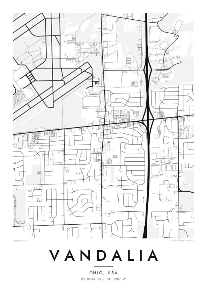
I-70 and I-75 meet near Vandalia, and the interchange loops show up clearly from above. They frame the city with the widest and boldest lines on the print.
Qeeqabak kaartah poster · United States
39.8906° N / 84.1988° W
An Ohio crossroads city north of Dayton, where interstates, the National Road and airport runways meet in a suburban grid


Inki magaala, konoy gaba
Qande inkih tibbixeeh derre baguley table. Kulli qande missoowa caagid—daabbisimta, dirbaabu-le kaadu HD fayla akah.
 Cagalah pixels · 24 × 36″ daabbi fayla
Maxxaacah qeeqa
Tama usuk cagalah daabbi faylak 100% qambaala. Kulli poster — daabbisimta, dirbaabu-le kaadu download geytimta — ni-server-ittal 300 DPI-l ederimta, 7,200 × 10,800 pixels fanah, tokkel iyyi ellee catoy 24 × 36″ daabbi baxsi bahisak raaqu.
Gidarih


Kaarta
Vandalia lies just north of Dayton, Ohio, at a point where major routes come together. Interstate 75 runs north–south along its eastern side, Interstate 70 runs east–west through the area, and the historic National Road, now US 40, passes through the city. The local slogan, Crossroads of America, describes the map quite literally.
Dayton International Airport sits immediately to the west, and its runways form long, crossing lines at the edge of the city. Between the highways, Vandalia's residential streets follow a mostly regular grid with some curving subdivisions. Parks, schools and a compact centre along the old National Road break it up. Farmland still reaches the outer edges.
A Vandalia map poster shows a place defined by movement: interchanges, arterial roads and runways surrounding a quiet, ordinary suburb. In black and white, the heavy highway lines, the fine residential streets and the geometric airfield make one of the more graphic compositions among small Ohio cities.
I-70 and I-75 meet near Vandalia, and the interchange loops show up clearly from above. They frame the city with the widest and boldest lines on the print.
US 40, the historic National Road, runs through Vandalia. It was one of the first major federally built roads in the United States and still forms a central axis of the city.
Dayton International Airport lies just west of the city. Its runways and taxiways create a large geometric shape at the edge of the map.
Kok tanim ab
Ayro, migaq hinnay kok tan xagar osis; gaba, ballaqa hinnay xiqa soorris.
Free preview qansarissi kee watermark-le. Daabbisimtaan kee HD fayla 300 DPI-l, 7,200 × 10,800 px fanah, watermark maleh ederimta.
Macah Vandalia
A map of Vandalia suits people from the Dayton area, aviation enthusiasts and anyone whose life has passed through this crossroads. It shows a familiar place with more structure and character than people usually expect.
Title it with your street, family or high school class, add a date, and keep the coordinates. Choose from Classic black & white, Noir, Paper, Blueprint or Sand. Order it printed on matte paper, with or without a wooden frame.
Vandalia poster orme| Maxxaacah ballaqa | Qeeqa | Faylal |
|---|---|---|
| 30 × 40 cm11.8 × 15.7″ | 3,543 × 4,724 px | PNG · PDF |
| 29.7 × 42 cm (A3)11.7 × 16.5″ | 3,508 × 4,961 px | PNG · PDF |
| 42 × 59.4 cm (A2)16.5 × 23.4″ | 4,961 × 7,016 px | PNG · PDF |
| 45.7 × 61 cm18 × 24″ | 5,400 × 7,200 px | PNG · PDF |
| 50 × 70 cm19.7 × 27.6″ | 5,906 × 8,268 px | PNG · PDF |
| 61 × 91.4 cm24 × 36″ | 7,200 × 10,800 px | PNG · PDF |
Tabbaltah, limo-wayta xaqqa-le ablo 900 px ballaqa le, asta le, iskiriinih keh tan. HD faylal gexsoh inkih addal 8× fanah qeeqa le, poster ballaqa inkih addal meqeh maxxaacimta.
Baxxaqqa qari le qandiy dooriy, tohuk lakal Daabbisimtah Poster — kutuk kee, faxximek, dirbaabu — hinnay HD Digital Fayla dooru. Checkout inki wagitti geytima, kaadu ku-orme page keenih adissa akke waqdi caagoy kummite.
Usuk 200 gsm-le catam kutuk warqatal, lica katiy caagitte $39-ik hane ayta 30 × 40 cm-ik 24 × 36″ fanah, xaagu keenil warreeh.
Ee. Sarrah-le dirbaabu doori — bad, gudduc, oak-le hinnay bad-madabuy. Usuk finqisiimam ellee sange qarab-le kaadu qari umukku iyya keenih taagu. Dirbaabu-le poster $99-ik hane, xaagu keenil warreeh.
Dirsa 60+ baaxoh bilsa. Poster kasa 30+ baaxoh nel print kaadu yan kee dirgeh kaxxa kee tanah printa, kee 3–7 xaqu ayyaamah yaaxigeeh. Xaaloo kee tracking "Ac Order" gexsitam. Kaadu baaxo 2–5 isbuuc yaaxigeeh, nanu dirsi yanin baaxoh sajiitah site ku kalah tekkeh.
Geytimeek 14 ayróy addal foto naah rubbaay, cisab-le daabbisiynah hinnay ku-lacay gacisnaah.
Ee. Tama page-l edito addal, migaaq, subtitle kee coordinates sarrah faxxem fanah badal, kaadu qande kee katiy doori. Daabbisimtah, dirbaabu-le kaadu digital orme inkih ku-design cagalah yekkelen.
$9 bacisak 300 DPI PNG kee daabbisimtah adissime PDF fayla lica katiy inkih, watermark maleh, ayyi meki daabbisimtah geeytitta. Cisab makkoysemty ana? Awqak, watermark-le free preview download-eh.
