Patuxent River edge
The river runs along the northern side of the old town, where the mill once stood, drawing a soft natural line against the regular streets.
মিনিমালিস্ট ম্যাপ পোস্টার · মার্কিন যুক্তরাষ্ট্র
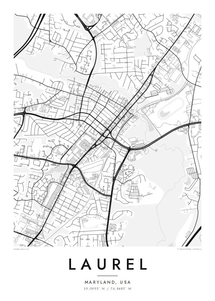
39.0993° N / 76.8483° W
A former mill town on the Patuxent River, set between Baltimore and Washington along old and new corridors.


এক শহর, পাঁচ মেজাজ
একটি স্টাইলে ট্যাপ করে দেয়ালে দেখুন। প্রতিটি স্টাইলের দাম একই — প্রিন্ট, ফ্রেমসহ বা HD ফাইল হিসেবে।
 প্রকৃত পিক্সেল · 24 × 36″ প্রিন্ট ফাইল
প্রিন্টে ঝকঝকে
এটি আসল প্রিন্ট ফাইলের ১০০% ক্রপ। প্রতিটি পোস্টার — প্রিন্ট করা, ফ্রেমসহ বা ডাউনলোড করা — আমাদের সার্ভারে 300 DPI-তে, 7,200 × 10,800 পিক্সেল পর্যন্ত রেন্ডার করা হয়, তাই 24 × 36″ প্রিন্টেও সবচেয়ে ছোট গলিটাও স্পষ্ট থাকে।
দেয়ালে


ম্যাপ
Laurel sits on the Patuxent River in Maryland, roughly midway between Baltimore and Washington. The city grew in the nineteenth century around a cotton mill powered by the river, and its historic Main Street still runs down toward the water. On a map, the river forms a clear boundary to the north, with the older grid of the centre sitting just above later suburban growth.
Route 1 and the railway line connect Laurel to both larger cities, and the city has expanded along those routes. Laurel Park, a thoroughbred racetrack, lies near the town, and the Patuxent Research Refuge, a large area of protected forest and wetland, occupies land to the east, adding broad natural areas to the regional map.
A Laurel map poster shows that mix of older and newer layers: the compact Main Street grid, the curve of the Patuxent, the straight rail line and the suburban streets that grew around them. It is a composition with clear structure, well suited to a minimalist print.
The river runs along the northern side of the old town, where the mill once stood, drawing a soft natural line against the regular streets.
Historic Main Street and the railway line form the backbone of the centre, linking the city's mill-town origins with its role as a commuter town.
The Patuxent Research Refuge and nearby parkland create large calm areas on the map, contrasting with the dense neighbourhoods around the centre.
নিজের মতো করে নিন
একটি তারিখ, নাম বা নিজের কোনো লাইন যোগ করুন, স্টাইল, সাইজ বা ওরিয়েন্টেশন বদলান।
ফ্রি প্রিভিউ কম রেজোলিউশনের ও ওয়াটারমার্কযুক্ত। প্রিন্ট ও HD ফাইল 300 DPI-তে, 7,200 × 10,800 px পর্যন্ত, ওয়াটারমার্ক ছাড়া রেন্ডার করা হয়।
কেন Laurel
Laurel suits people who have lived between Baltimore and Washington and found a home here, or who remember Main Street from childhood. The map records a real sense of place in a region often seen only from the highway.
Personalise the title, subtitle and coordinates line with a date or a name, and choose from five styles. Paper suits the mill-town history, while Noir gives the river and rail lines a strong graphic contrast.
Laurel পোস্টার অর্ডার করুন| প্রিন্ট সাইজ | রেজোলিউশন | ফাইল |
|---|---|---|
| 30 × 40 cm11.8 × 15.7″ | 3,543 × 4,724 px | PNG · PDF |
| 29.7 × 42 cm (A3)11.7 × 16.5″ | 3,508 × 4,961 px | PNG · PDF |
| 42 × 59.4 cm (A2)16.5 × 23.4″ | 4,961 × 7,016 px | PNG · PDF |
| 45.7 × 61 cm18 × 24″ | 5,400 × 7,200 px | PNG · PDF |
| 50 × 70 cm19.7 × 27.6″ | 5,906 × 8,268 px | PNG · PDF |
| 61 × 91.4 cm24 × 36″ | 7,200 × 10,800 px | PNG · PDF |
তুলনার জন্য, ফ্রি প্রিভিউটি 900 px চওড়া, ওয়াটারমার্কসহ এবং স্ক্রিনে দেখার জন্য তৈরি। HD ফাইলগুলোর রেজোলিউশন প্রতিটি দিকে সর্বোচ্চ ৮ গুণ বেশি এবং পূর্ণ পোস্টার সাইজে পরিষ্কার প্রিন্ট হয়।
পেজের উপরে একটি স্টাইল বেছে নিন, তারপর প্রিন্টেড পোস্টার — একটি সাইজ ও, চাইলে, একটি ফ্রেম — অথবা ডিজিটাল HD ফাইল বেছে নিন। চেকআউট মাত্র এক ধাপে হয়, আর পেমেন্ট সম্পন্ন হওয়া মাত্রই আপনার অর্ডার পেজ আপডেট হয়ে যায়।
এটি প্রিমিয়াম 200 gsm ম্যাট পেপারে ছয়টি সাইজের যেকোনো একটিতে প্রিন্ট করা হয়, 30 × 40 সেমি থেকে 24 × 36″ পর্যন্ত। প্রিন্টেড পোস্টার শুরু হয় $39 থেকে, শিপিং সহ।
হ্যাঁ। কালো, সাদা, ন্যাচারাল ওক বা ডার্ক উডের সলিড কাঠের ফ্রেম বেছে নিন। এতে রয়েছে শ্যাটারপ্রুফ গ্লেজিং এবং এটি দেয়ালে টাঙানোর জন্য প্রস্তুত থাকে। ফ্রেমসহ পোস্টার শুরু হয় $99 থেকে, শিপিং সহ।
৬০+ দেশে শিপিং বিনামূল্যে। প্রতিটি পোস্টার ৩০+ দেশে থাকা আমাদের প্রিন্ট পার্টনারদের মধ্যে সবচেয়ে কাছের জন প্রিন্ট করে এবং সাধারণত ৩–৭ কার্যদিবসে পৌঁছে যায়। স্ট্যাটাস ও ট্র্যাকিং দেখতে পারবেন "আমার অর্ডার" পেজে। কিছু দেশে ২–৫ সপ্তাহ লাগে, আর যেসব দেশে আমরা এখনও শিপ করি না, পেমেন্টের আগেই সাইট আপনাকে জানিয়ে দেবে।
ডেলিভারির 14 দিনের মধ্যে আমাদের একটি ছবি পাঠান, আমরা বিনামূল্যে আবার প্রিন্ট করে দেব বা রিফান্ড করব।
হ্যাঁ। এই পেজের এডিটরে টাইটেল, সাবটাইটেল ও কোঅর্ডিনেট লাইন আপনার ইচ্ছেমতো বদলে নিন, আর একটি স্টাইল ও সাইজ বেছে নিন। প্রিন্টেড, ফ্রেমসহ ও ডিজিটাল — সব অর্ডারই ঠিক আপনার ডিজাইন অনুযায়ী তৈরি হয়।
$9-এ আপনি পাবেন 300 DPI PNG ও প্রিন্ট-রেডি PDF ফাইল, সবগুলো ছয়টি সাইজে, ওয়াটারমার্ক ছাড়া, যেকোনো জায়গায় প্রিন্ট করার জন্য। এখনো নিশ্চিত নন? আগে একটি ফ্রি ওয়াটারমার্কযুক্ত প্রিভিউ ডাউনলোড করে দেখুন।
কাছাকাছি
