Downtown grid
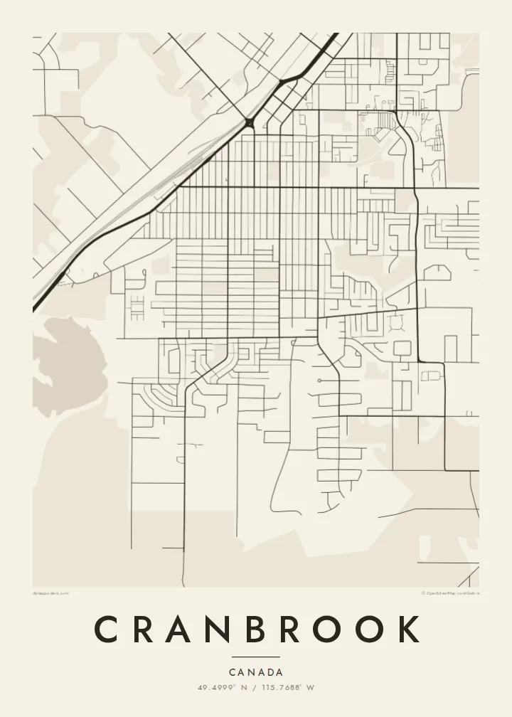
The original blocks form a tidy rectangular pattern next to the railway, a legible core surrounded by more loosely planned suburbs.
Póster de mapa minimalista · Canadá
49.4999° N / 115.7688° W
A railway town in the Rocky Mountain Trench, a street grid laid out on a wide valley floor between two mountain ranges




Una ciudad, cinco ambientes
Toca un estilo para verlo en la pared. Todos los estilos cuestan lo mismo: impreso, enmarcado o en archivos HD.
 Píxeles reales · archivo de impresión de 24 × 36″
Nitidez de impresión
Este es un recorte al 100% del archivo de impresión real. Cada póster —impreso, enmarcado o descargado— se renderiza en nuestros servidores a 300 DPI, hasta 7,200 × 10,800 píxeles, para que hasta las calles más pequeñas se vean nítidas en una impresión de 24 × 36″.
En la pared


El mapa
Cranbrook is the largest city of the East Kootenay in south-eastern British Columbia, set on the broad floor of the Rocky Mountain Trench. The Rockies rise to the east and the Purcells to the west. From above, the city is a clear grid of streets laid out on open, gently sloping land, with the mountains beyond the edge of the frame.
The Canadian Pacific rail line runs through the town, and the downtown grid lines up with it. Highways 3 and 95 join here and bring a commercial strip along their route, while newer suburbs curve away from the older blocks. Small lakes and wooded parks lie on the outskirts.
Cranbrook grew as a railway town, and the Cranbrook History Centre keeps a notable collection of restored heritage rail cars. A Cranbrook map poster shows the rail line, the downtown grid and the highway corridor, the network that explains how the town took its shape in the valley.
The original blocks form a tidy rectangular pattern next to the railway, a legible core surrounded by more loosely planned suburbs.
The rail line crosses the city in a long, steady stroke, a reminder that Cranbrook was established as a railway town.
Highways 3 and 95 meet in town, and their routes add strong diagonal and curving lines to the grid.
Hazlo tuyo
Añade una fecha, un nombre o una frase propia, y cambia el estilo, el tamaño o la orientación.
La vista previa gratuita es de baja resolución y con marca de agua. Las impresiones y los archivos HD se renderizan a 300 DPI, hasta 7,200 × 10,800 px, sin marca de agua.
Por qué Cranbrook
Cranbrook suits people from the Kootenays, those who come for the mountains around it, and anyone who has worked on the railway. The grid and the rail line make a crisp, orderly print.
You can change the title, subtitle and coordinates line to suit the occasion. Blueprint echoes the railway theme, and Classic black & white, Noir, Paper and Sand are also available.
Pedir el póster Cranbrook| Tamaño de impresión | Resolución | Archivos |
|---|---|---|
| 30 × 40 cm (11.8 × 15.7″) | 3,543 × 4,724 px | PNG · PDF |
| 29.7 × 42 cm (A3, 11.7 × 16.5″) | 3,508 × 4,961 px | PNG · PDF |
| 42 × 59.4 cm (A2, 16.5 × 23.4″) | 4,961 × 7,016 px | PNG · PDF |
| 45.7 × 61 cm (18 × 24″) | 5,400 × 7,200 px | PNG · PDF |
| 50 × 70 cm (19.7 × 27.6″) | 5,906 × 8,268 px | PNG · PDF |
| 61 × 91.4 cm (24 × 36″) | 7,200 × 10,800 px | PNG · PDF |
Como referencia, la vista previa gratuita mide 900 px de ancho, lleva marca de agua y está pensada para pantallas. Los archivos HD tienen hasta 8 veces más resolución en cada dirección y se imprimen con total nitidez a tamaño póster.
Elige un estilo arriba de la página y luego selecciona Póster Impreso —un tamaño y, si quieres, un marco— o Archivos Digitales HD. El pago se hace en un solo paso, y tu página de pedido se actualiza en cuanto se confirma el pago.
Se imprime en papel mate premium de 200 g/m² en uno de seis tamaños, desde 30 × 40 cm hasta 24 × 36″. Los pósters impresos cuestan desde {printFrom}, envío incluido.
Sí. Elige un marco de madera maciza en negro, blanco, roble natural o madera oscura. Incluye vidrio irrompible y llega listo para colgar. Los pósters enmarcados cuestan desde {framedFrom}, envío incluido.
El envío es gratis en todo el mundo. Cada póster lo imprime el socio de impresión más cercano entre más de 30 países y suele llegar en 3 a 7 días hábiles. Puedes seguir el estado y el seguimiento en Mis Pedidos.
Envíanos una foto dentro de los 14 días posteriores a la entrega y te lo reimprimimos gratis o te devolvemos el dinero.
Sí. En el editor de esta página, cambia el título, el subtítulo y la línea de coordenadas por lo que quieras, y elige un estilo y un tamaño. Los pedidos impresos, enmarcados y digitales usan exactamente tu diseño.
Por $9 obtienes archivos PNG a 300 DPI y PDF listos para imprimir en los seis tamaños, sin marca de agua, para imprimir donde quieras. ¿Aún no estás seguro? Descarga primero una vista previa gratis con marca de agua.
