Compact centre
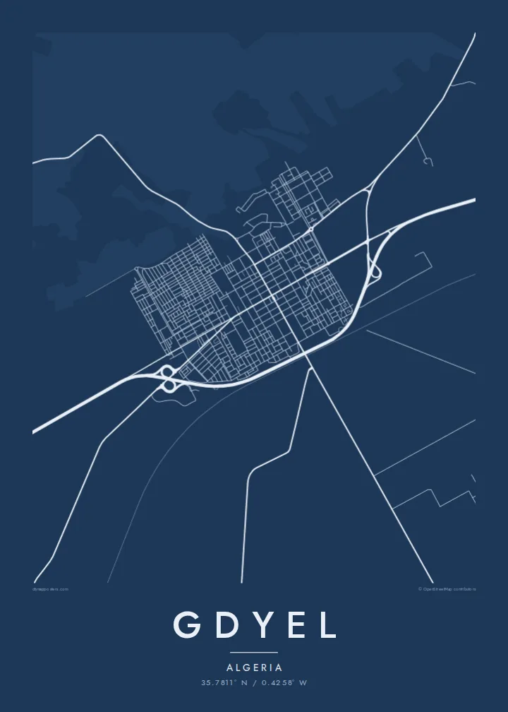
The older streets form a tight, fairly regular grid around a main road. It is the densest part of the sheet and easy to read at any print size.
Póster de mapa minimalista · Argelia
35.7811° N / 0.4258° W
A farming town on the plain east of Oran, its compact streets set among fields between the city and the coast.



Una ciudad, cinco ambientes
Toca un estilo para verlo en la pared. Todos los estilos cuestan lo mismo: impreso, enmarcado o en archivos HD.
 Píxeles reales · archivo de impresión de 24 × 36″
Nitidez de impresión
Este es un recorte al 100% del archivo de impresión real. Cada póster —impreso, enmarcado o descargado— se renderiza en nuestros servidores a 300 DPI, hasta 7,200 × 10,800 píxeles, para que hasta las calles más pequeñas se vean nítidas en una impresión de 24 × 36″.
En la pared


El mapa
Gdyel lies east of Oran in the coastal plain of western Algeria, in the band of farmland between the city and the Mediterranean shore around Arzew. On a map it forms a compact settlement. A regular street network sits around a central spine, and roads extend in straight lines across flat, cultivated land in every direction.
The town grew as an agricultural centre, and the surrounding fields are still what most people notice first on the map: large, geometric plots in which a few farm roads and irrigation lines are the only marks. Its closeness to Oran has also brought newer housing districts on the edges, and they appear as denser, more uniform blocks.
A Gdyel map poster works because of this simplicity. There is no dramatic coastline or winding river in the frame, just a clear town plan in a wide landscape, with the roads to Oran and the coast as its strongest lines. It is a quiet and honest portrait of a place that many people call home.
The older streets form a tight, fairly regular grid around a main road. It is the densest part of the sheet and easy to read at any print size.
Straight routes connect the town west to Oran and towards the coast, running across the plain as the longest and clearest lines on the poster.
Around the town, the land is divided into open field plots. They are drawn lightly, so the settlement appears as a sharp cluster within a calm space.
Hazlo tuyo
Añade una fecha, un nombre o una frase propia, y cambia el estilo, el tamaño o la orientación.
La vista previa gratuita es de baja resolución y con marca de agua. Las impresiones y los archivos HD se renderizan a 300 DPI, hasta 7,200 × 10,800 px, sin marca de agua.
Por qué Gdyel
A map of Gdyel is for people who know it from the inside: those raised there, those who moved to Oran or abroad, and those who return for the holidays. It keeps the shape of home in one frame.
Personalise the title, subtitle and coordinates line, in Latin or Arabic script. Choose from five styles, from Classic black & white to Paper, which gives the fields a soft background.
Pedir el póster Gdyel| Tamaño de impresión | Resolución | Archivos |
|---|---|---|
| 30 × 40 cm11.8 × 15.7″ | 3,543 × 4,724 px | PNG · PDF |
| 29.7 × 42 cm (A3)11.7 × 16.5″ | 3,508 × 4,961 px | PNG · PDF |
| 42 × 59.4 cm (A2)16.5 × 23.4″ | 4,961 × 7,016 px | PNG · PDF |
| 45.7 × 61 cm18 × 24″ | 5,400 × 7,200 px | PNG · PDF |
| 50 × 70 cm19.7 × 27.6″ | 5,906 × 8,268 px | PNG · PDF |
| 61 × 91.4 cm24 × 36″ | 7,200 × 10,800 px | PNG · PDF |
Como referencia, la vista previa gratuita mide 900 px de ancho, lleva marca de agua y está pensada para pantallas. Los archivos HD tienen hasta 8 veces más resolución en cada dirección y se imprimen con total nitidez a tamaño póster.
Elige un estilo arriba de la página y luego selecciona Póster Impreso —un tamaño y, si quieres, un marco— o Archivos Digitales HD. El pago se hace en un solo paso, y tu página de pedido se actualiza en cuanto se confirma el pago.
Se imprime en papel mate premium de 200 g/m² en uno de seis tamaños, desde 30 × 40 cm hasta 24 × 36″. Los pósters impresos cuestan desde $39, envío incluido.
Sí. Elige un marco de madera maciza en negro, blanco, roble natural o madera oscura. Incluye vidrio irrompible y llega listo para colgar. Los pósters enmarcados cuestan desde $99, envío incluido.
El envío es gratis a más de 60 países. Cada póster lo imprime el socio de impresión más cercano de nuestra red en más de 30 países y suele llegar en 3–7 días hábiles. Puedes seguir el estado y el seguimiento en Mis pedidos. Algunos países tardan de 2 a 5 semanas y, si aún no enviamos a tu país, la web te lo indica antes de pagar.
Envíanos una foto dentro de los 14 días posteriores a la entrega y te lo reimprimimos gratis o te devolvemos el dinero.
Sí. En el editor de esta página, cambia el título, el subtítulo y la línea de coordenadas por lo que quieras, y elige un estilo y un tamaño. Los pedidos impresos, enmarcados y digitales usan exactamente tu diseño.
Por $9 obtienes archivos PNG a 300 DPI y PDF listos para imprimir en los seis tamaños, sin marca de agua, para imprimir donde quieras. ¿Aún no estás seguro? Descarga primero una vista previa gratis con marca de agua.
