Al-Manara Square
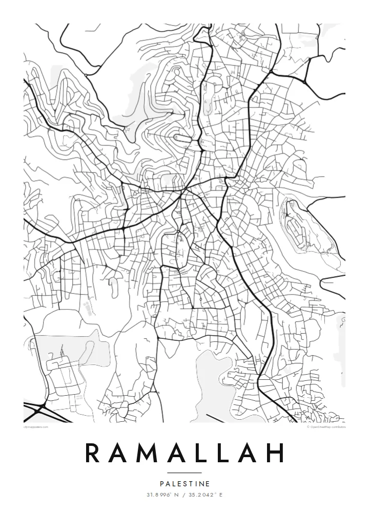
The central roundabout where major streets converge forms the heart of the map. The downtown pattern spreads out from this single point.
Postè kat minimalis · Palestinian Territories
31.8996° N / 35.2042° E
A hilltop city north of Jerusalem, with streets winding over ridges and descending into terraced valleys


Yon vil, senk atmosfè
Peze yon style pou wè li sou mi a. Chak style koute menm pri — enprime, ankadre oswa kòm fichye HD.
 Piksèl reyèl · fichye enpresyon 24 × 36″
Byen klè pou enprime
Sa a se yon zoom 100% sou vrè fichye enpresyon an. Chak afich — enprime, ankadre oswa telechaje — jenere sou sèvè nou yo nan 300 DPI, jiska 7,200 × 10,800 piksèl, konsa menm pi piti wout yo rete klè sou yon enpresyon 24 × 36″.
Sou mi a


Kat la
Ramallah sits high in the central hills of the West Bank, about 15 kilometres north of Jerusalem, at an elevation of around 800 metres or more. Its street plan is shaped by the terrain. Roads follow ridgelines and curve down into wadis, and many blocks are irregular because the ground rarely stays flat for long. Ramallah merges with the neighbouring city of al-Bireh, and the two form one continuous urban area.
At the centre is al-Manara Square, a roundabout where several main streets meet. It is the most recognisable point on the map. The city also serves as the administrative centre of the Palestinian Authority, and the Muqata'a compound includes the mausoleum of Yasser Arafat. Beyond the built-up edge, the map shows olive terraces and surrounding villages across the hills.
A Ramallah map poster shows a city defined by the land it stands on. Contour-following streets and scattered neighbourhoods on separate hills make it very different from a flat-plain city. For Palestinians at home and abroad, the map offers a way to hold a familiar place quietly and precisely.
The central roundabout where major streets converge forms the heart of the map. The downtown pattern spreads out from this single point.
Roads curve along ridges and drop into valleys, producing irregular blocks and flowing lines that clearly reflect the steep terrain beneath them.
Ramallah and al-Bireh run together without a visible break, forming one continuous urban area across several adjoining hills.
Fè l pou ou
Ajoute yon dat, yon non oswa pwòp fraz pa w, chanje estil, gwosè oswa oryantasyon.
Apèsi gratis la se nan rezolisyon ba avèk yon watèrmak. Enpresyon ak fichye HD yo jenere nan 300 DPI, jiska 7,200 × 10,800 px, san watèrmak.
Poukisa Ramallah
For many in the Palestinian diaspora, Ramallah is where family, work and memory meet. A precise, unadorned map lets the place speak for itself, without slogans or souvenir imagery. It suits a home, a studio or an office.
You can set the title in any form you prefer, add a neighbourhood or year in the subtitle, and keep or edit the coordinates. There are five styles to choose from. Sand and Paper suit the stone-coloured hills, and Noir brings out the winding streets most strongly.
Kòmande afich Ramallah a| Gwosè enpresyon | Rezolisyon | Fichye |
|---|---|---|
| 30 × 40 cm (11.8 × 15.7″) | 3,543 × 4,724 px | PNG · PDF |
| 29.7 × 42 cm (A3, 11.7 × 16.5″) | 3,508 × 4,961 px | PNG · PDF |
| 42 × 59.4 cm (A2, 16.5 × 23.4″) | 4,961 × 7,016 px | PNG · PDF |
| 45.7 × 61 cm (18 × 24″) | 5,400 × 7,200 px | PNG · PDF |
| 50 × 70 cm (19.7 × 27.6″) | 5,906 × 8,268 px | PNG · PDF |
| 61 × 91.4 cm (24 × 36″) | 7,200 × 10,800 px | PNG · PDF |
Pou konpare, apèsi gratis la gen 900 px lajè, li gen filigràn epi li fèt pou ekran. Fichye HD yo gen jiska 8 fwa plis rezolisyon nan chak direksyon epi yo enprime pwòp nan gwosè postè konplè.
Chwazi yon style anlè paj la, epi chwazi Afich Enprime — yon gwosè epi, si w vle, yon kad — oswa Fichye Dijital HD. Peman an fèt nan yon sèl etap, epi paj kòmand ou a mete ajou kou peman an konfime.
Li enprime sou papye mat premium 200 gsm nan youn nan sis gwosè, soti nan 30 × 40 cm rive nan 24 × 36″. Afich enprime yo kòmanse nan {printFrom}, livrezon enkli.
Wi. Chwazi yon kad an bwa solid nan koulè nwa, blan, chenn natirèl oswa bwa fonse. Li vin ak yon vit ki pa kase epi li pare pou pandye. Afich ankadre yo kòmanse nan {framedFrom}, livrezon enkli.
Livrezon an gratis nan tout mond lan. Se pi pwòch nan patnè enprimri nou yo nan plis pase 30 peyi ki enprime chak afich la, epi li anjeneral rive nan 3–7 jou ouvrab. Ou ka swiv estati ak swivi kolis la nan Kòmand mwen yo. Gen kèk peyi ki pran 2–5 semèn, e kote nou poko livre a, sit la di w anvan ou peye.
Voye nou yon foto nan 14 jou apre livrezon an epi nou ap reenprime li gratis oswa remèt ou lajan w.
Wi. Nan editè a sou paj sa a, chanje tit la, soutit la ak liy kowòdone yo pou nenpòt sa w vle, epi chwazi yon style ak yon gwosè. Kòmand enprime, ankadre ak dijital yo tout itilize egzakteman desen w lan.
Pou $9 ou jwenn fichye PNG 300 DPI ak PDF pare-pou-enprime nan tout sis gwosè yo, san watèrmak, pou enprime kote w vle. Pa sèten toujou? Telechaje yon apèsi gratis ak watèrmak anvan.
Toupre
