Firebreak esplanades
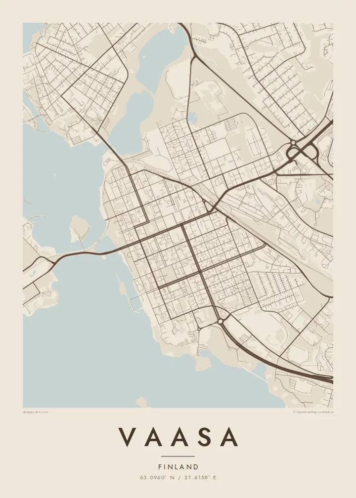
The wide boulevards laid out after the 1852 fire cross the centre in long, open strips, giving the map a strong framework of broad avenues and regular blocks.
Postè kat minimalis · Finland
63.0960° N / 21.6158° E
Wide esplanades on a planned grid by the Gulf of Bothnia, fraying into the islands of the rising Kvarken archipelago.


Yon vil, senk atmosfè
Peze yon style pou wè li sou mi a. Chak style koute menm pri — enprime, ankadre oswa kòm fichye HD.
 Piksèl reyèl · fichye enpresyon 24 × 36″
Byen klè pou enprime
Sa a se yon zoom 100% sou vrè fichye enpresyon an. Chak afich — enprime, ankadre oswa telechaje — jenere sou sèvè nou yo nan 300 DPI, jiska 7,200 × 10,800 piksèl, konsa menm pi piti wout yo rete klè sou yon enpresyon 24 × 36″.
Sou mi a


Kat la
Vaasa, known in Swedish as Vasa, sits on Finland's west coast facing the Kvarken, the narrow part of the Gulf of Bothnia between Finland and Sweden. After the old town burned in 1852, the city was rebuilt several kilometres closer to the sea on a new plan. Broad tree-lined esplanades were laid out as firebreaks, and on a map they divide the centre into a clean, generous grid.
Around this planned core, the coastline breaks into bays, peninsulas and countless islands. The Kvarken archipelago is a UNESCO World Heritage Site, recognised for its rapid land uplift, as the ground continues to rise after the last Ice Age and new land emerges from the sea. The Replot Bridge, the longest in Finland, links the mainland to the island of Replot.
The city briefly served as the seat of Finland's government during the civil war of 1918, a period still remembered in its history. A Vaasa map poster combines two distinct characters: the precise, orderly grid of a nineteenth-century city and the fragmented, slowly changing shoreline beyond it. The contrast gives the print unusual depth.
The wide boulevards laid out after the 1852 fire cross the centre in long, open strips, giving the map a strong framework of broad avenues and regular blocks.
Hundreds of islands and skerries scatter across the sea to the west, part of a UNESCO site where post-glacial uplift slowly adds new land every year.
Finland's longest bridge carries the road from the mainland out to Replot island, drawing a single straight line across open water in the archipelago.
Fè l pou ou
Ajoute yon dat, yon non oswa pwòp fraz pa w, chanje estil, gwosè oswa oryantasyon.
Apèsi gratis la se nan rezolisyon ba avèk yon watèrmak. Enpresyon ak fichye HD yo jenere nan 300 DPI, jiska 7,200 × 10,800 px, san watèrmak.
Poukisa Vaasa
Vaasa draws people through its two language communities, its universities and its energy industry, and many who leave keep a strong attachment to the coast. A map of the city balances street plan and seascape, which makes it a natural fit above a desk or in a hallway.
Set your own title, add a subtitle or a date, and keep or edit the coordinates line. Choose from Classic black & white, Noir, Paper, Blueprint or Sand. The $9 digital download covers six print sizes, and printed posters come on matte paper.
Kòmande afich Vaasa a| Gwosè enpresyon | Rezolisyon | Fichye |
|---|---|---|
| 30 × 40 cm (11.8 × 15.7″) | 3,543 × 4,724 px | PNG · PDF |
| 29.7 × 42 cm (A3, 11.7 × 16.5″) | 3,508 × 4,961 px | PNG · PDF |
| 42 × 59.4 cm (A2, 16.5 × 23.4″) | 4,961 × 7,016 px | PNG · PDF |
| 45.7 × 61 cm (18 × 24″) | 5,400 × 7,200 px | PNG · PDF |
| 50 × 70 cm (19.7 × 27.6″) | 5,906 × 8,268 px | PNG · PDF |
| 61 × 91.4 cm (24 × 36″) | 7,200 × 10,800 px | PNG · PDF |
Pou konpare, apèsi gratis la gen 900 px lajè, li gen filigràn epi li fèt pou ekran. Fichye HD yo gen jiska 8 fwa plis rezolisyon nan chak direksyon epi yo enprime pwòp nan gwosè postè konplè.
Chwazi yon style anlè paj la, epi chwazi Afich Enprime — yon gwosè epi, si w vle, yon kad — oswa Fichye Dijital HD. Peman an fèt nan yon sèl etap, epi paj kòmand ou a mete ajou kou peman an konfime.
Li enprime sou papye mat premium 200 gsm nan youn nan sis gwosè, soti nan 30 × 40 cm rive nan 24 × 36″. Afich enprime yo kòmanse nan {printFrom}, livrezon enkli.
Wi. Chwazi yon kad an bwa solid nan koulè nwa, blan, chenn natirèl oswa bwa fonse. Li vin ak yon vit ki pa kase epi li pare pou pandye. Afich ankadre yo kòmanse nan {framedFrom}, livrezon enkli.
Livrezon an gratis nan tout mond lan. Se pi pwòch nan patnè enprimri nou yo nan plis pase 30 peyi ki enprime chak afich la, epi li anjeneral rive nan 3–7 jou ouvrab. Ou ka swiv estati ak swivi kolis la nan Kòmand mwen yo. Gen kèk peyi ki pran 2–5 semèn, e kote nou poko livre a, sit la di w anvan ou peye.
Voye nou yon foto nan 14 jou apre livrezon an epi nou ap reenprime li gratis oswa remèt ou lajan w.
Wi. Nan editè a sou paj sa a, chanje tit la, soutit la ak liy kowòdone yo pou nenpòt sa w vle, epi chwazi yon style ak yon gwosè. Kòmand enprime, ankadre ak dijital yo tout itilize egzakteman desen w lan.
Pou $9 ou jwenn fichye PNG 300 DPI ak PDF pare-pou-enprime nan tout sis gwosè yo, san watèrmak, pou enprime kote w vle. Pa sèten toujou? Telechaje yon apèsi gratis ak watèrmak anvan.
