Central grid
The core follows a regular pattern of square blocks around the central plaza, a layout that reads crisply in black linework at every print size.
Minimalist map poster · Guatemala
14.7041° N / 91.8643° W
A market town on Guatemala's Pacific slope, its grid spreading across green lowlands toward the Mexican border.



One city, five moods
Ekamowa emwit style ouga bwe ouga ekamowa e dedaña ñan bwega. Style otata a kor eangan — eprint, eframe ke HD files.
 Pixel ekwan · 24 × 36″ print file
Print-sharp
Enin 100% crop eo mai print file eo elango. Poster otata — eprint, eframe ke edownload — erender iaan server bwir e 300 DPI, dedaña ñan 7,200 × 10,800 pixels, bwe lane ekekedik ekwan ebwe crisp iaan print 24 × 36″.
Ituro


The map
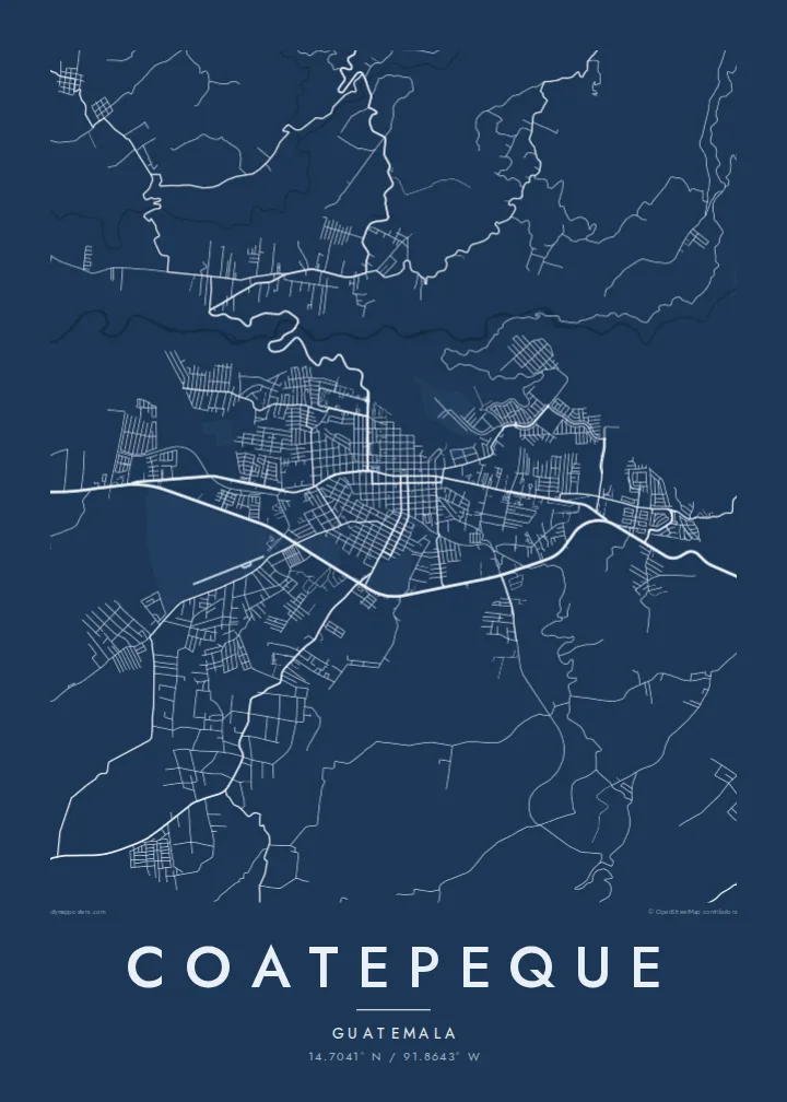
Coatepeque sits in the department of Quetzaltenango, where the highlands fall away toward the Pacific coastal plain. On a map the town appears as a fairly regular grid of blocks around a central square, with newer neighbourhoods stretching out along the highways. Around it the land is agricultural, and plantation roads and small rivers thread through the countryside toward the sea.
The name comes from Nahuatl and is usually translated as hill of snakes. Coatepeque grew as a commercial centre for the coffee and farming country of the boca costa, and its position near the Mexican border makes it an important stop for trade moving between the two countries. The highways leading in and out of town are some of the strongest lines on the map.
A Coatepeque map poster shows a town that feels ordered at its centre and more open at its edges. The central grid gives the composition structure, the roads leave it with purpose, and the rural surroundings keep the image light. It is a clean way to remember a place that many people pass through and many others call home.
The core follows a regular pattern of square blocks around the central plaza, a layout that reads crisply in black linework at every print size.
Main roads leave the centre toward the highlands, the coast and the border, drawing long lines that anchor the town within its region.
Small rivers and plantation roads cut through the surrounding lowlands, adding fine, irregular detail around the more geometric streets of the town.
Make it yours
Add a date, a name or a line of your own, switch style, size or orientation.
Preview ededa low-resolution im watermark. Print im HD files erender iaan 300 DPI, dedaña ñan 7,200 × 10,800 px, ededa watermark.
Why Coatepeque
Families split between Guatemala and the United States often choose Coatepeque as a link to home, and its clear grid makes an understated poster. It works just as well for anyone who has worked in the region or travelled through on the way to Mexico.
Change the title, subtitle and coordinates line to mark a hometown, a wedding or a departure date, then choose Classic black & white, Noir, Paper, Blueprint or Sand. Printed posters are shipped by print partners in 30+ countries, with an optional wooden frame.
Oder poster Coatepeque| Print size | Resolution | Files |
|---|---|---|
| 30 × 40 cm11.8 × 15.7″ | 3,543 × 4,724 px | PNG · PDF |
| 29.7 × 42 cm (A3)11.7 × 16.5″ | 3,508 × 4,961 px | PNG · PDF |
| 42 × 59.4 cm (A2)16.5 × 23.4″ | 4,961 × 7,016 px | PNG · PDF |
| 45.7 × 61 cm18 × 24″ | 5,400 × 7,200 px | PNG · PDF |
| 50 × 70 cm19.7 × 27.6″ | 5,906 × 8,268 px | PNG · PDF |
| 61 × 91.4 cm24 × 36″ | 7,200 × 10,800 px | PNG · PDF |
For comparison, the free preview is 900 px wide, watermarked and meant for screens. The HD files have up to 8× the resolution in each direction and print cleanly at full poster size.
Emwit style iaan capña page, im dogen Printed Poster — size eo, im framme ouga tomwin — ke Digital HD Files. Checkout eaer sit step, im order page bwira eupdate iaan payment eo emej.
Eprint iaan matte paper 200 gsm, iaan size eo eo, mai 30 × 40 cm ñan 24 × 36″. Poster eprint eo emeja iaan $39, shipping ededo.
Eko. Emwit frame wood solid iaan black, white, oak natural ke wood dark. Etaña shatterproof glazing im ready ñan hang. Poster eframe emeja iaan $99, shipping ededo.
Shipping ma free ägen 60+ country. Poster ngaga eo e print ägen print partner nearest ibiema 30+ country, ae e tep ägen 3–7 business day. Ngaga kor status ae tracking ibe My Orders. Country ibiema e tep 2–5 week, ae country ngaga ibe shipping e bwaren, website e ibin oen bwa ngaga pay.
Kabun photo bwira iaan 14 aean mai delivery, im bwira ereprint ededo ke erefund.
Eko. Iaan editor page eanin, ouga change title, subtitle, im coordinates line ñan tomwin ouga koda, im emwit style im size. Order eprint, eframe im digital otata ekamowa design ouga tomwin.
Iaan $9 ouga ereub 300 DPI PNG im PDF print-ready iaan size otata eo, ededa watermark, ñan print ekamowa tomwin. Ouga aewedik? Download preview ededa watermarked kabun.
